For a podcast episode about this place, find The Places Where We Belong and listen to Chapter 1, Part 4.
Is Uluru/Ayers Rock a special place? Sounds like a bizarre question: the rock has become the Yosemite of Australia, not only because it's physically spectacular but, as White Australians younger than John Wayne will tell you, because for thousands of years it's been a place of tremendous spiritual importance. With the reversion of the name from Ayers Rock to Uluru—technically Uluru/Ayers Rock—official Australia has ceded the point, decided to respect the rock's spiritual importance, and allowed that there really is little sense keeping a name intended to honor a politician who never saw the rock and whose business career was devoted to a copper mine.
As Paul Harvey used to say, however—quick, turn the dial!—"the rest of the story" is a little more complicated. By the 1950s, when tourists began arriving, the local Aborigines had been gone for 40 years, and though there was plenty of spiritual meaning in the place, the same thing is true of every other place on the continent. It's outsiders who have elevated the rock to iconic status, outsiders who were nudged and encouraged by a tourist industry that knew a good thing when it saw it. Which isn't to say that the place isn't magnificent.
We're a bit over 1,750 miles northwest of Sydney, via Wagga Wagga, Mildura, and Coober Pedy. We're also stuck, though you have to admit that it's a nice place for that: the fine red sand is beautiful, especially with its ruff of grass. Not a speck of trash. I bite my tongue to avoid saying that this grass—buffel grass (Cenchrus ciliaris)—is native to Africa and Asia and is officially designated a pest in Australia. The eucalyptus belongs.
Daniel Boone would like it here, wouldn't he? Difference is, we have bottles in our cupholders.
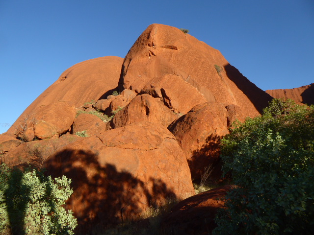
Thar she blows! Ignore the little white blips: they belong to Longitude 131, an extravagant tent-hotel, not for the likes of you and me. Regular blokes wind up in a tourist zone called Yulara, out of sight to the right here—and no bargain, either. The rock is about 1,100 feet high and a bit over two miles long, but those numbers don't do it justice. Professional basketball players, after all, don't look especially tall when they're next to each other.
It behaves like granite, casting off shells.
Boulders accumulate the way they do at the foot of El Capitan.
Before you get too excited about igneous rock, cast an eye on the ridges up top.
Plainly (a word chosen to smooth your skepticism), the rock is sedimentary, technically an arkose sandstone composed of granitic sand. Geologists have worked out much of the history. They report that a Precambrian sea loaded Central Australia's Amadeus Basin with a layer of mud, sand, and gravel about 2 miles thick. During the Cambrian, these lithified beds were warped by the Petermann Ranges Orogeny and formed mountains that began eroding and creating an immense alluvial fan in a new inland sea. A second mountain-building episode about 300 million years ago—the Alice Springs Orogeny—rotated the alluvial fan into a nearly vertical position. The land surface was then much higher than at present, but erosion went to work. Can wind do so much? It didn't have to: until 500,000 years ago, this place wasn't dry.
See I.P. Sweet and I.H. Crick, Uluru and Kata Tjuta: a Geological History, 2001.
Which raises the nasty question of why the rock here endures while the rock once around it didn't. Now the geologists aren't much help. They suggest that the rock has few of the joints that facilitate erosion. Maybe so, but then the question is why the rock has so few joints. Pesky, pesky.
The first white man here was Ernest Giles in 1872. "After a long and anxious scrutiny through the smoke and haze, far, very far away, a little to the west of south, I descried the outline of a range of hills, and right in the smoke of one fire an exceedly high and abruptly ending mountain loomed." Giles returned the following year but found another white man on the spot, the explorer William Gosse. It was Gosse who named the rock after Henry Ayers, then the premier of South Australia but previously the managing and penny-pinching director of the copper mine at Burra.
Note: the rock is not in South Australia; it's in the Northern Territory, but South Australia had annexed the Territory in 1863 and did not cede it to the Commonwealth until 1910.
See I.P Sweet, A.J. Stewart, and I. H. Crick, Uluru and Kata Tjuta: a Geological Guide, 2012, p.2.
The name Uluru appeared in print for the first time in 1914 on a map drawn by Herbert Basedow for the journal of the Royal Geographical Society of Australasia. Basedow was a German-educated medical doctor and anthropologist who devoted himself to the study of Aborigines and believed that Australia was guilty of "racial homicide." He died in 1933, a decade before the word "genocide" came into the English language.
Up close, the cetological analogy loses its force. This is probably a good place to point out that the white stuff in the caves is the deadly poison known to the Aborigines as arangulta or arukwita. Really? Well, sort of really.
Time to meet William Edward "Bill" Harney, who in 1958 was appointed "keeper" of the rock—the first ranger. He later wrote that before he arrived an old Aborigine he knew said, "When you get to my country you will know nothing. What about I come out there to tell you the story?" (See Harney, To Ayers Rock..., p. 31.)
And so began Harney's education. He writes elsewhere: "Two old men of the Uluritdjas were brought to join me on my first sojourn at the 'rock'. They had been born and initiated there over fifty years before. As we wandered along the base of the mountain, they decided to tell me its story. I would say nothing, for asking too many questions would upset their thinking. After a time, we would pause at a certain place in front or below a rock, the sight of which symbol refreshed their memories and soon they would begin chanting in a low voice which slowly increased in volume as they remembered it." (See Harney, The Significance of Ayers Rock..., p. 1.)
Harney retired in 1961 and died later that year. He had already published "The Dome of Uluru" in Walkabout (1957), and two other works appeared posthumously: To Ayers Rock and Beyond (1963) and The Significance of Ayers Rock for Aborigines (1968).
All seems settled until you bump into T.G.H. Strehlow (1908-1978), a linguistics professor. Strehlow's parents were Lutheran missionaries in the Outback, and their son grew up with an Aboriginal language as his mother tongue. Later, in the 1960s, he would write that public interest in Aboriginal mythology was "likely to lead to the wholesale production of worthless mythological accounts written by the uninformed for the ignorant. For one of the most frustrating characteristics of Aboriginal religion is the veil of deep secrecy behind which the most important parts of the sacred beliefs and ritual have always been hidden to guard them from uninitiated persons and from strangers. The few trusted white 'outsiders' who have been granted glimpses of this sacred world have invariably been put under a solemn obligation to divulge only a minimal amount of their religious information."
Strehlow continues: "Ultra-inquisitive intruders are commonly fobbed off with untrue stories.. as can be readily seen in the large amount of fictitious rubbish that is already being retailed by tourist guides (and others) to an unsuspecting and gullible public."
Referring specifically to Harney, Strehlow wrote: "Bill Harney did not know any of the Centralian languages. He had come to Central Australia only halfway through World War II and his best Aboriginal contacts were with the Top End folk." So were Harney's guides telling him the truth or "rubbish"? To complicate things, Strehlow himself has his critics. So! Is the white stuff poison?
See Strehlow's "Mythology of the Centralian Aborigine," in The Inland Review, June/August, 1969.
So here, in that shadow on the right, we have a nice demonstration of sandstone behaving like igneous rock and, on the same spot, a rock that Harney says "symbolises the Dreamtime ana (digging stick) of the Inma ritual." Just to make things more interesting, the shell has also been called a knife that a poisonous snake used to kill a young carpet snake. That interpretation is found in Charles P. Mountford's Ayers Rock: Its People, Their Belief and Their Art (p. 43).
Strehlow would not have us make too much of such stories, even when they correctly convey Aboriginal belief. He writes that "...it is wrong to imagine that only The Centre's more striking natural features had ever been places of sacred eminence for the surrounding tribal territory. It is much nearer the mark to state that, until the coming of the white population the whole of Central Australia, in a very real sense, was a sacred land for its original inhabitants." (See the Inland Review, June/August, 1969, p. 12.)
Elsewhere in the same essay Strehlow writes: "In Central Australia, every landscape feature was associated with some mythological episode or some sacred verse. Hence mythology was validated by the geography of the whole countryside... not merely by a few major waters or prominent mountains. Some of the greatest episodes commemorated by the Central Australian traditions are, in fact, associated with sites in which no modern sight-seeing tourist would be interested....
"It cannot be stressed too much or repeated too often that the religious importance of a major totemic site in Central Australia was not determined by any spectacular aspects of the landscape, but purely by the sacred myths, songs and acts that had been attached to it by age-old tradition. Considered as a major totemic centre, Wapirka, though situated in what might be termed a mean and commonplace landscape that few tourists would bother to notice, outranked by far Ayers Rock, despite the spectacular scenic magnificence of the latter which rightly evokes the admiration of all white visitors, regardless of its old tribal significance." (Ibid., p. 11-13.)
One of many lenticular caves, this one was perhaps (or perhaps not) the camp of sleepy, blue-tongued lizard. The whitish smudge above and to the right of the cave is (or is not) the smoke from his camp.
What lizard are we talking about? We read that Aborigines believe that the world was timeless and formless until totemic ancestors—some in the shape of animals, some in the shape of plants, some in the shape of humans—rose from under the earth at sites later regarded as sacred. From these ancestors descended the plants, animals, and humans of today. These ancestors were mutable in the sense that animals could become humans, and so it was that different groups of aborigines regarded particular species of animal or plant as their totemic ancestor.
Harney's description of this cave is hard to find in print and so, despite its precarious veracity, I quote it in full: "...here on this place some Loongardi [sleeping lizard] men were cooking a Kuliar (emu) when two hungry hunters, who were hunting this same emu, came out of the south-west and craved hospitality. But the Loongardi had heard of their coming and cutting up the emu flesh, they hid it away and refused the strangers' request. Becoming angry over this lack of hospitality, the strangers picked up a fire-stick and destroyed many of the Loongardi and their kindred people, the kunia. The grey lichen stained cliff in the area is called meta camba (place of the burnt sleeping lizards), and the boulders at its base are the bodies of the roasted people." (The Significance..., p. 9.)
The caves aren't all lenticular. Harney says this cave on the north side is now called 'The Brain' but was "the traditional home of the Loonba (red-backed kingfisher) who is recorded in legend as the one who first gave the Mala [hare wallaby] men a warning that an evil being was coming to destroy them.... This evil is the mythical Ritual Dog Kurupunyi which had been sent by the Windralga (mulga-seed) people of Kikingurra many miles to the west...."
There are simpler versions which call this cave simply the camp of the old Mala or hare-wallaby men. For example, see Mountford, p. 84.
For those who think Australia's critters are mostly 'roos and emus, the hare-wallaby is about 16 inches long and weighs about five pounds. There are many species, however, and the central hare-wallaby is extinct.
William Gosse presumably knew nothing of these myths yet was still struck by the caves. He wrote: "The hill as I approached, presented a most peculiar appearance, the upper portion being covered with holes or caves. When I got clear of the sandhills, and was only two miles distant, and the hill for the first time, coming fairly into view, what was my astonishment to find it was one immense rock rising abruptly from the plain; the holes I had noticed were caused by the water in some places forming immense caves." (Quoted in ...Geological Guide, p. 2.)
Wonder about the dimensions?
Here's one of these channels. It's at the base of the rock and has a diameter of about four feet.
Water has etched these ridges, here overlooking the Kundju Gorge, still on the north side. Alternatively, the gutters were dug by Kundju, the ancestral lizard, in search of a lost boomerang.
Here's one of the two permanent waterholes at the rock.
It's the Kandju waterhole and/or the dry-weather camp of the ancestral lizard Kandju himself.
We've come around to the south side of the rock, the site of an epic battle between the carpet snakes (kunia) and the poisonous snakes (liru).
The rock here looks as though it had melted and then congealed.
Come up and pat the stone. You'll be surprised if you expect a coarse sandstone easily scraped by a key. This stuff is hard.
A stream comes down the rock to another perennial pool, this one called Maggie Springs or Mutidjula. Harney writes: "Mutidjula (Maggie Springs) is an important rock hole and is noted for its sacred lethal chants and its magic poison Arangulta which is said to destroy those who are foolish enough to sink deep wells around it.
"Above it, in a ravine that comes in from the eastward is the sacred Ngati (rock-hole) of Uluru reached by a very hazardous pathway that runs up the eastern cliff wall to the right of Mutidjula. This is Kapi Agalyu Wanambijarra (Sacred Water-python place). The sacred, but not secret, serpent of Uluru has its abode in this water of Uluru and should its Uluritidja people come to the Rock and find Mutidjula empty, they will stand in the dry pool and cry aloud Kuka...Kuka...Kuka (meat... meat...meat). This lures the serpent from its resting place, and as it moves, it disgorges water from within it, which flows down to the thirsty people below." (Harney, The Significance..., p. 11).
Here's the pool. Harney writes: "To the Uluritdja, the mountain symbolises their tribe and held the essence of life in the rock pool of Uluru (Maggie Springs), sacred to the 'all knowing and everlasting' serpent, Wanambi."
Nearby, a slab of rock is understood to be the nose of a Liru or poisonous snake. It was cut off by a kunia or carpet snake ancestor.
Had enough myths that might or might not be? Here's something more certain: a poster on the AYQ airport wall. Flights come from Alice Springs, Brisbane, Cairns, Melbourne, and Sydney and are operated by Qantas, Virgin, and Jetstar. The ancestral totem is Connellan Airways, which was based in Alice Springs and operated from 1939 to 1980. Eddie Connellan landed the first plane at the rock in 1938, and regular passenger service began 20 years later at a strip about half a mile northeast of the rock. The strip was closed about 1980 but is still visible on satellite imagery.
Almost a decade before the first commercial flight, Len Tuit began operating Central Australian Tours with buses from Alice. In his first year, 1952, he brought a total of 12 tourists. The Administrator of the Northern Territories had declared that there was "no future in tourism in the Northern Territory, least of all Ayers Rock," but Tuit dug a well on the east side of the rock and eventually erected a long corrugated-iron hut for a lounge, a kitchen and a dining room. Later, two washrooms were built. Guests and employees—the ranger Bill Harney, too—stayed in tents.
Edna Bradley, who spent a year as a waitress here in 1958, wrote that she was told that "Eddie Connellan is going to start flying tours out here. He could only fly over before, but now he's got permission to land and pretty soon he'll have his own Chalet...."
The pilot of the first plane proposed a toast: "To the future of aerial tourism. Then he looked around the room, "Ya know, this could be a goer." He sat down, nodded his head and said, "You know, we're really going for the international tourists for this.' 'Ya won't get that many,' said Malcolm [another Tuit employee], not a lot of tourists are interested in Central Australia.'" (Edna Bradley, A Rock to Remember, pp. 91-93.)
In 1960 Ansett-Pioneer took over the Tuit camp and renamed it the Red Sands Motel. The Boomerang Hotel started 18 months later, followed by the Inland Motel and the Uluru Motel. Red Sands was still in business in 1976, when 50,000 visitors arrived, but Australia's governor general in that year proclaimed the creation of a new village, Yulara, eight miles from the rock.
It took a few years before the first hotels opened, complete with shopping center and laid out in a curvilinear plan developed by Philip Cox and Associates. All the old hotels lost their leases, and their land reverted, along with the air strip, to what is now called Parks Australia. Ownership of the park land was transferred to the local indigenous peoples, who leased it back to the parks agency for 99 years. Ownership of the hotels has changed several times but settled in 2011 in the hands of the Indigenous Land Corporation. By 2015 the new airport, which opened in 1982, was handling over 300,000 passengers annually. Hotel reservations in the cool of winter are scarcer than marsupial eggs.
See http://www.coxarchitecture.com.au/project/ayers-rock-yulara-resort/
And so! Here's the Kuniya Carpark, where people can walk to the Mutiljala waterhole.
Don't have a car? No problem. Yes, that's the airport; there are about five arrivals daily—737s and similar models.
Each evening a dozen buses stop to let visitors watch sunset at the rock.
Climbing the rock has never been easy or safe. Edna Bradley recalls a discussion from the 1950s. "'What they should have here, is something to hang onto, like a chain.' But others said that would be terrible, just imagine how ugly it would look..." (Bradley, p. 154).
The chain was installed in 1964, and despite signs imploring visitors not to climb, many visitors do—or did, until climbing was prohibited as of late 2019.
You won't find any Aboriginal community nearby; one exists, complete with post office and store, but it's off-limits, which is probably wise, considering what would happen if tour buses were allowed in.
Too many people? Great: head 30 miles west to Kata Tjuta, alias Mount Olga. The road continues more or less forever, to Warburton, Leonora, and Kalgoorlie, 940 miles ahead. Beyond Kata Tjuta, however, the road is the mostly unpaved Great Central Road, permit required. The camels are feral.
Ernest Giles, the same Giles who "discovered" Ayers Rock, saw these mountains ("Many Heads" in the Pitjantjatjara language) and named them after Grand Duchess Olga, daughter of Czar Alexander III and brother of Czar Nicholas II. The name of the mountains was officially changed in 1993 to Mount Olga/Kata Tjuta and then in 2002 to Kata Tjuta/Mount Olga. The link between Ernest Giles and Olga is through Ferdinand Mueller, the Government Botanist in Victoria. He supported Giles and had been named a baron by Charles of Bavaria, who (bingo!) had married Olga. It's not quite as crazy as it sounds: Olga was a serious collector of minerals, a useful hobby and therapy for a woman who had no children because her husband had no interest in women.
Giles wrote that the appearance of these mountains "was most wonderful and grotesque. It seemed like five or six enormous pink hay-stacks, leaning for support against one another, with open cracks or fissures between, which came only about half-way down its face. I am sure this is one of the most extraordinary geographical features on the face of the earth, for, as I have said, it is composed of several enormous rounded stone shapes, like the backs of several monstrous kneeling pink elephants." See Ernest Giles, Australia Twice Traversed, 1889, vol. 2, p. 11.
We can work our way up between the "heads."
To a point.
Find a piece that's broken loose, however, and it's obviously different unlike Uluru. Say hello to the Mt. Currie Conglomerate. Giles described it "untold masses of round stones of all kinds, mixed as plums in a pudding."
The rock forms cliffs as steep as Uluru.