Sell out! How could this website offer tourist advice? But here we go. We'll make a circuit of the island's tourist nodes, all on the coasts, of course. We'll start at three o'clock, go over to seven, up to eight, then up to 12. That touches the main bases, so long as you don't insist on the Westin, Oberoi, Meridien, and Radisson. Handy, having a nicely ovoid island.
So here at three o'clock is a promenade replete with palms at the site of the demolished railway station at Mahébourg. The town is named for none other than Mahé de La Bourdonnais, the unlucky father of the French settlement of Mauritius.
When the French lost the island to the British they lost it here, at the Battle of Île de la Passe, in 1810. An obelisk remembers the event. In the distance: the aptly named Lion Mountain, though Sphinx might have been even better.
Governor Jerningham must have been in transit, because he was already in the middle of his subsequent appointment as governor of Trinidad. His replacement, Charles Bruce, was India-born, a Yale graduate, and a former professor of Sanskrit at Kings College, London. Must have got tired of faculty meetings.
Watch that mortar! In 1950 the government, still British, bought this fine 18th century French mansion in Mahébourg and converted it into a naval museum.
You could stable elephants on the upper floors.
That's Mahébourg over at the east end of the railroad from Port Louis. The map shows how the French and British governments parcelled most of the island into a zillion concessions. Rectangular, yes; gridded, no. Very French, as anyone who knows riverine Quebec or Louisiana can confirm.
So Mahébourg became a center of cane production, which was why this fine bridge was built across the Rivière la Chaux. The earlier timber bridge couldn't sustain the loads.
Hard to read? "This bridge was constructed by the P.W. Dept. from the designs and under the supervision of the Director of Public Works, Mr. P. Le Juge de Segrais, M.I.C.E., during the governorship of Sir Cavendish Boyle, K.C.M.G."
Boyle had previously been Governor of Newfoundland, where he wrote "Ode to Newfoundland," which became that island's official and still sung (or mouthed) anthem. Le Juge de Segrais, on the other hand, was a Mauricien who studied at the famous Cooper's Hill engineering school, not far from what is now Heathrow airport. Unlike the governors he worked for, working in Mauritius was, for him, working at home.
Location of the old timber bridge? Maybe.
But that's not why we're here. We're looking for places to loll. See how calm the water is? You can just make out the protective coral reef on the horizon.
If you want to stay ten minutes from an airline check-in counter, this is the ticket. We're less than three miles south of Mahébourg, and we're also directly under the flight path of aircraft using the island's one runway, which is about half a mile inland. It's dramatic, with Emirates A380s coming and going. For the moment, things are quiet here at Blue Bay, which is where one of the island's first hotels catering to tourists opened in 1964. Then it was called the Beachcomber; now, expanded, it's the Shandrani. It's over there, at the far end of the beach.
There are other choices, too.
We've jumped about 15 miles west to the Black River Gorge. This is about 20 miles south of Port Louis, and it's inland a couple of miles from the southwest corner of the island. It's also about as rugged as the island gets, although a road makes access easy. Assume you'll have lots of company.
From near the same place, here's the view west toward the village of La Galette.
And here's the view to the south coast, six miles away.
Parts of that south coast are unprotected by reefs. Here's a lonely road heading toward such a part. Yes, that's an abandoned sugar-factory chimney. The modern plant is behind us a couple of miles.
Somebody has a taste for history. We're still on the same road.
Approaching the coast, the road is lined with something you don't see here much: stone walls built, perhaps, to enclose pastures.
End of the road. See what happens when there's no protective reef?
Just 3,000 miles of open water stretching to Antarctica.
K'pow! You'd think someone might try opening a hotel for people who want to watch, but the theory seems to be that visitors demand a sandy beach.
Duh.
Farther west, a reef once again protects the coast. We're standing on a public beach; beyond the guard, the beach belongs to the first of a dozen hotels at this corner of the island.
The eye-catcher here is Le Morne Brabant, a volcanic plug rising almost 2,000 feet from the sea.
A road winds around the south side of it.
The mountain was famous in the 18th and early 19th century as a refuge for escaped slaves who apparently lived up top or in small caves. The mountain itself is today fenced and inaccessible.
If it wasn't for that monument over on the right, you'd drive past here without stopping.
Any ideas?
The séga was and is a Mauritian musical genre possibly derived from Madagascar. Sung in creole originally by slaves, it is traditionally accompanied by ravanne (a relative of the tambourine) and triangle. Who sang it here and when? Good questions.
Another relic, easy to miss.
Even escaped slaves had to buy a few basics. Presumably they carried them back up the mountain to their hideouts.
Because of its connection with slavery, Le Morne has been on the UNESCO World Heritage list since 2008. There isn't much to see, however, apart from those relics we just looked at. A sculpture garden has been added at the western foot of the mountain.
Emerging into freedom? The smaller figures at the top allude to the traditional belief that in 1835 the escaped slaves on the mountain killed themselves when they misunderstood the intentions of an approaching British military detachment sent to inform them that slavery had been abolished.
Passive resistance.
We're on the west side of the mountain, where a good road leads to the hotels lined up here. Some juxtaposition, no?
Nice palm tree, huh?
The Lux le Morne?
The St. Regis? I get so confused.
We're looking north from the toe of Le Morne. We're heading up to the beach beyond the first peaks. Call it nine o'clock.
Along the way we pass the Tamarin salt fields. Without a sign, they'd be enigmatic, especially when they're not in use.
The brine gets more and more concentrated as it passes from level to level.
Think sea-bathing has much appeal to people making salt?
But sand and sea are everything for vacationers. That's Le Morne in the distance. The white-topped wall down the beach marks the boundary of a hotel property.
Voilà! Next door there's a Sofitel.
There are lots of apartments in the neighborhood, too. The village is Flic en Flac, a fantastic name allegedly corrupted from a Dutch phrase but fun enough to stand on its own.
And a shopping center. Yippee!
No wheels? No problem.
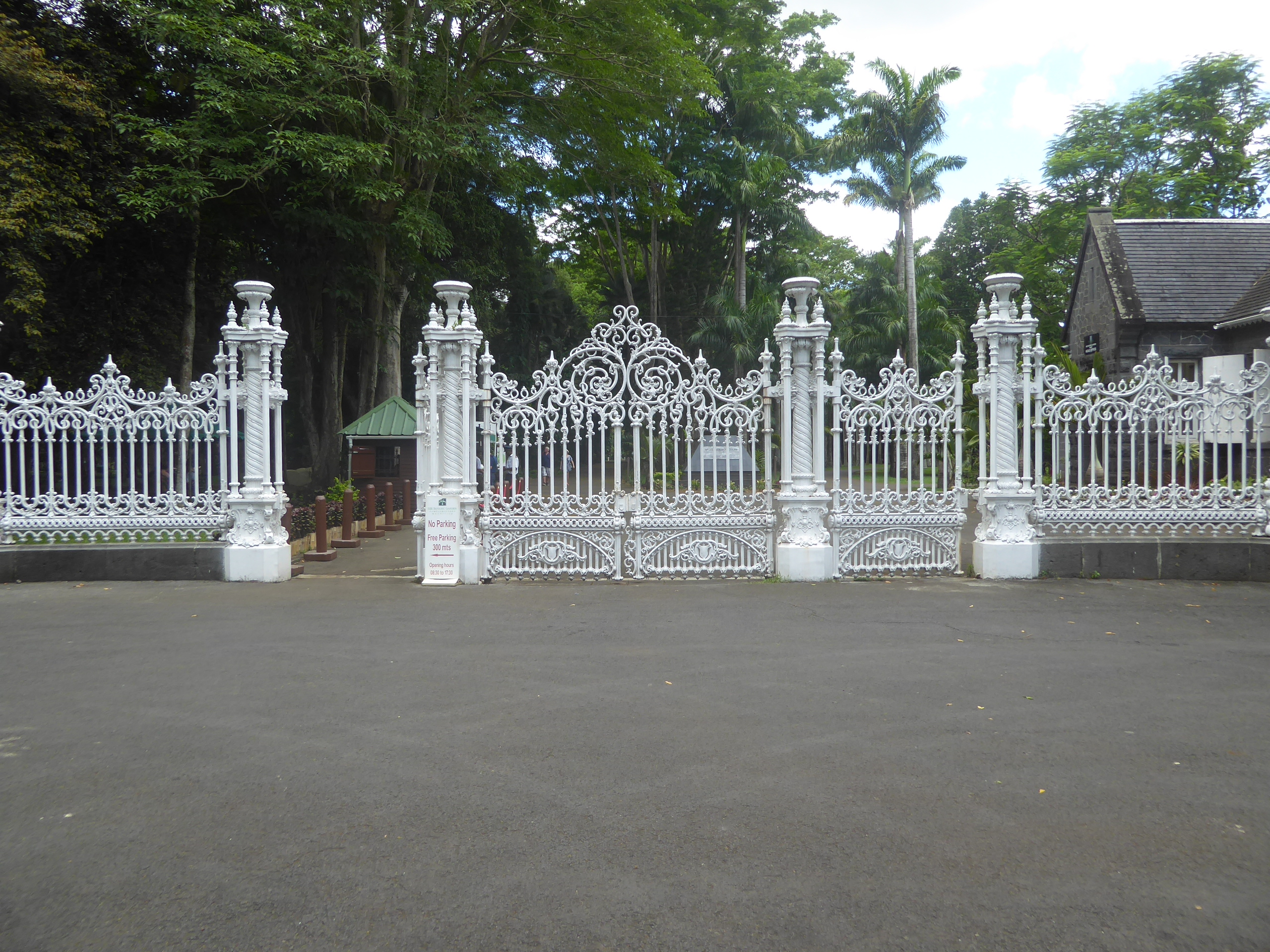
We're on our way north but have detoured a bit to check the Royal Botanical Garden, covering 60 acres at Pamplemousse. The tremendous gates won a prize at London's Crystal Palace in 1862, but the gardens were established much earlier, in 1729, on an estate called Mon Plaisir. La Bourdonnais bought the place in 1735, and it later became the property of Pierre Poivre, who introduced spices and ornamentals. In 1810 the government took over but neglected the place until James Duncan was appointed director in 1849. There's been no backsliding since.
A palm avenue.
Among the introductions were these giant water lilies,* Victoria amazonica*.
They're cared for.
A hundred meters from the front gate there's a large and mostly French cemetery.
Across the street from it there's the oldest church on the island, the Church of St. Francis of Assisi, from 1756.
And out in front of the church there's a bust of unlucky La Bourdonnais.
No time to cry over his bad luck: there's shopping ahead at La Croisette, the mall near Grand Baie, at the north end of the island.
Here's Grand Baie itself.
Shall we be nice and say that the waterfront is developed?
Back a block, everything's residential.
There's not much old stuff here. One exception is this building from the 1860s, now one of the island's half-dozen public libraries but originally, presumably, a district magistrate's office.
Rurul slum? Maybe that's unkind, but east of Grand Baie the plain is pocked with various kinds of hotels and rental accommodation. Gunner's Quoin, its peak almost 3 miles offshore, is uninhabited.
Persist and you can find quiet beaches up here, too. The block on the left houses a tiny Hindu shrine.
We complete the circuit by returning to Mahébourg.