Thirty miles upstream from Ollantaytambo—a bit more as the water flows—there's another royal estate. Like Ollantaytambo, Pisac was built by Pachacutec on the site (one might add "and on the backs") of a conquered people, in this case the Cuyos.
Looking north, down the Urubamba Valley 30 miles upstream from Ollantaytambo. The town of Pisac is a mile behind us, farther up the valley.
How much money is there in a field of corn, here spread out to dry?
More than you might think, when the corn has giant kernals ready to be fried and exported as a snack.
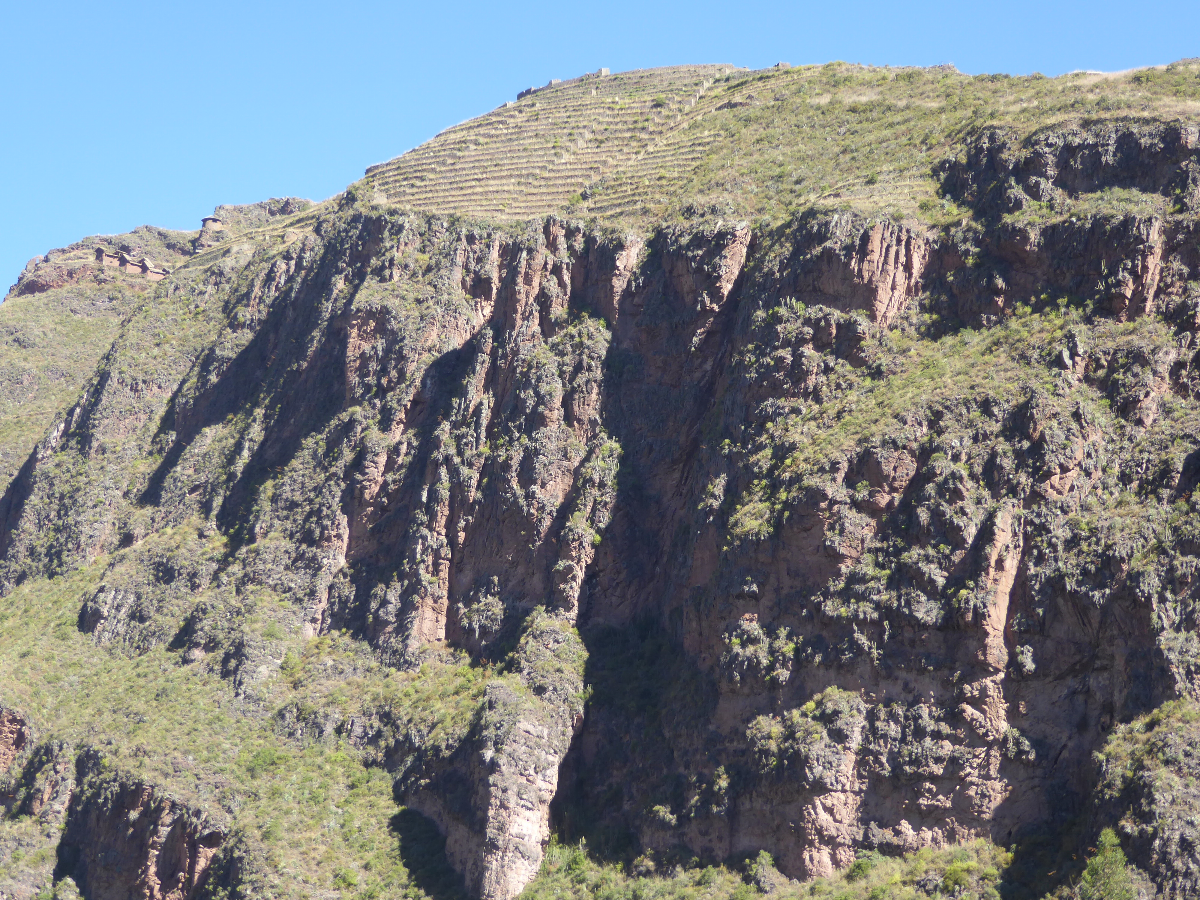
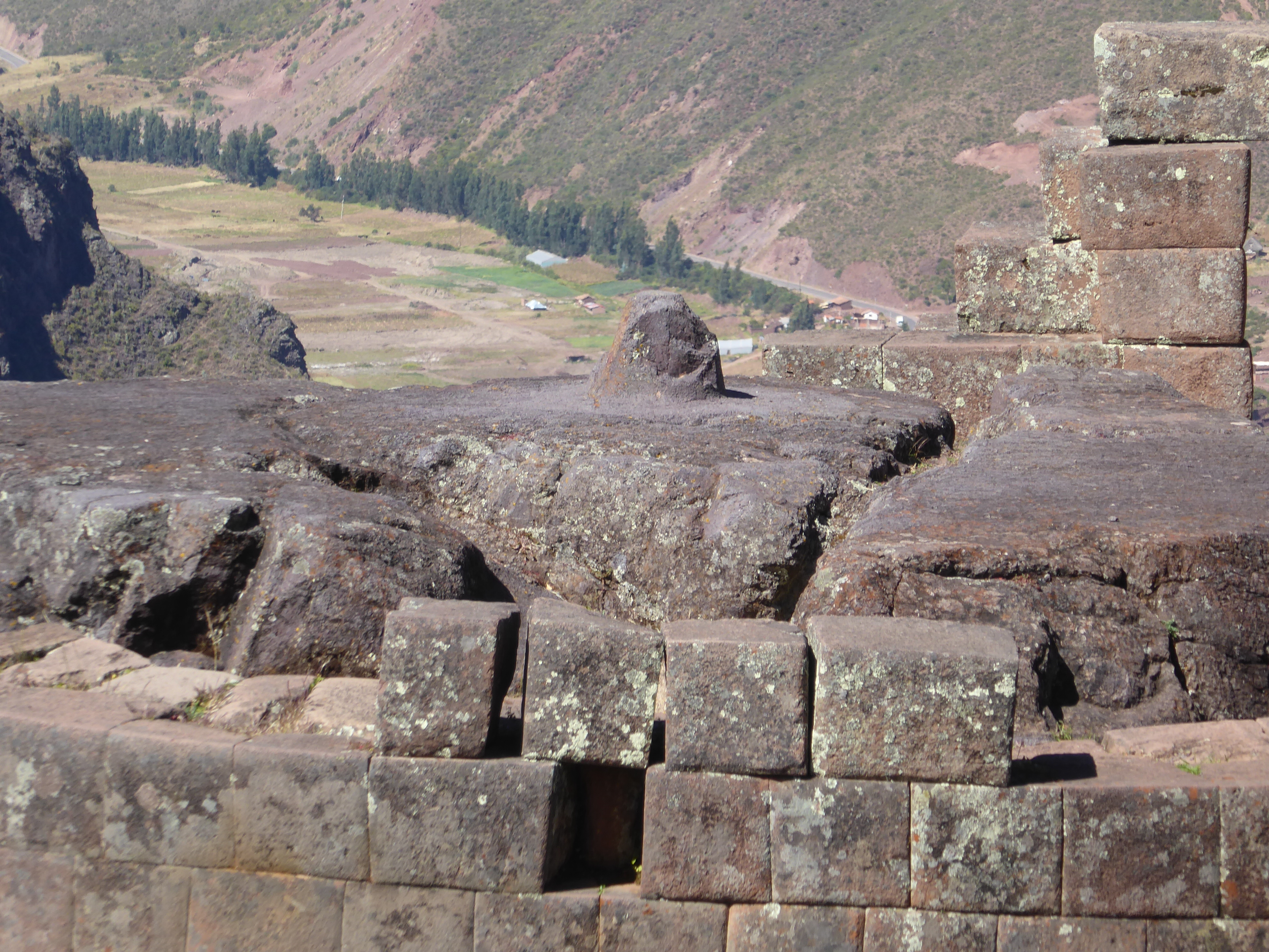
The picture a moment ago of the Urubamba Valley came from that road you see curving up the opposite slope and heading to Cusco. The town on the valley floor is Pisac ("partridge" in Quechua). We've obviously climbed up the opposite side of the valley and are standing (carefully) on the edge of a canyon bounding a narrow ridge. The Quitamayo River flows down there.
We've moved to the bottom of the Chongo valley, on the other side of the ridge. The houses up top are P'isaca, once the vacation home of Pachacutec and other Inca nobles. (You're right; the Inca didn't take vacations. What shall we call it? His "retreat"? But Pachacutec never retreated. Hang-out? You see the problem.) Anyway, the startling thing is probably the terraces extending to the cliff edge. The analogy is an American homeowner who plants a perfect lawn right to the cliff edge of his backyard.
Not to criticize, but even Pachacutec didn't finish the job. Can you imagine that? So many hills; so little time.
We've come up the canyon a bit higher and have to concede that what he did, he did surpassingly well. Later we'll be traipsing along that path you see up top.
See that blank cliff face on the right?
Here it is again, now on the left, so we're looking at another set of terraces. Have to use your imagination to see them planted to corn or potatoes and to see irrigation water spilling down step after step. Quite a sight, though again I'm annoyed that the Inca didn't finish the job. Look at all that rough scrub!
Peter Frost writes that as late as 1999 some of the terraces were still cultivated.
Here we are at the top of the terrace set and looking up the Chongo Valley and back across the terraces to Qantu Rachay, maybe barracks or a stronghold. Around the corner, several dozen tourist buses cool their jets. It's sobering to scan the distant slopes and find plenty of rough terraces built by farmers working so hard to scrape out a living. Maybe driving a tourist bus or washing dishes in a Pisac restaurant isn't so bad.
The Peruvian equivalent of the parking lot for the Sphinx.
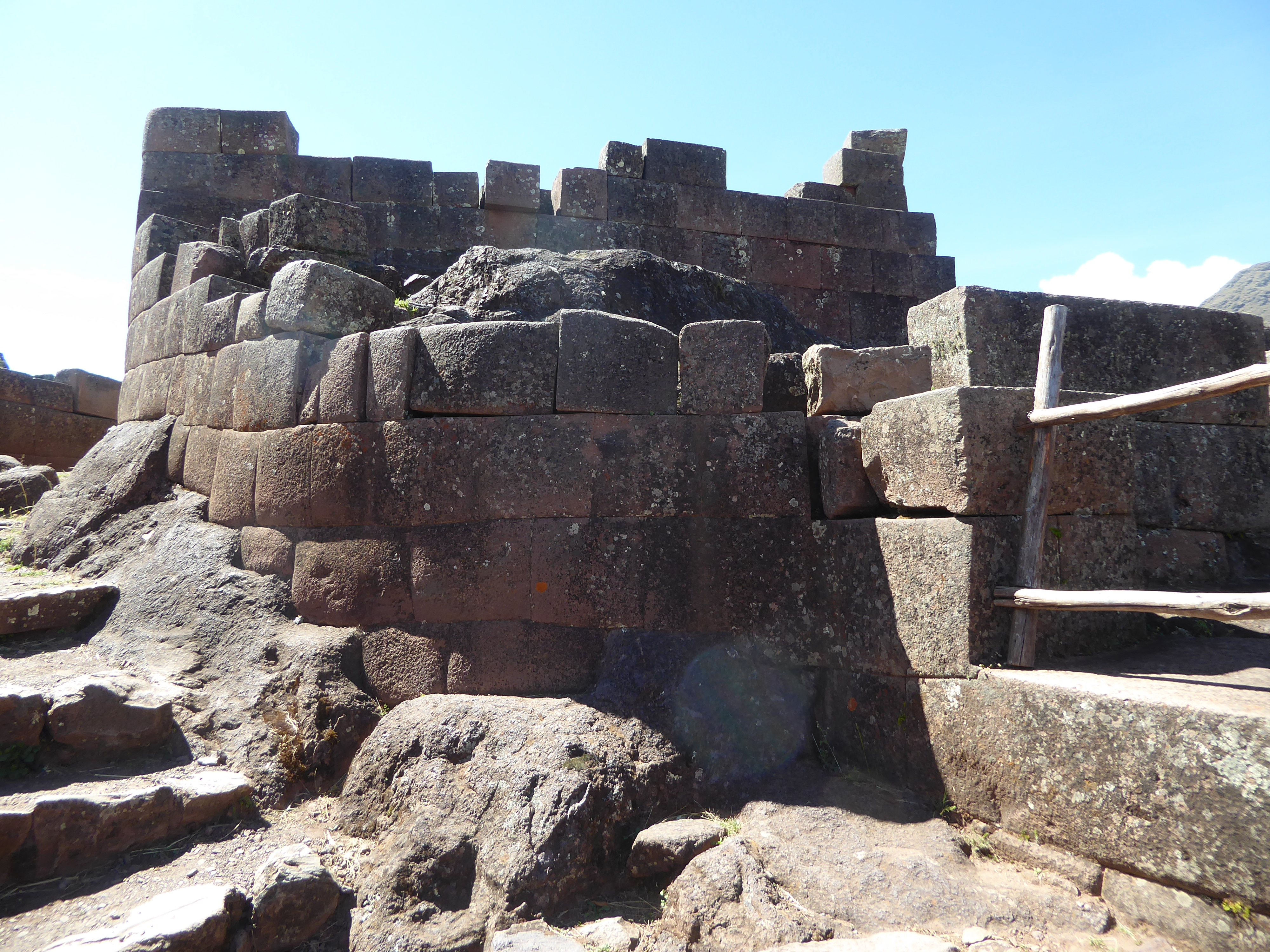
A terrace or andene wall. Is it just as Pachacutec left it? Good question, because photographs from 1900 (for example, Bingham's from 1913) show many of today's immaculate terraces unkempt and even broken down. Probability? This has been patched up or even rebuilt.
Here's the real thing, seen from the top of the terraces and looking out along the ridge crest toward the west. There's a path atop the wall, though it's hiding here.
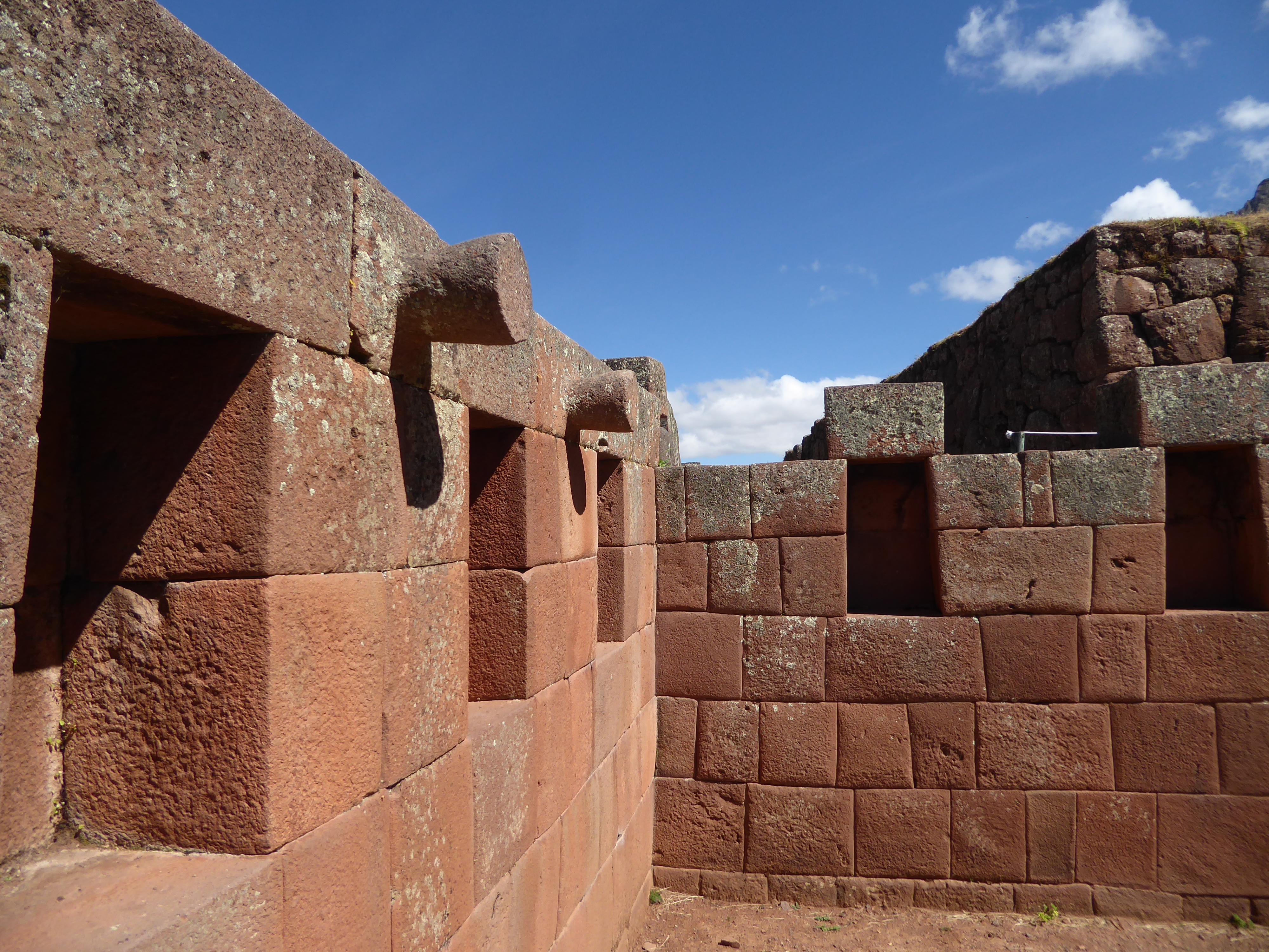
Here's a doorway—the so-called Amaru Punku, or Serpent Door—on the path. The door itself is long gone but was apparently raised and lowered, rather than swung.
Writers for centuries have commented that you can't insert a knife between the tight-fitting joints, and I totally missed my chance to test the proposition. Anyway, I'm more impressed by the curved wall.
We could tootle along the path and then work our way up to the crest.
Alternatively, we could back up. See the Serpent Gate? Up above are the quarters called Kalla Q'asa. "Quarters" is another fine term masking ignorance about who lived in them.
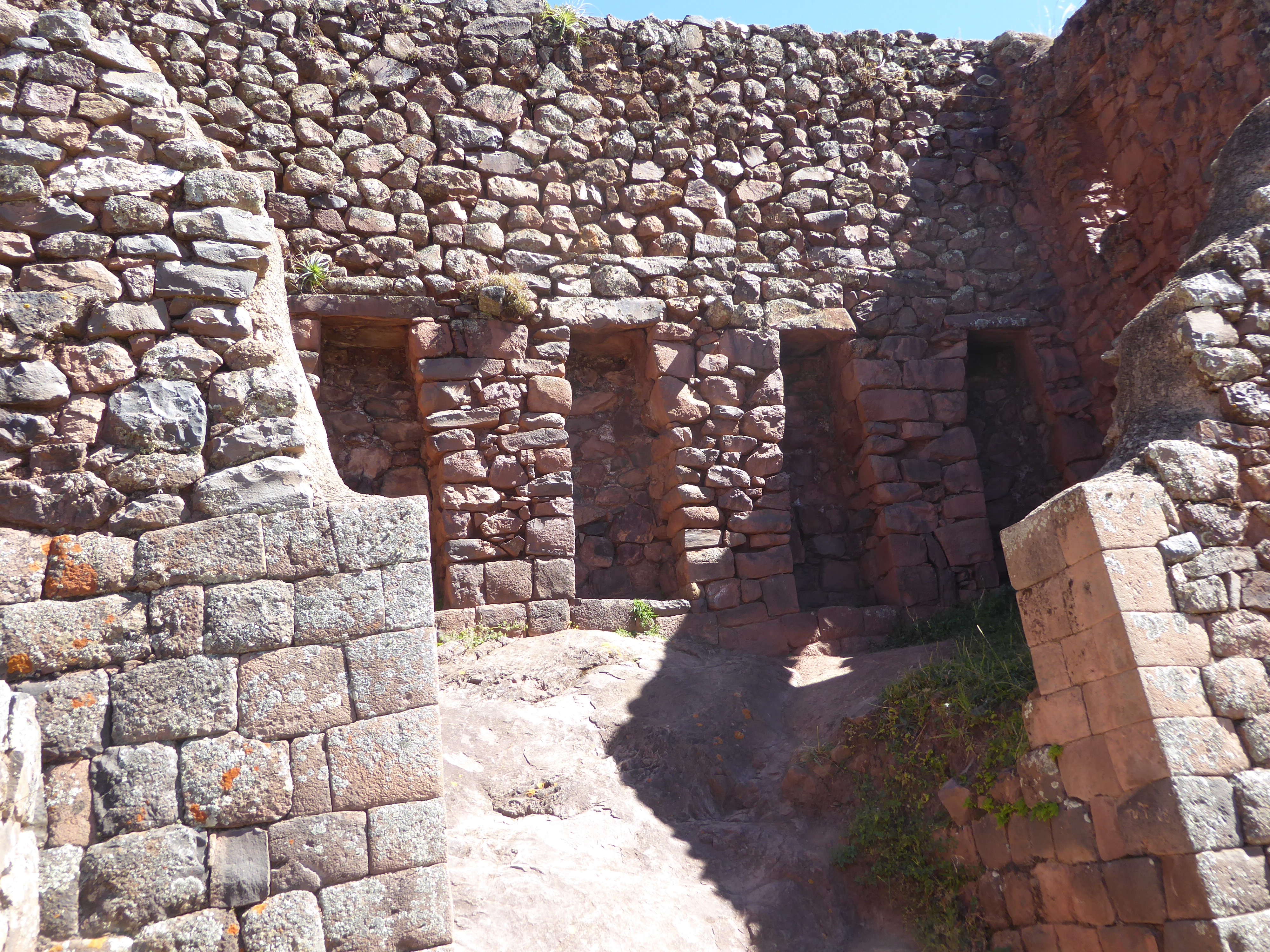
The walls are plenty solid, but not of the best Inca quality, so the implication is that though the location is grand the occupants weren't.
Mundane structures. The thatching is a reminder that Inca buildings even of the most perfect stonework were thatched. Odd combination: materials that last forever combined with a material that must be replaced every few years. In earthquake country maybe it's a good idea.
Why the recesses? More to the point: why the juxtaposition of crude and semi-fine work? Answer: you need a better guide.
Here's a clear exception to the assertion that the buildings here were mundane: in the midst of rough work there's a fine wall. Shall we hazard a wild guess? The service personnel who lived here needed their own temple. After all, that's the building on which villagers and townsfolk everywhere have traditionally lavished their attention.
View back toward the north, with a ceremonial platform and a bit of terracing on the north face of the ridge.
See where you are?
We've moved south along the ridge and have stopped to look west across the Quitamayo and up the slope across it. The path here is very civilized and a great improvement on the one followed by Ephraim Squier in the mid-19th century. He writes: "Along such narrow pathways, where the condor sails level with you above the abyss below, and where you lean inwards till your shoulder grazes the rock, along such paths as these, which from the valley do not form even a line on the face of the precipice, the visitor to Pisac must make his perilous way" (p. 529).
I know, you want to see the floor of the chasm, but you can't, not without wings.
Just a peek.
Here's what seems to be the end of the ridge, but what we're really after is still farther along, at a lower elevation.
What happened? We've regrouped back in the elegant ambience of Urubamba. We're on our way back to Pisac but have stopped dead here. See why?
Yes: it's the Inca wall-building tradition, on display in unexpected places.
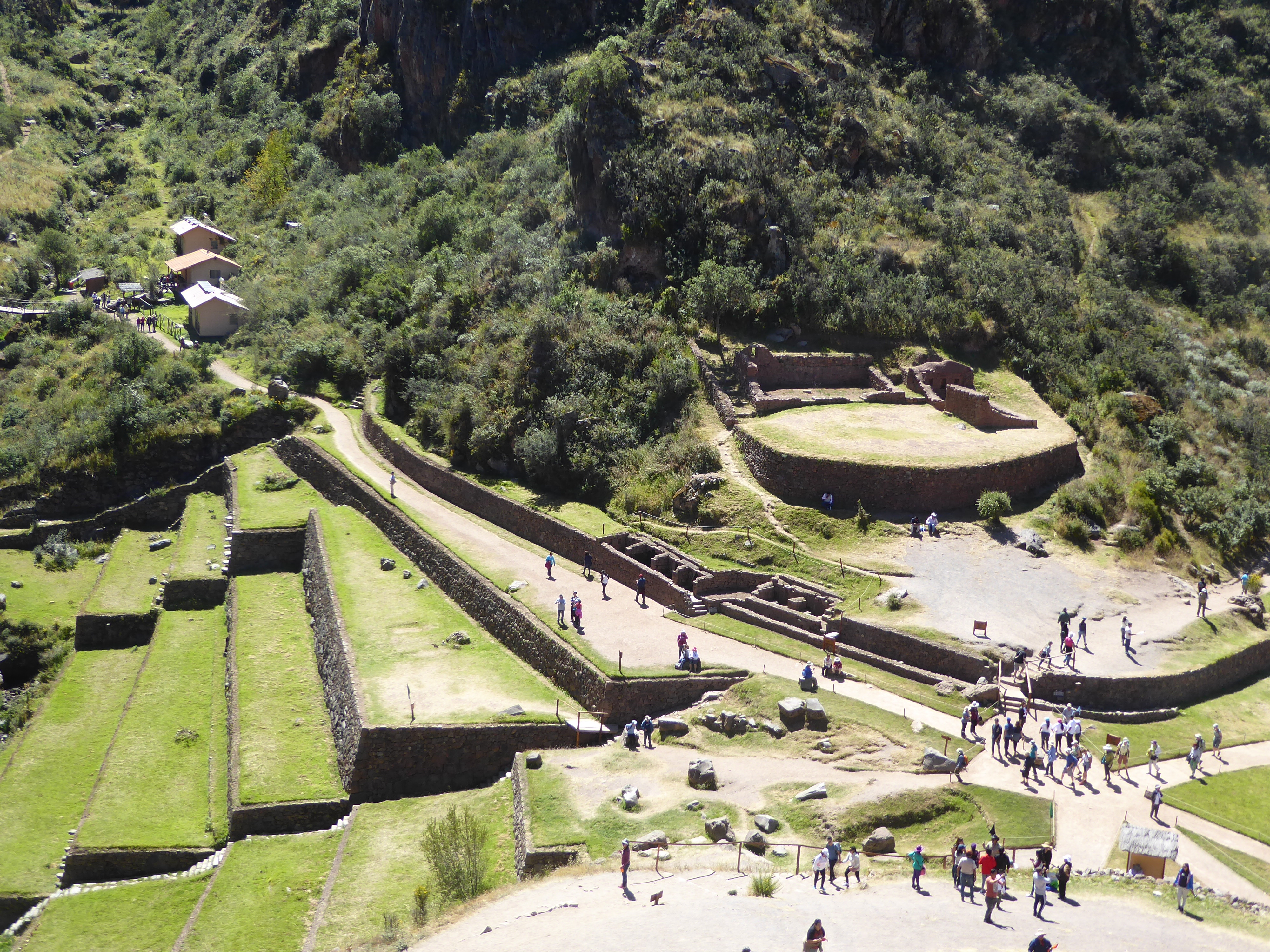
Breaktime's over: we're back on the ridge, but this time we'll stop at that parking place at the bottom of the terraces, and we'll walk along the path at their base.
We're at the base of those terraces now. You can see the path rounding a bend and heading toward the set of terraces we saw when arriving yesterday—the ones that extended to the very edge of a cliff. You can even see the houses of P'isaca, the cluster of ruins that are thought to have been Pachacutec's hideaway or, less flippantly, the elite quarter.
The view to the right. We were up top yesterday.
Watch your step.
P'isaca and its terraces. See the realtor's ad? "Spectacular views; needs updating."
Disappointed that the rulers of the Inca Empire didn't live in great palaces? They just didn't. Here's a careful description of Inca housing for all social classes: "Inca architecture, like most other great architectural styles, had its roots in the homes of its peasants, and, without some attention to this humble origin, it can never be properly understood. Indian houses in the Andes are generally one-room, rectangular buildings of fieldstone plastered with adobe, or of adobe entirely, or of sod, with one door and no windows, and with a thatch roof supported on gnarled poles cut from the mountain scrub. The thatched roof may be either gabled or hipped, and the houses have no chimneys. Ancient houses must have been very similar to these, an anyone who has visited Machu Picchu can attest. Even the most complex of Inca buildings in the finest masonry never became much more than a group of such houses, conveniently and usually rather regularly disposed within an enclosure wall....
"In the ideal rectangular plan, each square block was surrounded by a high enclosure wall with one entrance, and three or more rectangular houses were symmetrically placed around the sides of the compound so formed. It is this sort of a yard, enclosed with a high wall, and with room for men and animals to live inside, that was originally meant by the word cancha (kanca) in Quechua. Such an enclosure would house one or more families, depending on economic status, the buildings serving as sleeping and storage, with the kitchens perhaps in less permanent buildings, or at any rate, in a different building from that used for sleeping. The so-called Temple of the Sun in Cuzco, a dwelling of the gods patterned after the dwellings of men, had the enclosure type of plan and was very properly called Coricancha (Qori-kanca), "golden enclosure."
John Howland Rowe, An Introduction to the Archaeology of Cuzco, 1944, p. 24.
P'isaca from above.
And now, unexpectedly, we're climbing back up to the ridge crest.
Bingo. What is it?
How's this for fitting blocks to bedrock?
Or this?
Or this? When were those steps added? You can imagine the Inca disgust.
We still haven't figured out what this thing is.
See the central feature, that pointy central peg?
Here's the explanation from one author writing in the early 20th century: "A rock has been levelled at the top, giving an area, roughly circular, 18 feet by 16 ft. In the centre has been left, in the living rock, a cone-shaped pillar, 16 in. high. The whole is surrounded by a wall of stones, faced on the outside and perfectly smooth, about 20 feet high; this enclosure is shaped like a D. It is thought that the short pillar was surmounted at the proper season by a long gnomon..." (Vivien, Peru: Physical Features..., p 53).
And here's Squier: "The most interesting feature of this group of remains is the Inti-huatana; and as it is the best preserved of any of the similar contrivances of Peru—thanks to its almost inaccessible position—I will endeavor to explain it.... These inti-huatana seem to have always been formed out of a rock, the summit of which was carefully levelled or chiselled away, leaving only in its centre a projection very nearly of the shape and size of a truncated sugar load." "I was told by the Governor of Pisac, who accompanied me on my visit, that this column, or gnomon, was formerly surrounded by a flat ring of chumpe, or Peruvian bronze, several inches wide, which he had often seen when a boy" (p. 524-5).
You can't enter the enclosure now, nor touch the intihuatana. It's an understandable policy, but...
...what you can't touch you can zoom. What was the purpose of the intihuatana? Don't ask for a precise answer, but it presumably had something to do with noting the passage of the seasons.
What about the surrounding buildings?
Here's the so-called Moon Temple, a twin to the Sun Temple. Why two doors so close to another? So many questions; so few answers.
You remember some old professor commenting on the ability of Greek sculptors to carve cloth folds that appear to be soft? So check these corners.
Doorways here are tapered in two directions, both inward and laterally. The inward lean helps to resist the thrust of the thatched roof, which pushed down and out.
The lean of the jamb is not so easily explained, though it conforms to the trapezoidal form that is quintessential to Inca design.
The pegs are a bit of a puzzle. Such pegs are often used to anchor roof thatch, but in most if not all such cases the pegs are on the outside of the building. Gasparini has a photograph of such external pegs, and he observes that they "may have its antecedents in the projecting timber that rural houses still have" (Inca Architecture, p. 313-315).
How's this for an exuberant protuberance?
Amazingly to anyone who's walked out here, the Inca managed to bring water here; it's hard to see where it's coming from or going to.
Its path is almost whimsical.
A final shot.
You just have to live with the company.
Spot the Americans?