Time for another look-see, this time running around Cape Manuel and continuing out to Fann before circling back to Medina and the Bel Air cemetery. Too far to walk.
Gorée Island in the distance; Dakar harbor to the left; Cap Manuel to the right.
The beach was probably cleaner in years past. The road is the East Corniche.
Gorée again, along with the breakwater. Much of this strip, though a prized location, is inaccessible with rubble and trash.
Some is dedicated to old defensive works.
Here's a bit of sand. This whole strip between the breakwater and Cape Manuel is Bernard Bay.
We're as close as we can get to Cape Manuel: military beyond. Looking for a concise description? Can't beat the U.S. Hydrographic Office's East Atlantic Pilot, 1920, p. 59: "From Almadi ledge [a point to the north] Cape Manuel bears about S. 51 degrees E. (S. 31 degrees E. mag.), distant 8 miles. The intervening shore is high, covered with trees, and generally terminates at the seaside in basaltic cliffs or rocks. In a few places the cliffs descend into small bays, with beaches of white sand. The cape is high, covered with thick brushwood, and steep-to on its south side...." That's for sure.
The first light at the Phare du Cap Manuel was lit in 1867, when the Messageries Impériales, later the Messageries Maritimes, began monthly service between Bordeaux and Rio de Janeiro. It was a logical stop: Dakar is almost exactly 2,500 miles from each. Until then, the company's ships stopped in the Cape Verde Islands.
P.S. The company was one of the ancestors of today's monster shipping company, CMA CGM.
The French built a fort at the point, and some of its old buildings are accessible.
Much later the government built this huge, Corbusian courthouse, abandoned as structurally unsafe in 1998.
The thing had only been opened in 1956, three years before the French left. Makes you wonder if the British-built Hong Kong Airport, built in the last days of British rule, will prove any sturdier.
Yes, the atmosphere in January is gritty, but the location is so prime—a mile south of the Place de l'Indépendance—that somebody has done a deal and got rights to build.
The view north. The Cape Verde Peninsula extends northwesterly for almost ten miles before making a nearly right-angle turn and heading back to the prevailing coastline.
The outstanding building in this part of the city is the Pasteur Institute, set up first at Saint-Louis in 1896 by Emile Marchoux. The Institute worked on malaria, then sleeping sickness, then smallpox before moving to Dakar in 1913 and beginning work on rabies and plague. In 1924 Dr. Constant Mathis arrived from Cambodia. It must have been a solemn moment for him, because his own father, a naval doctor, had died of yellow fever in Saint-Louis in 1878. The Institute developed, and in 1934 for the first time used, a vaccine for yellow fever. Three thousand European volunteers got the jab.
A plaque on the building.
Here's the nearby Gynecological and Obstetrical Clinic, now the Hôpital Aristide Le Dantec. The style nods toward the Sudanese architecture of Mali. The French made this kind of stylistic accommodation in many places across their empire—Hanoi, for example—as, for that matter, did the British in India with their Indo-Saracenic style.
We've come a mile up the coast and are looking back toward Cape Manuel, which is well beyond the unnamed point shown here. Where there's a beach, there's somebody enjoying it. Where's there's a place to dump stuff, somebody's done that, too.
The coast isn't always so easy to use, and three miles farther up the coast, some fishermen are truly determined. Walking out there isn't as easy as it looks.
It's a spectacular location, which is probably why it was chosen for the Place du Souvenir, a massive monument to the 1,863 people who in 2002 died when the ferry Le Joola capsized on its way to Dakar from Ziguinchor, the main city of Casamance, on the other side of The Gambia.
The axis of the monument points to a map of Africa.
What can you say?
Viewers are supposed to behave and not go wandering.
Just a bit further and we arrive at the city's top hotel. The electronically controlled bollards whisper of the need for security. Is it a coincidence that the hotel is across the street from the home of the country's first president, Léopold Senghor?
We're walking inland past Senghor's house on Rue Leo Frobenius, named for a German anthropologist admired by Senghor. This is the city's diplomatic quarter.
Some houses aren't walled off completely.
Others enjoy their privacy.
Some insist on it.
Keep walking inland and you approach the contemporary city, spread-out enough to require highways and overpasses. The advertisements include one for bouillon cubes; the brand (Jongué) is a local word designating an elegant woman who knows how to cook.
She works for a living. Do you expect her to cook from scratch?
Meanwhile, construction crews do things the hard way.
Élysée Reclus, everybody's favorite 19th century French geographer, wrote that Dakar was one of the region's "extremely unhealthy places, exposed to dangerous miasmas and endemic marsh fevers of a virulent type."
He was right: an outbreak of bubonic plague in 1914-15 killed 3,653 of the city's 26,000 residents. The French decided to retreat to Plateau and simultaneously create a quartier indigène for the Senegalese. It was called Medina, was laid out on a perfect grid, and kept apart from Dakar Proper and Plateau by a 900-meter-wide buffer on which only a racecourse and stadium were suffered to exist. By 1940, half of the city's 100,000 people lived here.
With the Britannica-sized The Earth and its Inhabitants(English trans. 1888), Reclus was right up there with Alexander Dumas, at least by word count. The quote above comes from the volume on West Africa, p. 156. In the same place, Reclus writes that Dakar has Senegal's central "Government buildings, the barracks, and head offices of the trading companies; here is the terminus of the Saint-Louis railway, as well as of the Atlantic cable, and hither the population continue to migrate from Gorée. A first-class lighthouse stands on one of the crests of Cape Verd, and other improvements have been undertaken; but much remains to be done, especially in completing the harbour works, before Dakar can hope to replace Saint-Louis as the capital of the French Senegambian possessions." One imagines a wise observer whispering, "All in good time, all in good time." The view here is of Medina's main street, Avenue Blaise Diagne. Diagne (1872-1934) was mayor of Dakar and is perhaps even better remembered as the first African elected to the French Chamber of Deputies. That was in 1914. His name was the natural choice for the main street of Dakar's quartier indigène.
On the same street, and in the same Sudanese style as the gynecological hospital, the French built the Institute of Social Hygiene. The implication is that Africans needed instruction more than the French.
In A Dakar Childhood, Nafissatou Diallo writes of the Medina of about 1950. The place "consisted of huts and shacks, sometimes chaotically grouped together, through which ran narrow sandy streets swarming with people and domestic animals." (Diallo, p. 1; also quoted by Bigon, p. 230.) Seventy-five years later, the streets are paved and shacks are hard to find. Swarming chaos? That would probably be an exaggeration, but there's something to it.
Streetside shop.
Streetside furniture manufacturer. Space still seems to be at a premium.
There's room for a grand mosque, however. It was begun in 1937 and inaugurated in 1964. The architect was the Belgian architect Collet, who had long worked under royal patronage in Morocco. Surprise: the style here emulates (that's a euphemism for "copies") the grand mosque in Fez.
Well, Catholic churches can be formulaic, too. Perhaps the odd thing is that a Moroccan-style mosque should be built here at all, since the historical relationship between Senegal and Morocco has not been entirely cordial. A Woloff proverb apparently runs, "If you meet a Moor and a viper at the same time, kill the Moor first." Quoted in Emil Lengyel, Dakar: Outpost of Two Hemispheres, 1940, p. 157.
Head east from Medina and before you fall into the water you'll come to a large industrial district including the Grands Moulins de Dakar. It processed its first shipment of wheat in 1952. Since then, bread has become part of the Senegalese diet. The mill exports flour to Mali and beyond. The owner, the Mimran Group, also works with sugar and has investments in Ivory Coast.
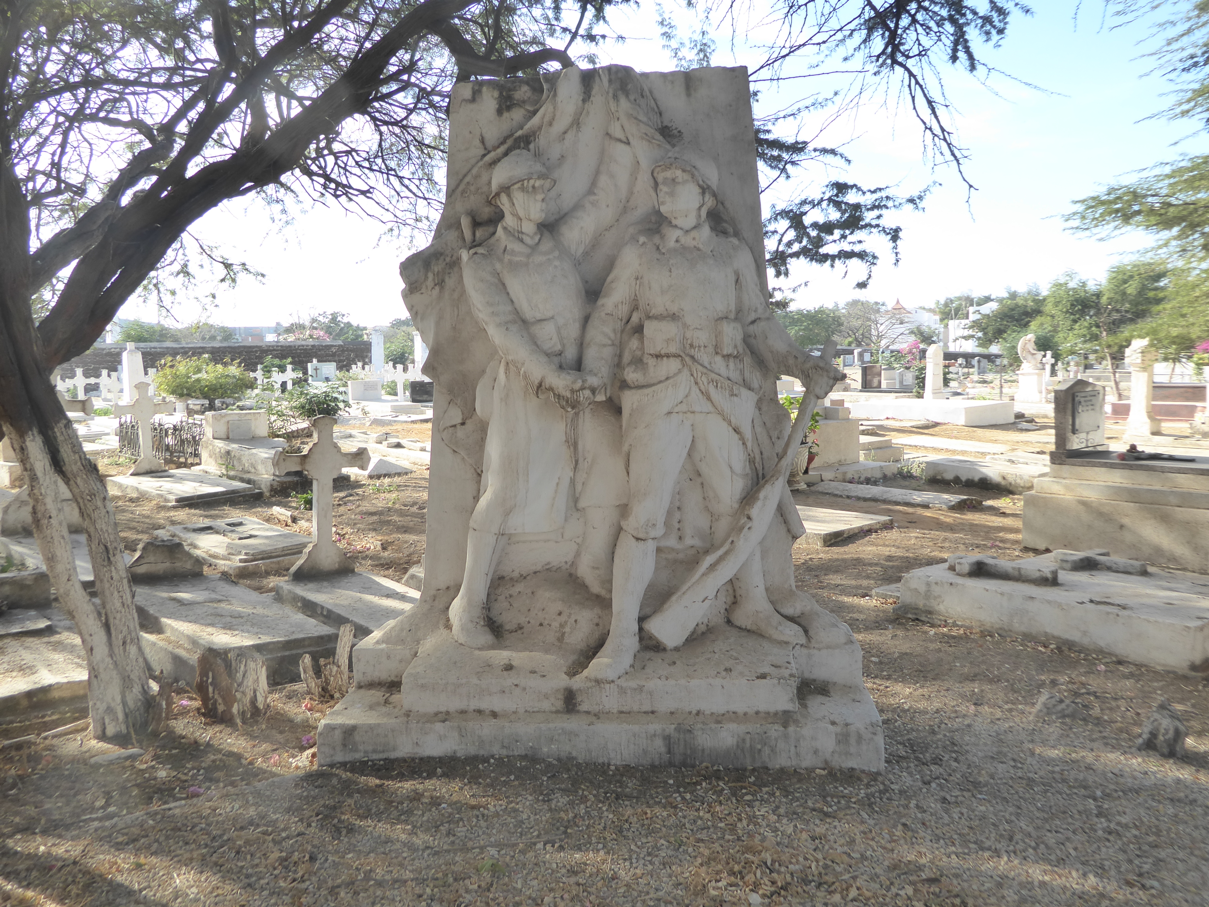
We didn't come out here to see factories, however. We're here for the Bel Air cemetery, just on the far side of the industrial district. The cemetery is older than Dakar and began with burials from Gorée, where space was too limited for a graveyard.
The French recruited heavily in Senegal for their armed forces and so were determined to honor them. What could be a more appropriate location than a cemetery?
Presumably this monument was moved here from somewhere else in the city.
Here's a substantial block commemmorating William Merlaud-Ponty (1866-1915), governor-general of AOF from 1908 to 1915.
Was there supposed to be something up top? Hard to say.
Rank and file.
An older bit.
The stone on the left recallas Rose Meissirel (neé Mathabon), who died on Gorée in 1853, before the French began developing Dakar. On the right is her husband, dead five years later at 56, "a good father, tender husband."
Dead at 17.
Oh, why not: dawn over Gorée.
Lest we seem too poetic, we might as well check the road out of town. Sigh. Good news: it was construction, not a wreck.