River mouths often make good locations for cities: think of Shanghai, Calcutta, New Orleans, or Buenos Aires. Africa's rivers are a disappointment, however. Yes, there's Alexandria, but there are no big cities at the mouths of the Niger or the Congo or the Orange or the Zambesi. The Senegal River is half an exception. The French set up shop here in 1659 on a small island. Smack in the middle of the Senegal River, the town of Saint-Louis became the capital not only of Senegal but of all French West Africa.
Late in the 19th century, Élysée Reclus, a geographer as famous as geographers ever get, wrote that "the French Senegambian possessions contain but one town worthy of the name, Saint-Louis, the capital...the most important coast-town for a space of 2,400 miles, from Rbat-Sla in Morocco to Freetown in Sierra-Leone (The Earth and Its Inhabitants, Africa: III, 1888, p. 157).
It sounds promising, but the coast here is sandy for thousands of miles, and the mouth of the river is no more than a break in the sand. Translation: there's a huge and forever shifting sandbar at the mouth of the river. Eventually the French moved their chief settlement down the coast to what became Dakar. That left Pierre Loti, writing in Le Roman d'un Spahi (1881), to say that Saint Louis "seems to be sleeping under the burning sun..." (quoted in Laura Bigon, A History of Urban Planning in Two West African Colonial Capitals, 2009, p. 113). In 1902 the French officially moved the headquarters of French West Africa to Dakar. Saint-Louis held on as capital of Senegal until 1958, when that function, too, moved to Dakar. A breath of life came in 2000, when UNESCO put Saint-Louis on its World Heritage list as a model of colonial town planning. Since then, many buildings have been renovated. Fishing is probably bigger than ever, which helps explain why the population has risen from 15,000 in the late 19th century to 75,000, mostly peripheral to the French town.
It will take us half a day to get there from Dakar, even though the road is fast for a while.
The freeway has been built not for Saint-Louis but for Dakar's when-will-it-ever-open new airport.
Things soon quiet down, except for the opportunistic traffic stop. "Let me see your watch." "No." "Will you give me a gift the next time you come?" "Peut-être." All in good humor, which is something.
Peanuts have been the big agricultural commodity here for a century. The load seems excessive, but all the trucks are loaded the same way.
There used to be a railroad between Saint-Louis and Dakar. The track's still there, in fact. Built by a private company, it was taken over by the government in 1933 and upgraded after termites polished off the wooden crossties. No luck: service stopped in the 1990s. The early details are recorded in one of the incomparable geographical handbooks published by British Naval Intelligence during World War II (French West Africa, II, p. 462).
Lots of upside-down baobabs along the way.
The Senegalese are as unimpressed by these trees as Iowans are by corn fields. Familiarity breeds etc.
Just another baobab.
Eagles seem to colonize particular trees.
Besides peanuts, don't forget manioc, another crop happy in dry soil.
Herds drift by.
Cars need refueling.
So do passengers.
A lot of people stick with water.
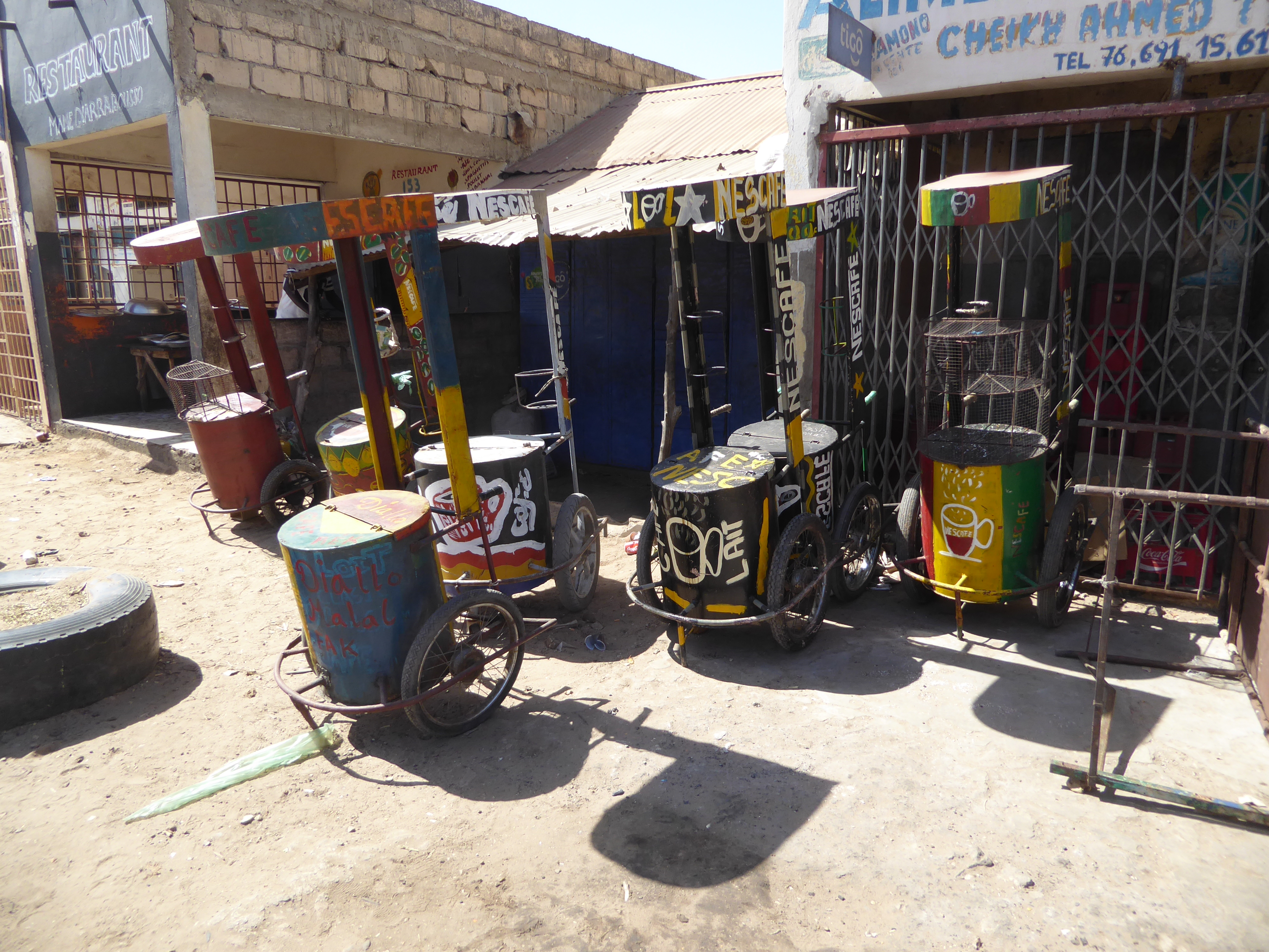
Well, not always: here are some coffee carts.
Village transport.
One bench seat and a small freight platform.
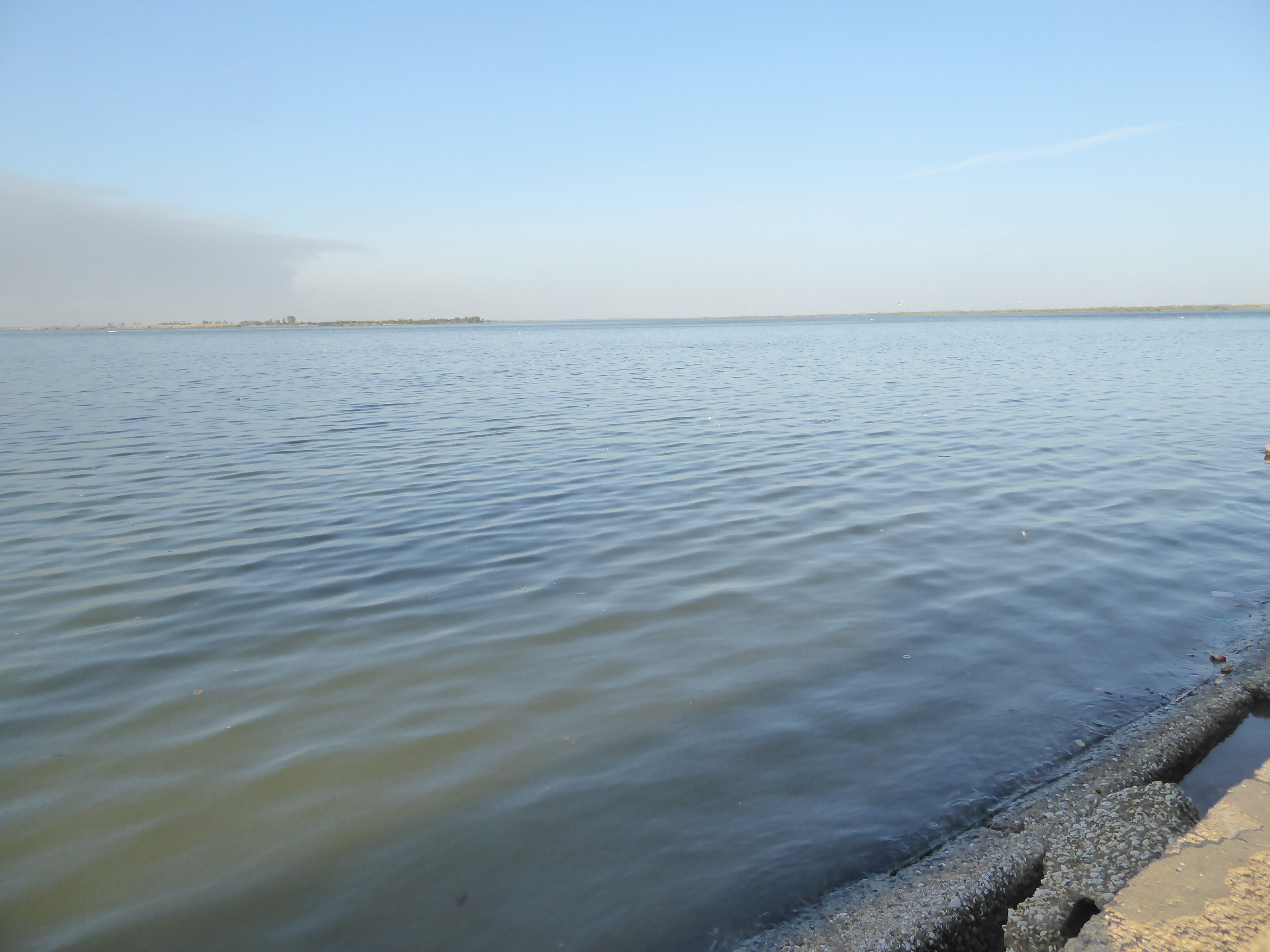
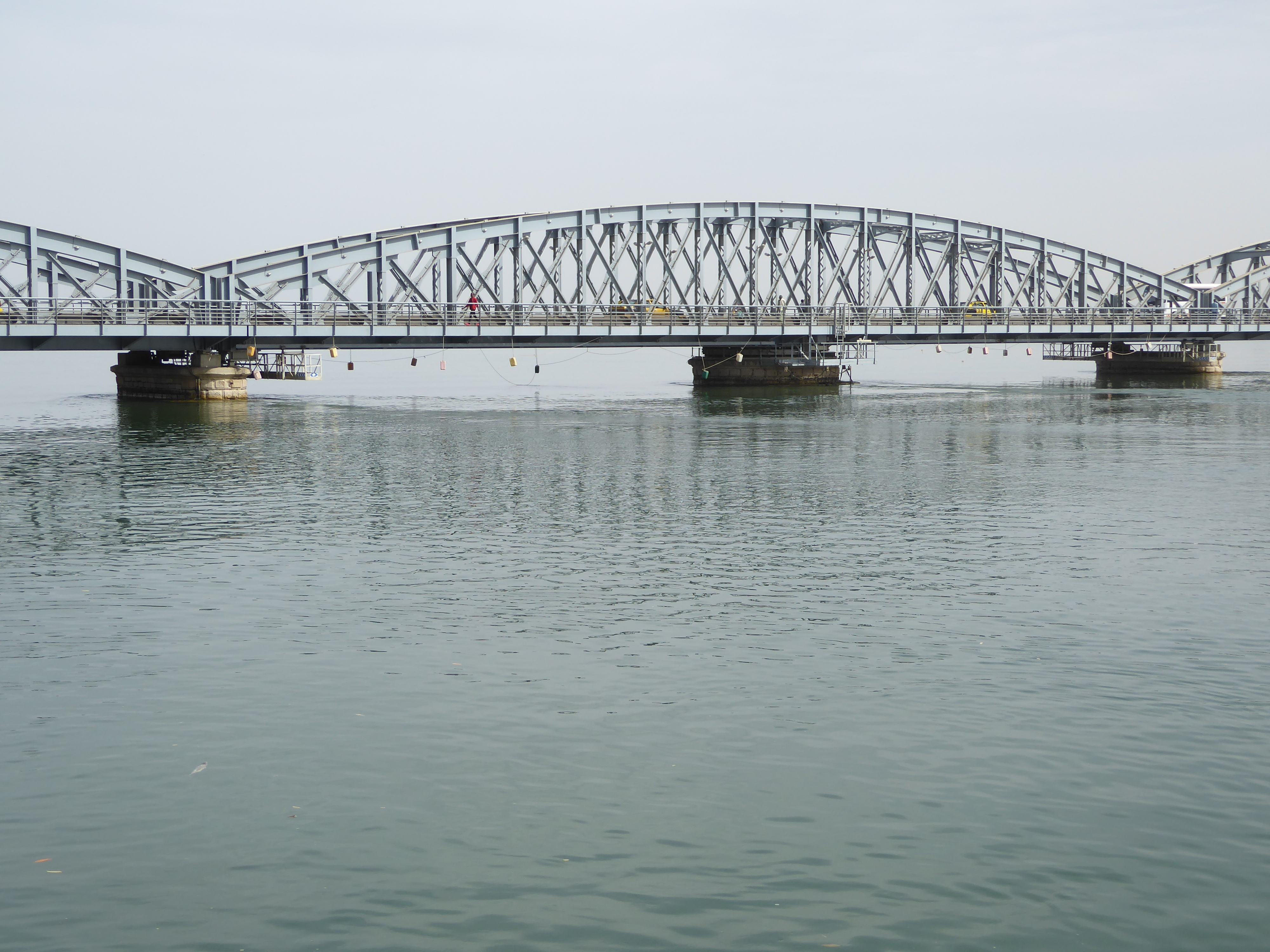
At last: the Senegal River, or more accurately the Grand Bras of the Senegal. Unable to reach the sea because of a seemingly endless spit, the river flows parallel to the coast for about 30 miles. Meanwhile, the current divides to surround the island that became Saint-Louis. It's here on the left and reached by the famous Pont Faidherbe, opened in 1897 and replacing a still earlier bridge of floating boats.
Louis Faidherbe (1818-1889) is a key figure in the history of colonial Senegal and served as governor in the 1850s and 60s. If the bridge looks awfully new, you're right to be suspicious.
The first Faidherbe bridge—six spans, 570 meters—was almost completely replaced with new beams and decking in 1933, and it was then entirely rebuilt in 2011. The design of the three Faidherbe bridges remained almost unchanged, however, so old photographs show a bridge much like this one.
Here's the view from the bridge toward the lower half of the island. The island is less than two miles long and only a few hundred meters wide. The river's mouth is about five miles downstream.
South Quay and Avenue Henry Jay border the Grand Bras downstream from the bridge. The building is typical, though the color is new.
We're at the south tip of the island and four miles from the open sea. That's the mainland on the left; on the right is Barbarie, the fishing community occupying part of the spit. Yes, the name refers to Berbers. And, yes, you'd better get used to trash.
Pirogues of every size and condition are tied up along the Petit Bras, on the west side of the island. That's still Barbarie in the distance; bridges link it to the island.
We've come up the north tip of the island and are looking once again to Barbarie. It extends north a few miles to the deserted border with Mauritania. From there, sand extends almost without interruption for over a hundred miles to Nouamghar and the headland at Cape Timirist.
We haven't moved, but now we're looking upstream on the main course of the river. Pity about the sandbar at the river's mouth, because the Senegal is navigable by river steamers upstream for 603 miles to Kayes, in Mali. A few miles beyond that, a small waterfall called Félou blocked further navigation, which is why, before there was a railway from Saint-Louis to Dakar, there was one from Kayes east, eventually running 308 miles to Bamako on the Niger. Eventually, track was also extended west from Kayes to Dakar, which more or less put an end to navigation on the Senegal. The waterfall was replaced in 1920 by a dam and power station.
Here's the first building seen by anyone coming off the Faidherbe Bridge—and also one of the last built before Independence. It's the post office, proof if any was needed that the French are always alert to style.
Across the street, there's this more typical colonial building: two stories, flat parapet, with wrap-around balconies, louvered doors above, and stout plank ones below.
Here's a weightier version, handsomely renovated and perhaps still a private house. Streets on the island are tightly gridded.
Vermilion is a recent addition to the Hotel La Maison Rose.
Not so the Bougainvillea.
Spectacular?
Without Bougainvillea, the streets can look pretty drab, despite the balconies. The building on the right and beyond the restaurant was a Moroccan trader's home but was restored after 2004 as a small hotel.
View from its balcony. The paintings speak to the island's reliance on tourist dollars.
A neighborly view.
Streets don't clean themselves.
Courtyard of the same building, renovated after a century of occupation by the Dioury and Hamoudi families, natives of Fez.
Traditional colonial materials.
The view here slices across the island's waist. Behind the camera is a bridge to Barberie. Straight ahead is the Governor's palace; beyond it is the post office and the bridge to the mainland. It's all very Cartesian. The park is the Place Faidherbe, though back in the 1940s it was the Place Petain.
Faidherbe himself is laden with Christmas lights.
No respect!
Kepi in hand, Faidherbe lived to fight in (and survive by twenty years) the Franco-Prussian War. Lucky guy.
If this were an ex-British colony, the statue would have been hauled off and dumped someplace out of the way. Not in Senegal.
The garden was presumably far greener in 1900. How it was watered then is a nice question. There are a few wells on the island, but additional water has to be brought some distance, because the river here is brackish, with tidal influence extending hundreds of miles upstream. Solution: the Faidherbe bridge carries a water main.
La Gaouvernance, formerly the Hôtel du Gouvernement, was built in the late 19th century on the site of a fort built by the French in the 17th century. The gate's closed now, but old photos show a trio of governors (Van Vollenhoven, Lacroix, and Merlaud-Ponty) standing in front of it, all under immaculate pith helmets. The gates themselves, as well as the fence, have been replaced, though not improved.
Somebody's keeping up with the gardening.
Two paired barracks, built between 1830 and 1843, line the old park. This one is the Caserne Rogniat (nord), named for Joseph Rogniat, a general here in the 1820s. He went on to grander things, which is why his name is inscribed in Paris on the Arc de Triomphe.
The building is now the Le Rogniat Hotel.
The courthouse has a fresh coat of paint.
The offices of the Commander of the Northern Zone aren't in such good shape.
Entrance to the Commander's house.
Fronting on the river just south of the governor's palace, this building housed the Conseil General du Senegal from 1887 to 1920, then the Territorial Assembly until 1952 and the Legislative Assembly until 1958. The interior is reputedly very grand.
Here's the waterside facade.
The city hall is still happy with the 1950s.
Ironically, the most run-down government building houses the Ministry for Sustainability.
Is there an active economy? Sure. Here's a grocery store.
Voilà! Bon Maman, just like at Whole Foods.
Car sales.
Pharmacy.
A simpler market farther up the island, where the rent goes down. In the distance is the minaret of the Zawiya Tidiane or Tidjaniya sufi assembly.
Need to add minutes? Here's the place to do it on Jean Mermoz Boulevard, which hasn't seen irrigation in a long time.
Here's something stylish.
And here's the main church, L'Église Saint-Louis-en-l'Ile, begun in 1827 and the oldest church in West Africa. It would have been built earlier if the French Revolution hadn't come along and if the British hadn't seized the island between 1809 and 1817. Work got under way again with the arrival of the Sisters of St. Joseph of Cluny, led by Anne-Marie Javouhey (1779-1851), now sanctified.
That would be John 1:14: "And the word was made flesh."
Grand on the outside, modest inside.
Organ loft.
Six windows represent the qualities of Saint-Louis.
A plaque recalls Bishop Jean-Claude Duret, here from 1856 to 1873; the middle line identifies him as Préfet Apostolique du Senegal.
A later priest, Hyacinthe Jalabert, drowned in 1920 in a shipwreck in the Bay of Biscay.
Looks like another church, but this is the island's Grand Mosque, paid for by the colonial administration, which perhaps intended to hammer home the idea that Islam was not so unlike Christianity. Cleo Cantone writes, "The mosque of Saint-Louis could in fact easily be mistaken for a church: the double square minarets replace the square towers, the arches on the windows and arcades on the front veranda are pointed instead of semi-circular, and the towers are crowned by two small domes." (Making and Remaking Mosques in Senegal, 2012, p. 128).
Old photos show hundreds of worshippers prostrating themselves in front of a building lacked the blocking wall seen here. It's all very different now from what Pierre Loti saw. He wrote that "the mosques of Senegal every where are extremely simple, white walled enclosures, often open to the sky and with absolutely no architectural pretension" (Cantone, p. 112).
Door to the mosque.
The mosque has one of the few wells on the island, which perhaps explains the mosque's location.
Just north of the mosque (on the right, still looking like a church), is the French consulate and Institute Français.
In terrible shape, this was once the important Maison Maurel et Prom, property of a Bordelais company established by two cousins who came to Senegal in 1822. They went into the gum arabic and then the peanut-oil business. They later had a major hand in persuading the French government to send Louis Faidherbe to West Africa with orders to establish French rule. The company quit Senegal in 1914 but is still active in other countries, though now in petroleum instead of peanut oil.
Those are wooden carvings (bodies and heads mostly), tacked onto what was, from 1880, a company store.
More ruins.
Lots of decrepit buildings to choose from.
We've come back to the Grande Bras and a point on the North Quay, upstream from the bridge. Here's an author writing at the end of French rule. "In at least one respect the Senegal is unique among tropical African rivers, for it is the only one that affords uninterrupted passage from the coast deep into the interior. From St. Louis, the port at its mouth, it is navigable upstream for a distance of approximately 500 miles. However, the steamer season usually lasts only from July through October, the floodwater months. For the rest of the year small launches can normally ascend as far as Kayes, but larger vessels can get no farther than Podor. It was this serious seasonal curtailment of navigation that impelled the French to build the Dakar-Kayes railway link that now takes much of the upper Niger basin freight traffic." (George H.T. Kimble, Tropical Africa: Land and Livelihood, 1960, 1:436).
Kimble doesn't say who was running the ships, but here's the answer: the Senegal Shipping Company, or Messageries du Senegal, a company founded in 1857. In 1975, Georges Console bought the company's abandoned passenger ship and began running a tourist operation. The ship was reassigned in 1980 to run a ferry service between southern Senegal (the Casamance) and Sierra Leone but in 2005 came back to the Senegal and began weekly service up as far as Podor, about a hundred miles upstream.
It's called the Bou el Magdad, named for the colonial government's chief interpreter, Bou el Magdad (1826-80).
Stern.
Staterooms.
Builder's plate.
In case you're running how the ship got past the Pont Faiderbe, here's the answer: one of the seven spans pivots at the middle. It opened in 2005 to allow the ship to pass and resume its river trips.
How did the French ever got locomotives up to that first bit of track running east from Kayes? Answer: they imported in pieces, then reassembled, a steam-driven 20-ton crane fondly called the Grue a vapeur de vingt tonnes. It arrived in 1883 to hoist the locomotive onto a river boat. The contraption was retired in 1954.
It's a rare beastie.
Cylinders, pistons, and crackshaft on the right.
Here's the old Messageries warehouse, just back from the dock.
No whistles now.