South Africa becomes a post-apocalyptic tapestry of sparkling blue swimming pools and ungovernable feral zones. That's Kevin Bloom, in Ways of Staying (p. 53). The words apply especially well to the country's metropolis.
Here's where it begins, a bit under four miles west of downtown. It's the George Harrison Park. Not that George Harrison. This would be an Australian who in 1886 made the mistake of his life, selling for 10 pounds his mining claim—the first on what would become known worldwide as the Witwatersrand. What followed? Of Harrison nothing more seems to be known. Of the city that grew atop the Rand? Here's Keith Beavon, an expert on the subject: "For most of its short life the city has been characterised by greed and opportunism of the worst kind" (Johannesburg: The Making and Shaping of the City, 2004, p. xvii).
A hundred meters away, the manicuring stops, replaced by the "ridge of white waters." It's about 30 miles long and happens to be the watershed between the Vaal River to the south and the "great, green, greasy" Limpopo to the north. The name apparently derives from the literally white waters cascading off the rocks on rainy days. In 1886, the same year of Harrison's discovery of gold here, the reef was officially declared a "public diggings." By 1913, it produced 40 percent of the world's gold.
On the spot, an almost inaccessible abandoned shaft runs along the bedding plane.
We haven't gone anywhere. We just stepped out of the park for a look at Main Reef Road, which runs into the city as Commissioner Street, long the heart of the office-building district. The street began as a veld track appropriately called "Rough Street." It's still pretty ragged.
We've driven into town and are looking east on President Street. That's two blocks north of Commissioner. There was nothing here in 1886, but by 1892 there was a railroad to Capetown. By 1896 this was the biggest city in black Africa, with a population slightly over 100,000. Perhaps half were white. The city's come a long way since then, but some early buildings survive at this western end, punctuated by a couple of highrises, including the Southern Life tower, here billboarded before the World Cup in 2010.
The townsite was established on a triangle of land bounded by three farmsteads. By the 1890s the triangle had been subdivided into a street grid with hundreds of lots locally called "stands" and measuring 50 by 100 Cape feet. (The unit equals 12.396 English inches.) The view here is of Ntemi Piliso Street (formerly West Street).
The grid is broken by the short road called Diagonal Street, a relic of the western edge of the triangular townsite boundary.
Seen from a certain angle, there's still a frontier spaciousness. (The same time warp is much more powerful, by the way, in parts of Harare.)
An early example of architectural gravitas, here at the corner of Market and Kort. Dutch influence, seen here in the gable, would begin to decline with the British takeover in 1900.
Purged of Boer stylistic traditions, this is Rosenberg's Building, at the corner of Market and Diagonal.
Commissioner Street 50 years later had been almost completely rebuilt and rendered stupendously tedious. Beavon calls the neighborhood, "depending on which part of it you are in, either seedy or sterile" (p. xiii).
The view of the CBD from the none-too-regal Queen Elizabeth Drive as it passes over a wide set of railroad tracks.
The city's authorities do what they can to stamp out street life.
A few monuments break the monotony. Here's the barren Beyers Naude Square, formerly Harry Hofmeyr Garden. City Hall, from 1914, rises behind a war-memorial cenotaph from 1926. The peripatetic Duke of Connaught laid the city hall's foundation stone in 1910; the building now houses the offices of the Gauteng Legislature. (The province of Gauteng, roughly equivalent to greater Johannesburg, was created in 1994.)
An uncluttered view of the west facade.
This is what happens when a committee tries to write.
The east facade, with a corner of the Rissik Street post office on the right.
The city hall is massive.
We're back to the Rissik Street post office, finished in 1904. Brick and stone? Nope: brick on plastered brick.
A couple of blocks to the northeast is the supreme court, with a cornerstone from 1910 and a design by the public works department.
Whatever impression it made when new has been fairly obliterated by unbelievably tedious later buildings.
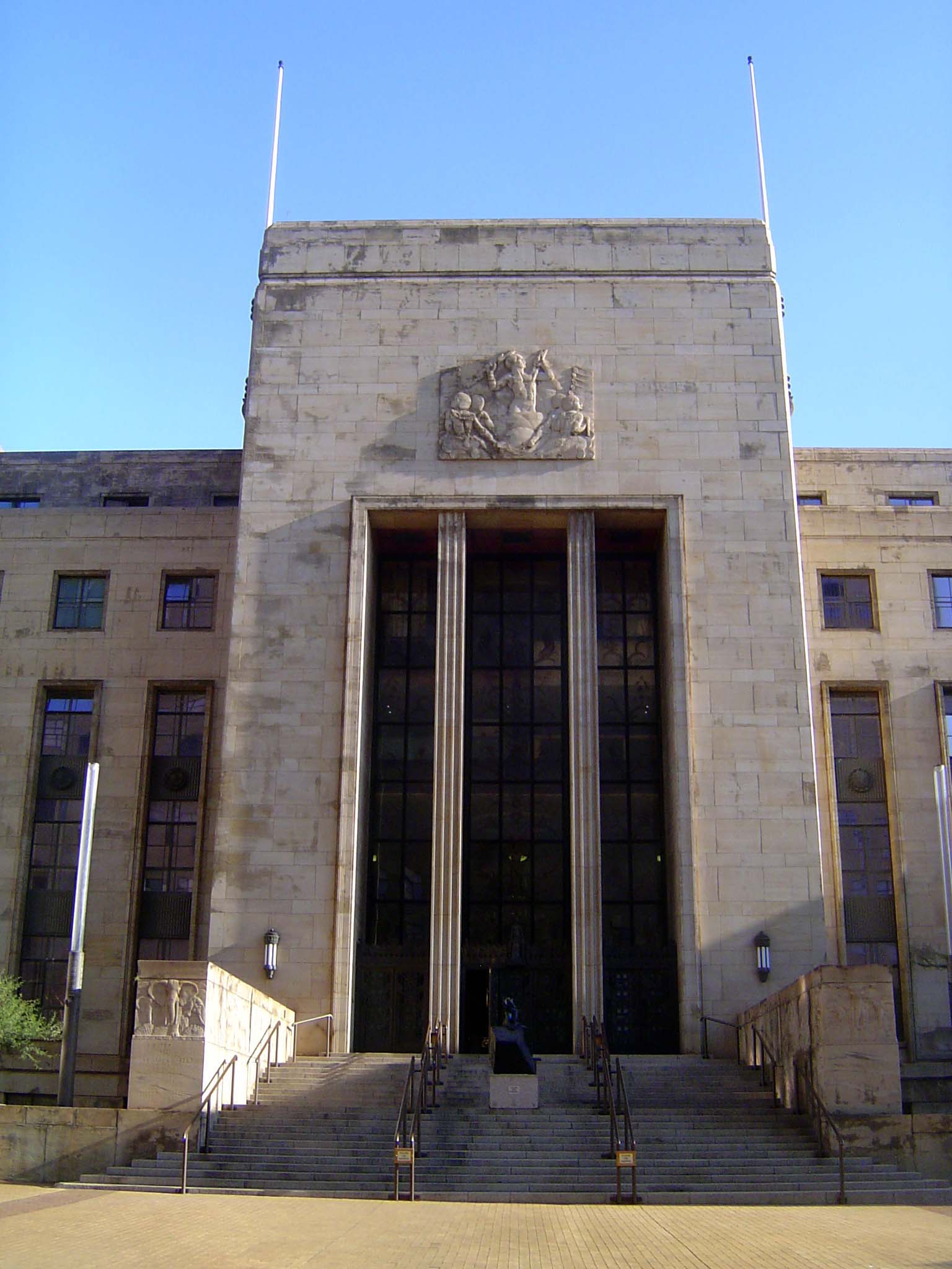
Park Station, the city's main railway station, takes its name from Kruger Park, a city park sacrificed to build the station. The cornerstone was laid in 1928, and the design was by Gordon Leith. Handsome as the elephants may seem, they're a shadow of what was originally intended: not heads but whole beasts under a barrel vault leading into the station. Notice the frieze above the elephants? We'll look closer.
The frieze shows the evolution of land transport, starting with porters.
Progressing to the wagons of the Boer trekkers.
And culminating, naturally, with a steam locomotive, circa 1930.
Farther along the facade, figures hold a medallion whose surface remains blank. One virulent critic writes, "For what inscriptions could a tired, deeply conservative Pact government summon up on its buildings during a world Depression? The building's face fails completely, inexcusably, to reflect the public scale of the great railway concourse behind. And here we encounter a heartbreaking discrepancy: on the one hand, the splendid terminal building that Leith had conjured up in his perspective drawings—with its majestic vaulted-arch clerestory and two giant pedestals to support national bronze sculpture of African elephants—and on the other hand, what was built: an insipid building, with three mean entrances, a crowded frieze and a relief of three disembodied, flattened elephant faces with outspread ears, sculpted by a local art teacher" (Clive M. Chipkin, Johannesburg Style: Architecture and Society, 1880-1960, p. 81).
Across the street, the Transvaal University College of 1908 was the first college in the city. In 1910 it became a school of mining and technology.
Its cornerstone. Selborne, the second earl, left South Africa just as the Union of South Africa was created in 1910.
Nearby is St. Mary's Cathedral, inaugurated in 1929.
The real power of the city lay in the mining companies and banks such as this one, the Standard Bank, whose building was designed by Stucke and Bannister and completed in 1908. Chipkin drops his virulence and praises this building as "...the high-water level of Edwardian classicism in Johannesburg, as witness the Ionic colonnades, Palladian windows, and classical domed roof pavillions" (p. 47).
The massive doors, suggesting piles of bullion to protect.
Another Standard Bank building, this by the partnership of Harrison and Fox.
The National Bank Building, 1903-04, by Leck & Emley. Now the First National Bank.
Entrance.
The same architects, Leck and Emley, designed the Rand Club building of 1904.
Despite the fact that the city was less than 20 years old, this was the club's third home.
The city's first skyscraper—complete with steel frame, concrete floors, and elevators with their own generators—was Commissioner Street's Corner House, built in 1903 for two deep-mining pioneers, Central Mining and Investment and Transvaal Consolidated Land and Exploration.
The Chamber of Mines has its own ideas about ornament.
And another.
Who are the giants today? Globally, they would certainly include BHP, whose Johannesburg office is perfectly anonymous.
Almost as modest, this is the headquarters of Anglo American, established by Ernest Oppenheimer in 1917. He was head of De Beers but turned to the East Rand and later to real estate and life insurance.
The building is from 1940 and was designed by Francis Lorne of Burnett, Tait & Lorne. Chipkin writes that the building "deliberately turns away from the high-rise skyscraper style that was fast becoming the accepted Johannesburg norm....[Instead it presents] an overwhelming sense of polite power and cultural worthiness. This low building, unnamed with English reticence, is the seat of finance capital in South Africa, and no signage is needed to inform you of this" (p. 128).
A detail—and as close as the building gets to a name. Could the elephant's leg be just a bit too thick?
Another detail.
Nearby, a headrig has been set up in Marshall Square to remember where the city came from.
It comes with historical displays.
Apparently, pachyderms are irresistable. Here, with space to let, is Elephant House, on Market Street at Kruis. Forget the columns. Look under the arch.
These particular elephants have a most peculiar anatomy, straight out of Babar.
Shopping? Sure. Here's Markham's, erected at Pritchard and Eloff in 1897, when the city was less than a decade old. The story is that the clock could be read a mile away. The building was much higher than anything around it.
The rooftop sign is original, but the ground-level ones replace a wraparound that read: "H.W. Markham, Outfitter & Clothier; Gentlemen's Complete Outfitter." For more, see Naomi and Reuben Musiker's Historical Dictionary of Greater Johannesburg (1999).
Across the street was a pioneer shoe store, Cuthbert's.
Cuthbert's turret was for a time leased as studio space to artists. Chipkin writes of its "wide-eaved corner turret with a steep roof cone surmounted by a roof lantern and flagmast. There is also a recessive theme of Edwardian classicism in the Ionic colonnade at attic-storey level..." (p. 47).
Across from Cuthberts is a store belonging to Africa's biggest supermarket chain. Shoprite has over 300 stores ranging as far as Ghana, Nigeria, Uganda, and Mauritius.
Thirsty? McDonald's occupies the former entrance of Stuttaford's, a defunct department store at Pritchard and Rissik.
Columns do seem almost as mandatory as tusked beasts.
Eventually the city's builders turned away from classical antiquity. Here, at Von Wielligh and Bree, is an apartment building in the Art Deco style localled called Empire Exhibition Style. The name comes from Johannesburg's Empire Exhibition of 1936, timed to celebrate the city's 50th birthday. (The Exhibition is discussed in a paper by Jennifer Robinson in the Journal of Southern African Studies, 29:3, Sept. 2003, pp. 759-789.)
Another example, from Main Street in Kenilworth.
And a third, in a Muslim neighborhood in the city's west end (Gerard Sekoto Street, formerly Becker).
Modern office towers eventually appeared, for example with the Stock Exchange building of 1984, designed by Helmut Jahn and developed by Anglo American. Chipkin writes that the building was "intended to become the precursor of the new financial development center to the west of the city. By this time, the property market and share market had slumped dramatically. The area became a mixture of first and third world economies, in which the Stock Exchange and financial institutions co-existed alongside street hawkers, dilapidated shops, warehouses, living apartment and empty spaces" (p. 105).
No flashy pretensions here: it's 1973's Southern Life Center.
The most important downtown development since 1970 is the Carlton Center, designed by Skidmore, Owings & Merrill and also opened in 1973. On the left is the Carlton Center proper, a 50-story office building now housing Transnet, the country's parastatal rail, ports, and pipelines company. The 600-room hotel to its right replaced an older hotel of the same name, built in 1904.
Undisclosed at the time of development, Carlton Center's main backers were Anglo American and South African Breweries, the two biggest companies in the country. For a while, the hotel was successful, but it could not resist the surrounding decline, and it closed in 1997.
A mall between the towers survives, though the gloomy entrance to the hotel—seen on the upper level in the distance—is chained shut.
Across the street from the Carlton Center, the Kine Centre opened in 1974. As a sign of a downtown in crisis, you can't do much better than this: the building sold in 2003 for less than a million dollars.
The entrance to Kine Center.
A few blocks north and rising behind the supreme court, the Tollman Tower on the left opened in 1970 to house the Johannesburg Sun hotel. This was the flagship property of Sol Kerzner's Sun International hotel chain, which had been established a year earlier as a partnership with South African Breweries. With downtown's decline, the hotel was demoted to a Holiday Inn, then, in 2001, to the Kwa Dukuza Egoli Hotel. That, too, closed. The ribbed building on the right is the Sanlam Center, from 1973, abandoned by that financial-services company and operating now as the Marble Towers.
Chipkin in a later book calls this apogee of highrise construction "the golden age of Wreckers Demolition Specialists.... For a decade Wreckers became Johannesburg's principal cultural event. When they demolished Gordon Leith's Surrey House and its neighbours, for the short-lived CNA headquarters building, they left a facade slither of the old Provincial Building as token to the past" (Johannesburg Transition: Architecture and Society. 1950-2000, 1997, p. 296).
Meanwhile, the northern suburbs do very well. Here, Westcliff Drive. A casual passerby might not even notice the electric fencing.
Security is more than a passing concern, however.
Walls and electric fences are standard.
Radio-controlled gates, too.
There's plenty of elegant variation.
Perhaps a tad penitentiaryish.
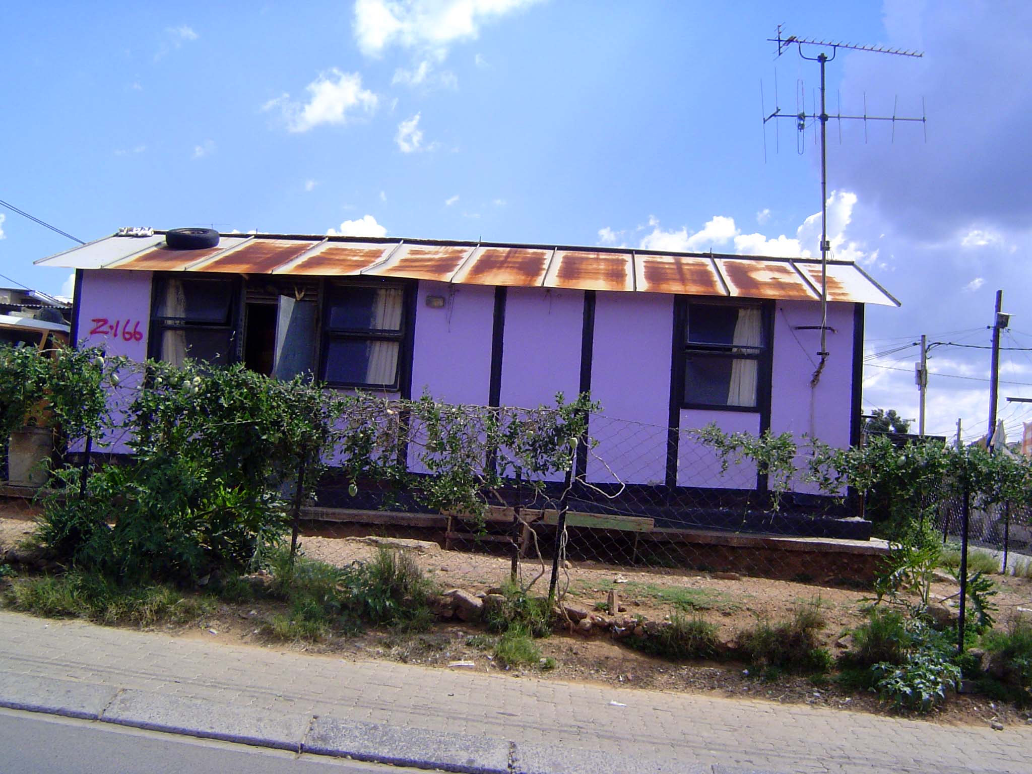
The other side of the tracks, so to speak. This is Alexandra, named in honor of Queen Alexandra, wife of Edward VII. Alternatively, or perhaps additionally, it was named for the wife of H.B. Papenfus, the developer who created the township in 1912 as an area where blacks and coloreds could buy freehold land. That right was abolished by the government of J.B. Hertzog, and Alexandra's homeowners became tenants of white landlords. Still, the place grew. It had 80,000 residents by the 1950s and 100,000 a decade later. The government then decreed that Alexandra would become a hostel town, and by 1973 thousands of homes had been demolished, their residents relocated mainly to Diepkloof. Alexandra's population declined to 90,000 by 1986, but the government had already agreed in 1979 to tolerate high-density family housing, and the township's population exploded to half a million in the 1990s. Unemployment ran at 60 to 80 percent.
Some of the hostels survive.
Some are better than others.
Some are being renovated.
Lots of homes survive from the township's first incarnation.
There are newer homes, too.
Row housing under construction in early 2010.
Another view.
And another.