Rather than navigate the tricky entrance to the embayed Harbor Creek, sailing ships arriving at Dar es Salaam in the late 19th century dropped anchor offshore. Yes, there was a town here. It had been planted by the Sultan of Zanzibar in 1862, and it had a tidy street grid, but thirty years later, Dar still had only about 5,000 residents.
German colonial power arrived in 1887 with big ships. They needed not only safe anchorage but docks. Dar was about to grow into a city.
An anchorage was developed approximately where the ships here are at anchor, which is to say between the two churches visible in this picture, the Catholic cathedral on the left and the tiled-roof Lutheran church on the right. Later, a deep-water port was developed still farther upstream. (For much more on the harbor, see Dar es Salaam, City, Port and Region, edited by J.E.G. Sutton, 1970, published as vol. 71 of Tanzania Notes and Records.)
Until about 1900, passengers came ashore in small boats and walked upstairs from the water's edge.
Shortly after 1900, docks appeared. Passengers continued to arrive this way until the 1950s and the shift to airlines.
A harbor jetty and crane were installed in 1905, the same year that the Germans began their East African railway. Like so many African railroads, this one was more a political statement than a paying proposition. The main exports in 1912 were groundnuts, cotton, cotton seed, and skins. Freight handling lagged behind Tanga, about 120 miles to the north and much closer to the bulk of European-owned farms in Tanganyika at that time. (For an account of one such farm and the career of a longtime colonist, see Werner Voigt's Sixty Years in East Africa, 1995.)
Old photos of the German-built railway station show that the space behind the arches was originally a covered porch, open to the street.
The railway platforms are very quiet today, with service suspended.
A rail-side warehouse, occasionally used by the UN's World Food Program.
Passengers arriving in colonial Dar had a choice of hotels, most of which have long since been demolished. Here's an exception. Despite the auto-parts signs, the design hints at the building's former use.
Just behind the trees and at the angle, there used to be large signs with the words New Palace Hotel. The streets here don't form a right angle, you'll notice, thanks to a grid-spoiling diagonal once called Windsor Street, now Indira Gandhi.
Directly across the street is this cafe. In the German period, it was called the Java Haus.
Take a look?
See the photos on the wall?
Tropical whites.
An officer.
Women join the group.
A more palatial venue: the DSM or Dar es Salaam Club. It must have been deeply resented, because within a year of Independence President Julius Nyerere signed a bill dissolving the club. The building is now a training institute for the ministry of tourism.
Colonial monuments have fared even worse. This one shows Hermann von Wissmann, a governor of German East Africa in the 1890s and the man who earlier suppressed a revolt. The statue was erected in 1911 and destroyed by the British almost immediately following their takeover.
The site remained empty for about a decade until the Commonwealth War Graves Commission commissioned this statue, the Askari Monument, dedicated to the Africans who fought alongside the British in World War I. (A mile from the site there's a War Graves cemetery, with dozens of well-cared-for graves for those men.) Placed in 1927, the statue stands at the intersection of Inglis, Acacia, and Windsor, now Maktaba, Samora Machel, and Indira Gandhi.
There's a cenotaph, too, also from 1927. It stands on a waterfront site once used for a memorial to Kaiser Wilhelm I. That memorial was destroyed, and the cenotaph hasn't done much better, losing the brass plate once bolted to it.
Churches have fared better, including this bit-of-Bavaria Lutheran church.
The building peeking over the right shoulder is the rebuilt New Africa Hotel, built on the site of the original New Africa, whose design was much like that of the New Palace Hotel. In the German period, the hotel was called the Kaiserhof.
The pews are indestructible, apart from their with woven-cane seats and backs.
The catholic church, St. Joseph's, was contributed by French missionaries.
The doors are works of art.
Latin inscriptions are almost hidden on the hinges.
Domus dei et porta coeli, "the home of God and entrance to heaven".
Quam dilecto tabernacula tua ("how splendid your tabernacle").
The British added an Anglican church.
It's almost devoid of the plaques that fill such churches in places where the British stayed longer.
One of the few plaques inside the church.
Some of the German government buildings survive, including this one, the High Court, later the Magistrate's Court. It's on the waterfront, just seaward from the Lutheran church.
The balcony is supported by ironwork.
A closeup.
The city hall and council chamber, another German leftover.
The post office was also built by the Germans, but the roof line has lost its original tiled gables, and the gray paint is somebody's idea of an improvement.
The British moved ponderously toward independence but in their later years provided a legislative assembly housed in a building paid for by a wealthy Indian merchant.
The entrance has this plaque. Twining, a former soldier who arrived here in 1949 from British North Borneo, was governor for nine years, an unusually long term. The DNB suggests that he wasted a great deal of time trying to carry out the Colonial Office's mandate of moving toward Independence while working to "entrench the position of the white minorities."
The legislative chamber.
On a wall, a lineup of local dignitaries.
The National Museum opened in 1940 and suggests that the culture of Tanganyika was dominantly Muslim.
How often colonial rulers deceive themselves.
Also on the museum grounds, a German lamp post.
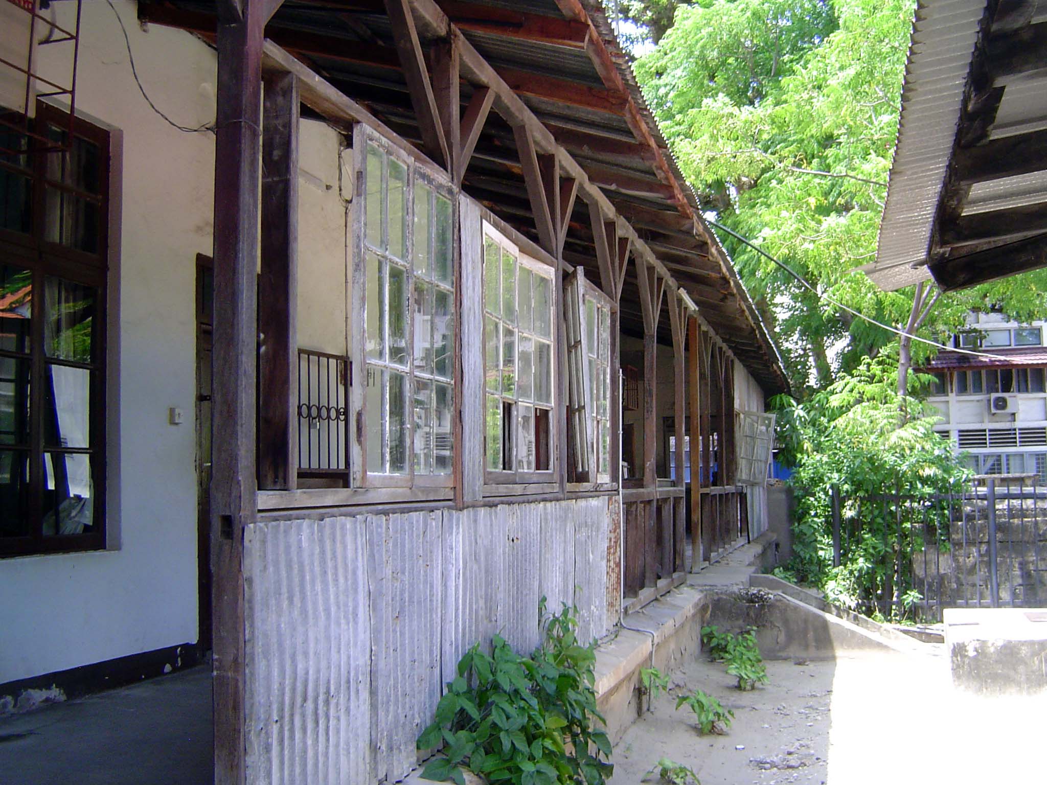
Behind the facades, many of these buildings are in rough shape. Let's take a look through that passage on the left. The building houses the Department of Lands and Surveys.
The far side of the passage opens here.
Hallway.
We're looking for a map of Dar es Salaam, but only an office copy can be found.
Meanwhile the German and the British city had a commercial district, its buildings hardly changed since the 1950s.
Here, a building dated 1931. Much of the neighborhood was built by Indian immigrants.
A later vintage.
The National Housing Corporation has a fondness for this color.
Blocks of Corporation flats line Nyerere Road, the main (and usually jammed) route into the city from the airport.
Something more stylish: Deco on Mosque Street.
It stands next to the effusive Darkhana Jama'at-Khana or prayer hall of the Ismaili Community, built in 1930.
Next to it is the Aga Khan Library and this, the Aga Khan's girl's school.