The author of Kampala's first town plan, A.E. Mirams, arrived in 1929 from India, where he had worked in Bombay as a consultant surveyor to the government. Did Mirams like Kampala? Good question. He wrote: "It is a town of seven hills, and is a strange mixture of the delightful and the hideous—glorious and entrancing scenery from splendid hill sides, over miles of valleys and open country, quite unsurpassed views of lake and hills, a town with many quite reasonably wide roads, and here and there a good building. On the other hand the valleys of death-dealing swamp, covered with papyrus and traversed by sluggish streams, brickfields and 'borrow' pits like ulcerous growths, corrugated iron shanties and sheds used both as shops and living places, with the entrails and skeletons of abandoned motor cars and other debris scattered all over the bazaar area, present a very different picture. It is by these and other signs that one is made to realise how terrible are the ravages created when our so-called civilisation forces its way uncontrolled into the heart of a new country." (Kampala: Report on the Town Planning and Development of., 1930, p. 3).
Mirams was writing about a town of fewer than 8,000 people. By the time the British quit in 1962, it had risen to 47,000. Fifty years later, in 2011, the population was officially estimated at 1.6 million. Any guesses what Mirams would say?
We can begin with the best. That would be the breathtaking huts built by the Baganda. Now these huts are vanishingly rare, but Sir Albert Cook, a Cambridge-educated physician sent to Uganda by the Church Missionary Society in 1896, recalled that "when we arrived in the country there was not a single building that was not thatched; the floors were beaten mud, the walls of reeds and palm poles or at best of wattle and daub" (Uganda Memories, 1949, p. 370). This hut is on the grounds of the National Museum.
It sounds as though Cook wasn't too impressed, but that's probably the wrong conclusion to draw. Elsewhere in the same book, he writes that "largely hidden by the [banana] trees were many native huts of the familiar beehive shape, constructed on a basket work of palm poles and reeds, devoid of windows but with a large doorway and a thatch most neatly put on and extending down to the ground. In the better classes the inside was kept scrupulously clean, the stamped mud floor being carpeted with dry sweet smelling grass arranged with the stalks laid parallel. A fireplace was formed of four palm poles placed in a square of three or four feet each way: the smoke was allowed to make its way out through the thatch. The interior of the hut was divided into three or more rooms by hanging bark cloth curtains" (Cook, p. 44).
This hut is the gatehouse of the Kasubi Tombs, a World Heritage Site.
The domed ceiling in this case has split reeds under the thatch and supporting coils of spear grass or split palm fronds bound with woven string and supported by a framework of poles above the reeds.
Exposed poles like these were normally wrapped in bark cloth. Planted half a meter into the ground, they were set in circles. All the pole work was done by the leopard (Ngo) clan, one of 51 Baganda clans.
Only the lowest bundles of thatch were tied to the rings; higher ones rested unattached and could be removed when decayed. The lowest bundles were laid with the stems down; higher layers were laid with the stems up and were applied until the thatch was a foot thick. The work was done exclusively by the colobus-monkey (Ngeye) clan.
There's a photo in Cook's Uganda Memories that shows him as a young man at leisure in his Kampala home. He wears a suit and tie and sits on a folding chair at a table with teapot and cups. The house itself, however, is just like this one. So was Cook's first hospital, which opened in 1897 and was thatched, though the floor plan was a long rectangle and the thatch did not come to the ground; instead, the walls were split reeds that allowed some ventilation. Three years later, Cook built a replacement hospital with solid walls of whitewashed mud and wattle. It had windows, too, but the building was roofed with 112 tons of trimmed thatch. Two years later, a lightning strike destroyed it, and a third hospital went up, this one without thatch and instead with sun-dried brick under an overhanging roof of corrugated metal on sun-dried brick. So did the Baganda hut begin its long decline and eventual near-disappearance.
A sad story. This traditional hut burned in 2010. It was no ordinary hut: at Kasubi, it housed the tombs of four Baganda kabakas or kings. It was, and is, a UNESCO World Heritage Site, but it's being rebuilt with a steel frame coated with fireproof paint. Not very authentic, but it replaces a hut that was built in 1938 with concrete poles. An earlier hut had been built in 1882 by the 35th kabaka, and it replaced one from 1820, so perhaps we shouldn't expect these buildings to last for centuries—or to expect even this one to resist fire. Guides on the spot have no hesitation in assigning blame for this fire. They say it was the work of the same Somali group responsible for suicide bombings in Kampala that year.
Fourteen years after John Speke arrived in search of the source of the Nile—and a year after Henry Morton Stanley's visit—the Church Missionary Society arrived in Kampala. It was 1876. The kabaka allotted the missionaries Namirembe Hill, a mile from his own palace. Albert Cook, the medical missionary had not yet arrived, but in his memoirs he has a photo of the first church built on the site. It looks like a giant squared-off haystack, about 80 feet on a side. Cook writes that it was "blown down" in 1894. A brick replacement was built in 1901, but it had a thatch roof and burned in 1910. The result was this, the third Namirembe church, a cathedral consecrated in 1919. Mirams, the planner, noted in 1930 that "it is unfortunate that a good close up of this building cannot be obtained since it occupies all of the summit of a steep hill" (p. 12). That's still the case, though you can find good air photos.
Anglicans weren't alone. Here's a mural on a wall in the huge Rubaga Cathedral. It shows the arrival of the White Fathers, a Catholic order based in Algiers. ("Rubaga" is pronounced with an L, not an R.)
The White Fathers arrived in 1878 but did not finish their grand church until 1925. It was designed by a lay brother. Clocks were never installed in the towers, though spaces were left for them. Like Namirembe, Rubaga is close to the royal palace. Perhaps the kabaka wanted to keep a close eye on these newcomers.
The missionaries weren't the only Europeans interested in Uganda. In 1890 the British East Africa Company sent Frederick Lugard to establish a fort in Kampala. He did so, and Uganda became a British protectorate five years later. Here in the national museum, a bronze George V stands, looking as though he's being held up at the LHR immigration hall. "Cloke, crown, sword.. and still they keep me waiting."
Lugard built a stockade of makindu palms. They were replaced the next year by a more substantial wall, but as early as 1930 Mirams would write that "little more than the remains of the walls can be seen today." Lugard also built himself a temple-fronted office in the fort. Think this is it?
Sorry to disappoint: it's a replica, though of the form and size of the original.
The fort stood atop the hill soon known as Old Kampala. Mirams wrote that "the upper part of Old Kampala should be retained and laid out as a park" (p. 132). For a while it was: Henry Kendall, a planner in the late days of British rule, wrote that "little of even the remains of the walls [of the fort] can be seen today, the area being preserved as a green open space, with sweeping, well-cut lawns and a deep ditch on the north and east." (Henry Kendall, Town Planning in Uganda, 1955, p. 19).
Even that's gone now, replaced by the national or Qaddafi Mosque, funded by you know who. In 2015 he remained a hero to many Ugandans who still had Pan-African dreams.
Time for economic development! In 1907, an ebullient Undersecretary of State for the Colonies named Winston Churchill arrived on an inspection visit. He shortly wrote: "Let me make my message brief and unclouded, and as before expressed in three words, 'Build a Railway.' Till then all civilized government is extravagant and precarious, and all profitable commerce practically impossible" (My African Journey, 1908, pp. 143-145.)
What was he complaining about? The British in 1901 had already opened the Uganda Railway from Mombasa to Port Florence (now Kisumu), on the eastern shore of Lake Victoria. From there, ferries crossed the lake in 12 hours to Entebbe. That's how Churchill arrived. Apparently he didn't like ferries. By 1929, however, the Uganda Railway had been extended round the north shore of Lake Victoria to Jinja, and a year later it crossed the Nile just below its outlet from the lake. That same year, the line reached Kampala, 756 miles from Mombasa. By the late 1950s the railroad had been extended still farther west to Kasese, 20 miles from the Belgian Congo. The British hoped that the line could be pushed another 300-plus miles to Stanleyville (now Kisangani) to create a rail-and-water route across equatorial Africa. It never happened.
From the colonial archives, here's Governor William Gowers speaking in 1929: Kampala should not be seen as the intended end of the line but "merely as a strategic point for further extensions... It has for many years been recognised that the ultimate objective of a line westward from the Coast must be the Congo, and the question is what part of the Congo. The answer can only be Stanleyville... which is obviously destined to become the main centre of communications in North Central Africa, of which the southern connection [from Cape Town] and the western connection to the Atlantic are already established" (Mirams, p. 111).
The Kampala station opened on February 20th, 1939, a decade after the first train. The station was described as "worthy to be the terminus of the great Kenya-Uganda Railway." Worried that you might miss your train because you can't see the time?
Don't be. There are no trains today, or tomorrow. Back in the day, mail trains ran between Mombasa and Kampala twice a week, leaving Mombasa at 4 p.m. on Sundays and Wednesdays. The 48-hour trip cost 10 pounds 8 shillings 90 pence in first class. An alternative, slower route ran to Port Florence (now Kisumu) and from there by ferry to Entebbe or Port Bell. Braver souls could journey up the Nile from Khartoum to Juba, then continue on a bus operated by the Sudan Government Railways to Nimule, where steamships provided by the Uganda Railway steamed to Butiaba on Lake Albert. From there, buses ran through Masindi to Lake Kyoga and the town of Namasagali, from which a train could be taken to Jinja. Amazing, isn't it?
Kampala in 1930 was still a small place, as this map from Mirams (volume two) suggests. The three ovals in the lower left mark the Anglican and Catholic churches along with the royal palace. Old Kampala is due north of the palace and looks rather like a candle flame. Kampala town lies to its east.
Close-up. Mirams calculated that Kamapala in 1930 had a total of 518 buildings, of which 208 belonged to the government and of which 142 were residential. Of the 310 private buildings, 252 were residential. There were also 23 workshops, 26 godowns, five factories and ginneries, and four mosques, temples, or churches (p. 73). It's hard to believe that such a tiny place would inspire Mirams to write about "the ravages created when our so-called civilisation forces its way uncontrolled into the heart of a new country."
The railway station does not yet exist, though there's a platform. There's also a downtown, centered on Main Street.
Here it is 85 years later, with a new name that reveals once again those never-say-die hopes for regional integration.
Idi Amin in 1972 evicted the Indians who dominated the economy, but he had no effect on the Indian-style of signposting, here still in classic form.
Mirams wrote that "now where you will, wherever we find roads, we meet groups of ugly corrugated iron buildings, used mostly as houses for residents, stores and shops... [W]hat were at one time quite pleasing native villages are rapidly becoming ugly, as well as really unsuitable, both from the point of view of trade, as well as living" (p. 75). He attempted to impose some order on the city. Here's a proposed cooperative-housing scheme.
And another.
Any residue? Not, apparently, from those pretty drawings, but how's this nice line of tidy housing on School Road, facing Kampala's Senior Secondary School and just down slope from Old Kampala? Wonder who lived here?
Wonder no more. By 1930, the year of Miram's plan, there were 3,000 Indians in Kampala, and the ring road around Old Kampala was designated for their use. Separate quarters had been urged for Asians as early as 1914, when W.J. Simpson of the London School of Hygiene and Tropical Medicine visited Kampala. He wrote in the next year that "it has to be recognized that the standards and mode of life of the Asiatic do not ordinarily consort with the European....." Simpson not only separated Asians from Europeans but excluded Africans altogether, confining them to Kibuga, on the southwestern fringe of the city. (Quote from "Planning of Kampala City 1903-1962: The Planning Ideas, Values, and Their Physical Expression," by Fredrick Omolo-Okalebo et al, Journal of Planning History, 9:3, 2010).
The British Secretary of State in 1923 overruled this policy and forbade formal segregation, but he also wrote that "in practice the different races will, by natural affinity, keep together in separate quarters" (Mirams, "Town Planning in Uganda," Journal of the Town Planning Institute, 19, 1931, p. 26).
A European house of the period. There's not a lot of renovation in Kampala; houses grow decrepit and are then demolished and replaced.
Still, well-surveyed plots survive even as the houses on them fall apart.
Pretty good shape: it's now a restaurant. The highrise behind it presumably replaced a one-story house.
Another vintage home, this one with plenty of space. Wonder where it is?
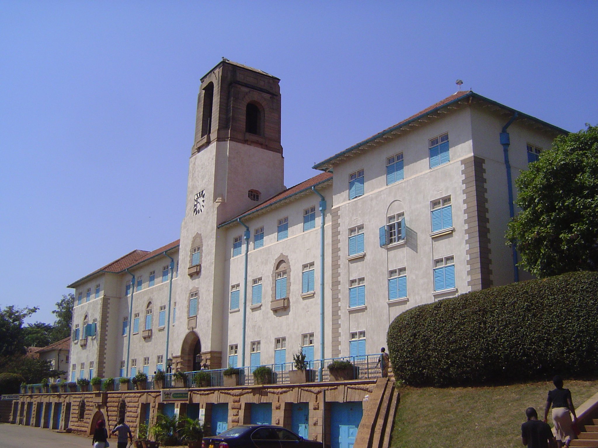
No problem: it's close to this, the main building of Makerere University, among the proudest British accomplishments in Uganda. The school opened in 1921 as the Uganda Technical College for the Training of African Artisans, but it soon expanded and began offering courses in medicine, agriculture, veterinary science, engineering, surveying, and education. A reference book from the 1930s notes that "the future visualized for Makerere College is that of an African University College meeting the comparatively limited demand for higher education for all the east African territories" (H.B. Thomas and Robert Scott, Uganda, 1935, p. 319).
When this main building was begun in 1938 the event attracted not only the governors of both Uganda and Kenya but the Duke of Gloucester, the king's brother. The first principal was a former headmaster of Marlborough College, a British boarding school.
Entrance with logo.
Inside: the Oxford motto transplanted.
Albert Cook, the medical missionary, posed a question that he must have considered rhetorical: "After all, what does the British Government want the African to become? A modern pagan with the ideals of business efficiency and money making?" (p. 391). In the decades that followed, the British went away, but the university continued to grow. The answer to Cook's question became as clear here as anywhere: you're darn right, though perhaps Christian to boot.
The main campus building was soon flanked by two chapels, one Catholic and the other Anglican. Both are busy on Sunday.
The two chapels are evenly matched.
Not enough seats inside.
Meanwhile Mirams anticipated the city's need for better roads. Here's his plan for the main road through the city: separated traffic lanes, a planted median, diagonal parking, and wide sidewalks.
The idea survives to the extent of plantings between the traffic lanes, but parking has shifted from the median to the margins.
In the last year of British rule, the Department of Lands and Surveys published its one and only edition of the Atlas of Uganda. A plate was dedicated to Kampala, and there we read that "the main street through the town is more than five miles long and is a dual carriageway for most of its length and as leases expire the early dukas [small, family-owned shops] are being replaced by fine modern buildings" (p. 76). As for fine, this furniture store is about as close as the buildings come to architectural pretension.
Mostly, the street is flanked by buildings like these. It's hard to imagine that the British considered them "fine," but the 1950s were a funny decade.
Gradually, the height of buildings along the street rose.
Airways House was built as the Uganda office of East African Airways, which operated from 1946 until 1977.
A few buildings qualify as high rises.
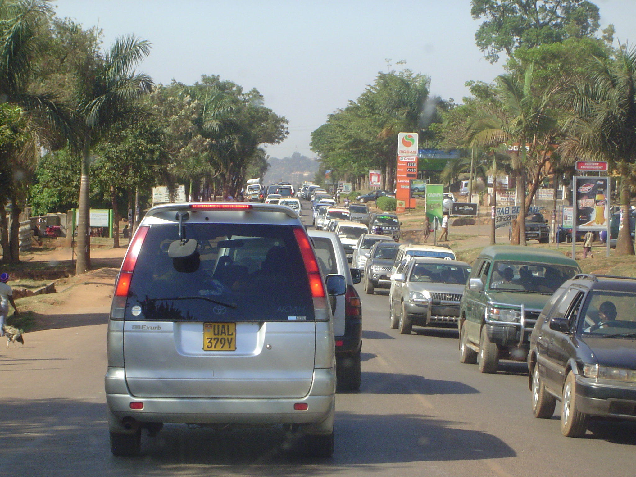
That's Uganda House on the left, built in 1980 and housing the Uganda People's Congress. The Cham Towers, on the right, were built in 1979 as a bank. The median has disappeared in this stretch of the street, which has turned into a six-lane highway.
The Cham Towers were built as the Uganda Commercial Bank, which was eventually sold to the Standard Bank of South Africa, which in turn sold the building to a local businessman, Karim Hirji, who renamed the building but gradually let it fall apart.
Uganda House seems in better shape.
Blank walls become billboards plastered ubiquitously with U.S.-funded signs urging HIV testing. Why is that USAID, like other development agencies, always lets you know who paid for its good works?
Meanwhile, the old nickname "Kampothole" is due for an update, perhaps to "Kamjam." Churchill had written: "The road from Entebbe to Kampala passes through delicious country. Along its whole length a double avenue of rubber trees has just been planted, and behind these on each side are broad strips of cotton plants, looking beautiful with their yellow flowers or pinky-white bolls" (p. 73).