Home UpOKC 2 Water, Rail, Road
A quick look at the Oklahoma River (really a seven-mile ponded stretch of the North Canadian, but we'll go with the non-flow) and at the transportation tangles—road and rail—that have wrapped downtown.<br/>
We're looking at the ponded river. The tributary is the arriving end of the man-made Bricktown canal. The building to its right is a boat house for sculls; the pyramids in the background are part of the Producer's Cooperative cottonseed-oil mill, which opened about 1900 and closed in 2015. The owners opened a mill 100 miles to the west, in Altus, and entered negotiations to sell their 27 acres here to investors who planned to build the entertainment stuff, plus a soccer stadium.
Here's the dam that creates the pond. It's at Eastern Avenue. Upstream, there are two other dams, one at Western and one at May.
And here's the river immediately downstream.
Here's the same streamcourse as of 1910, when the river regularly flooded. Most of the curves have been engineered away.
The view upstream from the overpass at the lowest of the dams.
Amenity riverfront.
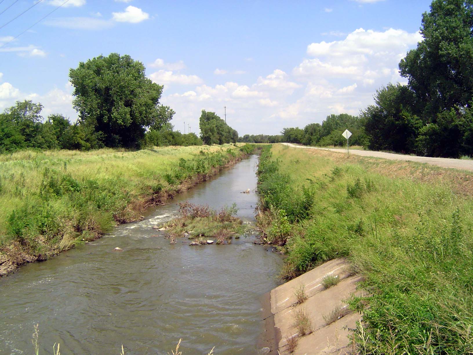
And here's the North Canadian less than 10 miles upstream. Until a few years ago, the Oklahoma River was as sporadic as the view here. Not that this picture represents the pristine river. What do you think is just upstream?
Voila! Another dam, this one creating Lake Overholser, the first of many reservoirs built to supply Oklahoma City with domestic water.
Lake Overholser covers 1,700 acres and was completed in 1918.
The reservoir site was a natural depression, as shown on the public-land survey map of the township.
A close-up.
The map is annotated to explain that the land had been reserved for the Army's use as a source of timber until it was released for settlement.
U.S. U.S. 66 crosses the northern end of the reservoir on this old cantilever bridge.
The growing city soon needed more water and contracted with the Corps of Engineers to take water from the upstream Fort Supply Reservoir. That, too, was insufficient, and in the 1940s a canal was built to divert water from Lake Overholser north into the watershed of the Cimarron, where another reservoir could be built on Bluff Creek. The federal government helped pay for it. Justification: flood control.
Here's the canal, heading north to that reservoir, Lake Hefner.
End of the canal, as water drifts into this second reservoir.
Another angle.
The lake at low stage.
Here's the reservoir as shown on a USGS topo sheet which shows in dramatic purple the city's rapid growth. Lake Overholser is off to the lower left.
A later edition, everything a nice pink but with lots of brave new housing just downstream from the dam.
The dam was finished in 1944; it's named for Judge Robert Hefner, Oklahoma City's mayor from 1939 to 1947.
Looking south from the dam across the reservoir. It may look like a lot of water, but the city long ago reached still farther afield and in 1968 began taking water from Lake Atoka, even though it's 100 miles away and requires lifting water 600 feet to raise it to the level of Lake Stanley Draper, a receiving reservoir on the southeast side of the city.
Looking from the dam north over Bluff Creek.
Homeowners immediately below the dam. Color them brave?
Enough hydromania. We're back downtown at the Santa Fe depot, from which Amtrak's Heartland Flyer goes back and forth daily to Fort Worth. The Santa Fe track was completed through Oklahoma in 1886, but this depot was built in the 1930s.
The train platforms are elevated on the left.
Although there's only one back-and-forth passenger train daily, the line, now part of the BNSF, is still very busy with freight. Since this photo was taken, Devon has moved to a new, much taller building, the city's highest.
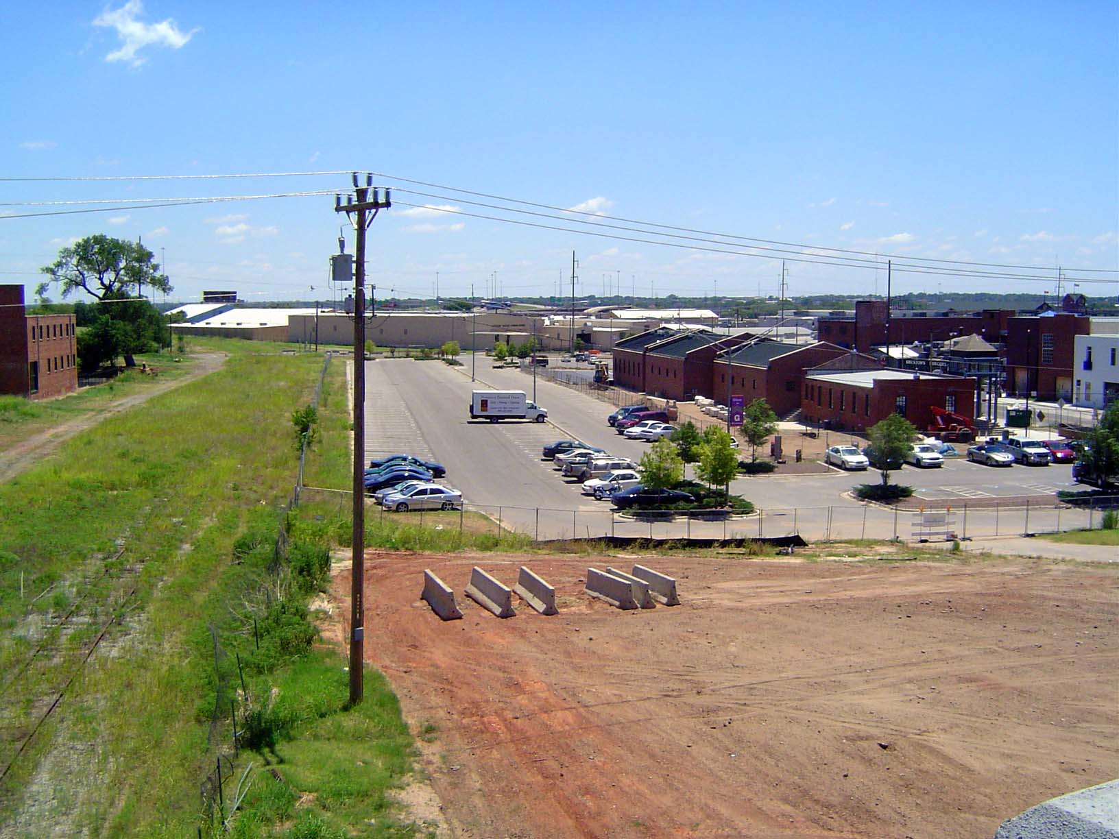
The parking lot in the foreground is on the site of an old railroad yard. A track ran straight through what is now a multi-story parking garage.
Looking the other way. The Rock Island arrived in 1891, and the parking lot in the previous picure used to be that railroad's yard. (The Frisco arrived in 1898, and the MKT or Katy came in 1902. All three converged nearby.)
A railroad map from 1930, showing not only the Santa Fe, in yellow, but the Frisco in red, the Rock Island in green, and the Katy in brown.
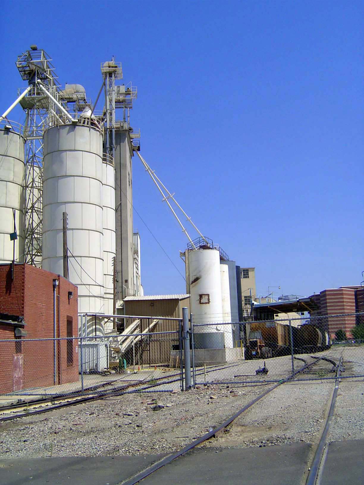
If we jump west, across the site of the former downtown rail yards, we'll find some old Purina elevators. They were built by the Oklahoma City Mill and Elevator Company, which was established in 1899 and for many years produced Choctaw Flour. The mills were acquired by General Mills in 1928 and remained in operation until 1953.
See the track? It's the old Rock Island. What's it doing here?
The Katy didn't cross the city, but the Frisco and Rock Island did; their yards ran smack across the middle of downtown, from the parking lot across to the flour mill.
An old photo of the Frisco passenger depot, on display in the city's Union Station, which was built to sort out the traffic jams created by the trains crossing the city. The building on the right is the Skirvin Hotel, operating today as a Hilton.
And here's the county courthouse. Now that you're completely confused, put the pieces together. The Rock Island and Frisco tracks no longer cross the city, but the flour mill and the parking lot point to their original location. The lines were removed after a campaign lasting literally 20 years and pushed by The Oklahoman since 1909. The railroads weren't bothered in the least by the traffic jams they created, so they resisted change. Then, in 1930, when both railroads were bankrupt, an Oklahoma oilman named Frank Buttram met with a friend, Frederick Eckert, who happened to be chairman of the Metropolitan Life Insurance Company, which held a lot of the railroads' bonds. Eckert heard Buttram's plea and told the railroads to accede to the city's long-pending request to vacate. On receipt of $4 million from the city, they did, and on the site the city used federal funds to build a civic center. Capisce?
Now you understand the axis that runs from the courthouse to the city hall.
The west side of the city hall.
Looking farther west, to the city's music hall.
Flanking the civic center is the city's art museum, opened in 2003 as a conversion and expansion of the Centre Theater of 1946.
Just shy of the grain elevators: the county's photogenic jail.
Here are the relocated Rock Island tracks as they cross from a yard on the south side of the river on their way to the Union Station, built for the Rock Island, Frisco, and Katy after the track relocation.
All three railroads are gone, but some of their tracks have been taken over, partly by the Union Pacific and partly by shortline specials. We'll take a look at one of them, the Stillwater Central, which owns the old Frisco line.
Here's the relocated former Rock Island yard, just south of the river.
The locos read Kansas and Oklahoma—odd name for a railroad that operates from Wichita west to the Colorado Line. It's owner, WATCO, also operates the Stillwater Central.
An ex-Canadian National loco, relabelled WAMX, for Webb Asset Management. How's that for romance?
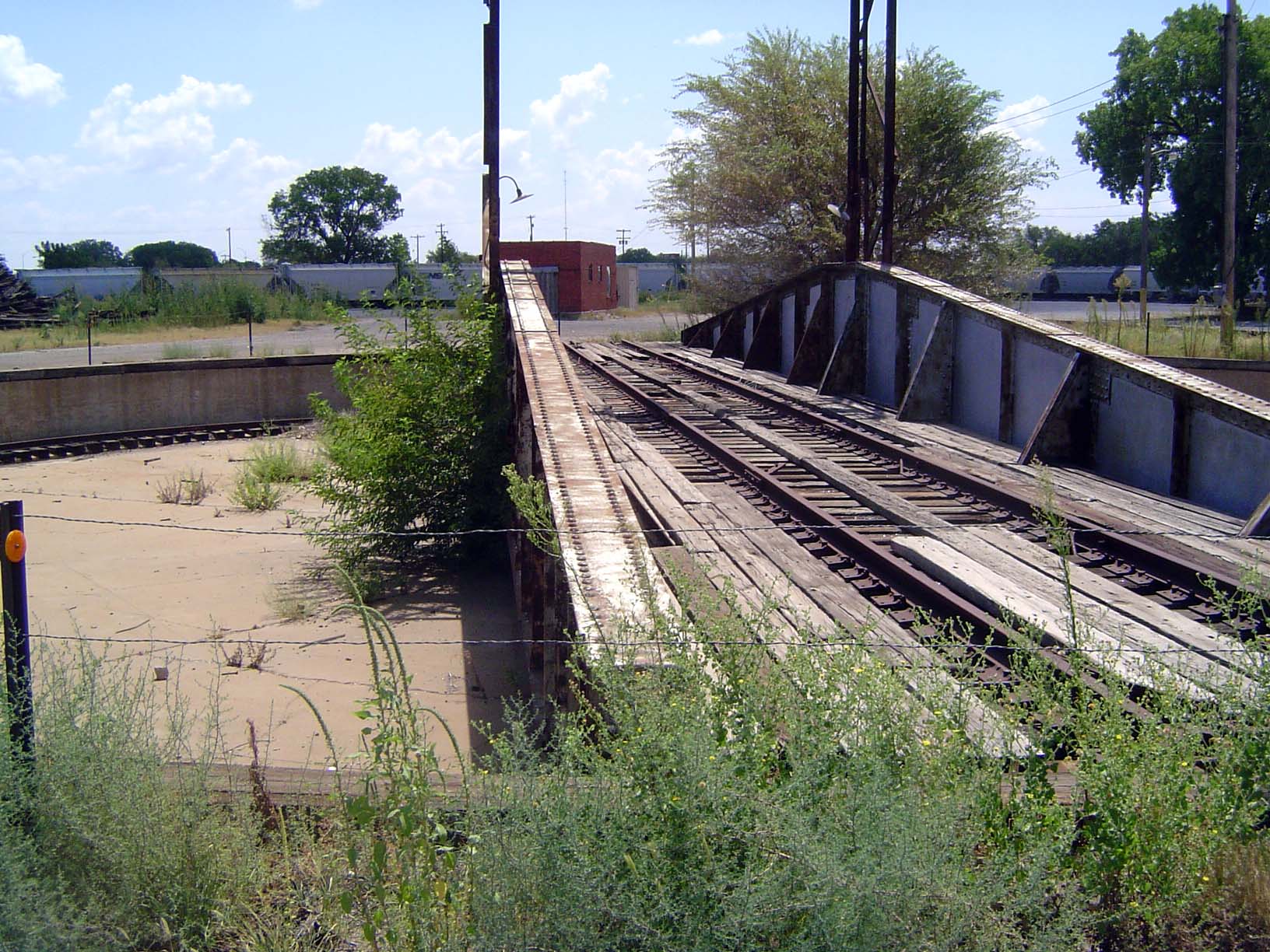
Not many turntables are left in Oklahoma, but here's one. The roundhouse, if it existed, is gone.
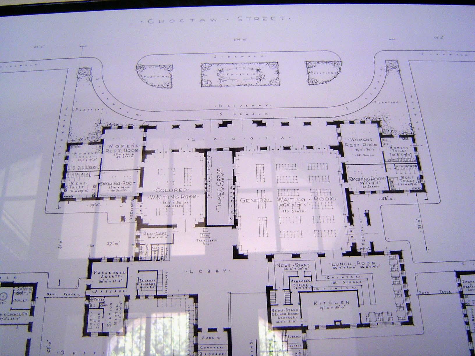
And here's the Union Station, on South 7th Street.
As the plan shows, the waiting rooms were segregated.
Opening day: July 15, 1931
The ticket office was segregated, too. This side faced the general waiting room.
Passengers went to the trains through this subway, which passed under five tracks.
Stairs brought the passengers up to the covered platforms. In 1925, a few years before the construction of this terminal, Oklahoma City had 20 passenger trains arriving and another 20 passenger trains departing daily. They included eight Santa Fe trains running north to Chicago or south to Houston, as well as eight Rock Island trains. Both the Frisco and MKT ran two trains daily to Kansas City.
A streamliner.
From 1927 to 1959, the Rock Island's Texas Rocket ran from Kansas City to Houston. Rock Island trains also crossed Oklahoma City en route from Memphis west to Tucumcari, New Mexico, where they joined the Southern Pacific's line to California.
The platforms survived, sort of, until 2011.
There were no passenger trains by then, and the empty yard was an irresistable lure for highway engineers worried about Interstate 40 which a few blocks to the north crossed the city. Light-rail advocates were horrified but fought in vain against the highway's relocation here.
Sign on a bridge.
Here's the context. When the tracks were relocated here from downtown, the city made sure to avoid grade crossings. In this case, Robinson Street or U.S. 77 ducks under the tracks.
It's worth mentioning in connection with the city's rail service that for several decades interurban trains reached out to the suburbs, in this case 30 miles west to Yukon. The line, which continued to El Reno, opened in 1911.
Here's the interurban to Norman, 20 miles to the south; the last one ran in 1954.
The interurban station in Oklahoma City is gone, but it was on the same block as the city's Union Bus Station, at Sheridan and Walker. The station looks about the same as it did when it opened in 1941, but bus traffic is way down, from 80 arrivals daily in the 1940s to about 26 in 2012, when the terminal was sold for $2 million to a developer who now owned most of the block. He promised to preserve the station's Deco facade. Greyhound was in the process of developing a new terminal a mile to the east, at the corner of Reno and Eastern Avenues.
Behind the bus station.
Here's the front of that red brick building, the Riley and Denford Building, which once had a hotel upstairs and a cigar factory downstairs. Those were the days when a guy could get lung cancer in peace and quiet.
And now we come to highways. Meet Stanley Draper, blueprint in hand. Call him Oklahoma City's Robert Moses.
A memorial to him from 1966. It was placed next to the elevated Interstate 40 as it crossed just south of downtown.
The statue has been moved, though as of 2012 the monument survives.
And here's the road as it was in its last days, circa 2011.
Quiet, isn't it? That's because this picture was taken early in 2012, when traffic had been shifted south several blocks to the new I-40 alignment, running over the tracks behind Union Station. For 40 years this elevated structure had rumbled and shaken with traffic: designed for 76,000 vehicles daily, it was carrying 120,000.
It was in notoriously poor shape.
Here, along with crumbling concrete, some reinforcing has been placed under a crossbeam.
The landscaping on a corkscrew freeway entrance was still being maintained.
Not so the highway itself.
We can walk up that corkscrew. Just keep an eye out; we shouldn't be here.
Decking removal in progress.
Steel and columns survive for a moment.
Pretty soon, just the piers.
A bit like Luxor, no? In the background is the city's tallest skyscraper, the new Devon building.
Soon the columns bite the dust. A new street-level boulevard is to replace the old highway.
And here's the new highway, designed to carry 170,000 vehicles daily. Of all the tracks that used to be here, only one survives, on the far right, and if ever light rail returns to Oklahoma City it will have to squeeze in here or get creative. Cost for the four miles of the new alignment: $680 million.
Over 90 percent of the traffic roaring through won't stop, but the city has gone ahead anyway and erected what it hopes will be an iconic sculpture, lit at night in varying colors.
It's called the Skydance Bridge, and the lead designer was Hans Butzer. The sculpture is part of a new downtown park still to be built. Mayor Cornett: "This soaring monument will welcome visitors and become an impressive landmark for our City."
Many blocks between the old and new highways stand vacant, awaiting redevelopment.
A little creepy? Or merely bucolic?
Maybe money will cure all that ails. Here's some at work: the Devon tower, seen from the elevated (now demolished) expressway.
And this? It's less than a mile to the east and is part of the very large Centennial Land Run Monument.
The horses are shying at the Bricktown Canal, which dead ends a stone's throw to the right and just before the new freeway.
The sculptor was Paul Moore, who apparently had a sense of humor.
No Sooners in sight; everything's legit in this retelling of the story of 1889.
Pity: unless they're up high in a semi, motorists whizzing by can barely see the monument, thanks to artfully placed concrete walls.