By 1910, Oklahoma City had established the pattern that has stayed with it ever since: growth was concentrated mainly to the north. The other directions wouldn't exactly atrophy, but they would grow much more slowly and would develop major zones of decay. Here we look at the inner part of the north side, which developed by about 1920. Like many comparable parts of other cities, it's a mosaic of very wealthy residential neighborhoods floating in a sea of empty lots and rundown neighborhoods. Like many comparable parts of other cities, however, it's also a place of serious investment aimed at people fed up with suburbia.
Let's begin with one of two maps that suggest this north/south imbalance. (Very scarce, the maps come from The Standard Atlas of Oklahoma County, published in 1907 by George Ogle and Company.) South of the river, only sections 9 and 10 are shown almost entirely shaded, indicating that they have been subdivided into streets and lots. Most of the map shows land still held in homestead quarters.
Here's the much more developed north side. Remember that the city began in Section 33, in the middle of the bottom of the township. By 1907, shown here, the city had expanded north—can we use the word "sprawled" yet?—to fill most of Sections 28 and Section 29, plus many other quarters. A decade later, the state capital would be built at the center of Section 27, shown here as still held by homesteaders. (In 1907 this was still Oklahoma Territory, capital Guthrie, 30 miles north.)
The pictures that follow come almost entirely from sections 28 and 29, bordered on the south by 10th Street and on the north by 23rd. You should know that the city's geographical expansion was more than matched by population growth. The 1890s had been slow: the city's population actually fell by 25 percent during that decade. The population in the decade after 1900, however, rose over 600%, from 10,000 in 1900 to 64,000 in 1910. It was a great decade for real-estate developers.
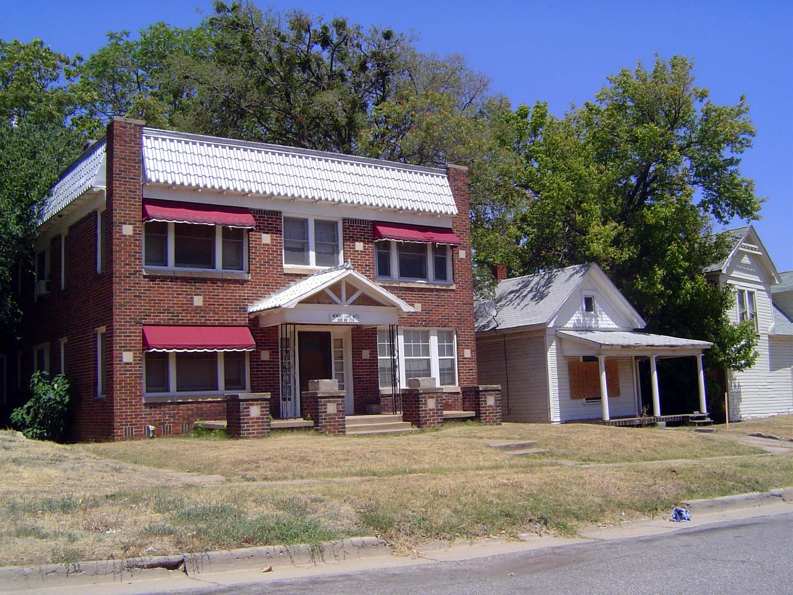
Here's Emerson School, at the corner of Walker and NW 7th, almost smack in the middle of Section 33 but just west of the original townsite. The school opened in January, 1895, six years after the land run and 12 before statehood. It's in what is now a very patchy neighborhood, and it functions as an alternative school, offering grades 6 to 12. It would be interesting to know how much more widely known within this neighborhood the name Emerson was in 1895 than it is today.
There are many empty lots around Emerson School, but there are also some houses that suggest the early character of the city. Here's 627 NW 7th, a block west of the school. The house was built in 1910 and has a bit over 2000 square feet. The house was last sold in 1999 for $22,500.
Just north of the school's front door, these are the Memory Lane Apartments, at 509 NW 7th. They were built in 1900 and have been in the same ownership for a long time. The neighboring shotgun was sold by the Memory Lane owner in 2000 for $75,000. Its buyer bundled the house with two other buildings (one appears at the far right) and sold them in 2006 for $529,000 to Midtown Investments, one of several companies working to renovate the district.
Here's 141 NE 26th, in the southwest quarter of Section 22, 12 North, 3 West. It was built in 1911 and sits on a nearly square lot measuring about 250 feet wide and deep. We're only three blocks from the state capitol.
Across the street, this home at 201 NE 26th is no longer owner-occupied but is owned instead by Home Equities, a set of partnerships with about 200 properties in Oklahoma County.
At the end of the same block: two owner-occupied homes built—surely by the same hand—in 1932. We're at 316 and 320 NE 26th, and if we had X-ray vision we could see the state capitol, just a couple of blocks to the southeast. How many state capitols are so close to such low-value properties?
We've moved south of the river, to the pleasantly shady 401 SE 23. The house was built in 1910 and last sold in 1990, for $6,500.
Another substantial early house south of the river. At 228 SW 22nd, it was built in 1911, last sold in 2005 for $10,500, and is presently unoccupied.
This is 2317 S. Byers, close to the previous two southside houses. It was built in 1910 and is now another Home Equities property. In the back yard is one of the very few derricks surviving in the city. The Oklahoma City Field blew in during 1928. Most of the derricks are gone and most of the wells abandoned, but this dinosaur remains active, managed by the local and tenacious White Operating Company.
With the exception of that derrick, all the preceding pictures suggest a quiet prairie town. We'll watch it change now. Best place to start is a plat showing the north part of the original city, plus some early additions on the north. Notice the large lots at the northwest corner. That's a trend, folks.
The original entries in Section 33 included the Oklahoma City townsite (top coin) and patents to John Brusha for the northwest quarter and Robert Higgins for the southwest quarter. The register shows the United States as grantor and the homesteaders as grantee.
We've moved to the immediate north of the last map. This puts us in the SE quarter of Section 28, land patented to Elias Bourn. You see how the large lots continue, especially with the McClure and then Classen's Highland Park additions. Classen—that would be Anton Classen—was the most important developer of the decade. In 1889, he had come from Illinois to practice law. A few years later he became Register in Oklahoma Territory for the federal government's General Land Office. It was an ideal springboard to launch a career in real estate. One of his early investments was this block—25 acres when you subtract Colcord Heights from the southwest corner. Classen bought it from homesteader Elias for $2,500. Before we look at it more closely, just cast an eye on that circular street at the bottom.
Here is one of the pie-shaped lots it created. The idea was to create an important street lined with churches. You see one of them—the former First Christian Church—in the background. There used to be other churches here, but they're gone, replaced mostly by floral wholesaling. This tiny slice defies economic use.
The former First Christian Scientist Church, abandoned since about 2000.
We're back to the big lots. Here's the subdivider's original plat for the McClure Addition.
And here's the plat for Classen's Highland Park Addition. The lots are not as spacious as McClure's but they are still very large, and they would soon be occupied by the new city's wealthiest residents.
Here's a home built by one of Classen's customers. Now a museum operated by the Oklahoma Historical Society, it's the Overholser Mansion, at 405 NW 15th. Henry Overholser, an '89er who made good, bought three lots in the Classen Park Addition in 1902 and finished his house in 1904. Photographs of the time show it standing in bleak and windy isolation. Still, the location made obvious sense, because 15th street is the watershed. Rain falling here either flows south directly toward the North Canadian, or north toward Deep Creek, which today flows all the way to Lake Eufaula before giving up and joining the Canadian.
Here's the house Judge Robert Hefner built in 1917 at 201 NW 14th. It, too, is now a museum, in this case operated by the Oklahoma Heritage Association, which is headquartered in the building.
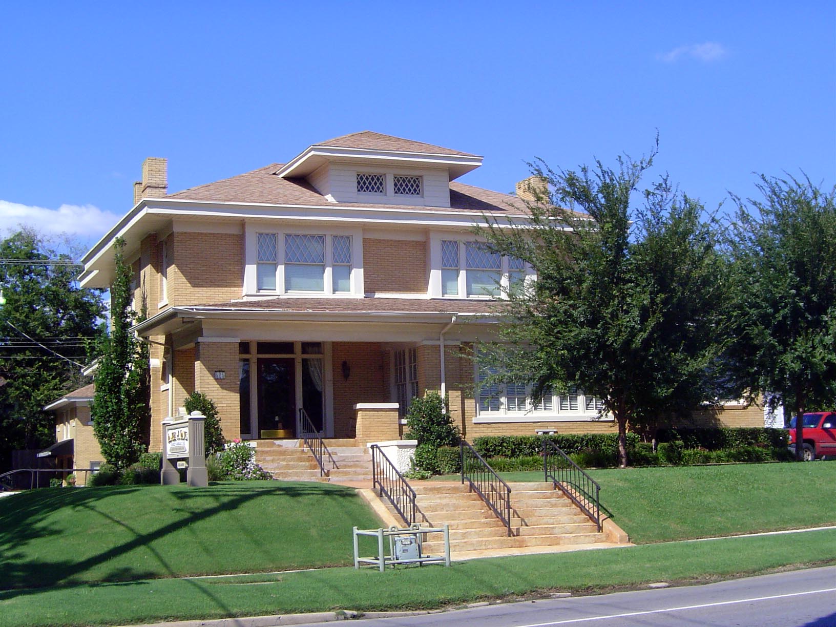
At 20,000 square feet, this house at 1521 Hudson is the biggest and perhaps the grandest of Oklahoma City's early mansions. It was built in 1916 for W.T. Hales, who had come to the young city, run a stable, then turned to horse trading, from which he graduated to real estate. Hales lived here until his death in 1939, when Phillips Oil bought the house and gave it to the Catholic Church as a bishop's residence. In 1984, it returned to private ownership, where it remains. Last sold in 1992 for $400,000, the county assessor reports its market value at about $2 million.
Two blocks away and a copy of a home in Philadelphia, this immense house at 1415 Hudson was built in 1905 for E. H. Cooke. Cooke was a banker and in 1919 created the First National Bank from a failed predecessor. He sold this house that same year, with furnishings, for $50,000. The buyer was an attorney, Frank Wilson, and the house is still popularly called the Cooke-Wilson House. In 1964, the Standard Life Insurance company bought it with the intention of knocking it down to create a parking lot for its adjoining offices, which occupied the demolished Colcord Mansion on 13th Street. Neighbors protested and the company instead converted the home to apartments. The house was later restored to single-family occupancy, but ownership has bounced around with sales in 1993, 1999, 2002, 2002 again, and 2005. The sale in 1993 was for $455,000; in 2005, for $950,000.
Here's 16th Street, two blocks to the north but thematically linked to the Cooke-Wilson House. How? Well, the street runs right down the middle of Section 28 and between adjoining additions, which probably explains its exceptional width. In 1968, the same year that the Cooke-Wilson House was threatened by demolition, the state highway department announced its intention to widen 16th and make it an arterial to reduce traffic on 10th and 23rd. (Highway departments love nature so much that they like to put roads smack in the middle of it.) Local residents went on the warpath and created a neighborhood group to protect what they took to calling—and what is still called—Heritage Hills. The same group, helped by an unusually sympathetic mayor, pushed for and secured the creation of an Oklahoma City Heritage Preservation Commission.
We've stepped just south of 13th Street for a reminder of how detached Heritage Hills is from downtown.
Here's the same view southeasterly from 11th Street. The general principle seems to be that district makeovers take time and involve intermediate periods of desolation.
Here's part of the north side of 13th, right on the fracture between intact and demolished neighborhoods. It's 515 NW 13th, built in 1910 and now law offices.
Its surviving neighbor at 525 NW 13th was built in 1905, sold in 2002 for $125,000, and again the next year for $172,000.
Having sold the Highland Park Addition, shown here in green in the NW quarter of the SE quarter, Anton Classen looked to the northwest and conceived a University Addition, shown here in pink. There was no university, but Classen induced the Methodist authorities to build their planned Epworth University on land he would donate just to the west. That quarter section had been homesteaded by Fred Dewey, and in 1901 Dewey sold Classen a half interest in it for $4,500; the two jointly sold the entire tract to Classen's University Development Company in 1902 for $10,000. Negotiations with the Methodists followed, and Classen sweetened his deal by offering not only 50 acres but $100,000, to be raised by the sale of some of his lots.
Hard bargaining? Maybe, but Classen had blocked up 480 acres and could afford to be generous. He even agreed to build a 100-foot boulevard to the university from the corner of 10th and Walker. You see part of it here, in that diagonal street crossing the southwest quarter. That same street is now called (surprise!) Classen Boulevard.
The smartest thing Classen did, however, was understand that the success of the University Addition would depend on making this edge of the city accessible to downtown. Solution: streetcars, shown here in a snaky black line running through Classen's University Addition and Classen's West Highland Park, shown here in yellow. Classen also laid out the Marquette Addition, shown here in green in the lower left. Its triangular core accommodated the new boulevard and would in time support office buildings and shops, including the city's first shopping center. The small blank area through which Classen Boulevard runs would become the Harndale Addition, another upscale undertaking. Alice Harn had bought this tract from homesteader John Reed. We'll see more of it.
So now we're on 10th, looking west to Presbyterian Hospital, but the street has the nerve to bend. Why? Answer: to accommodate streetcars, of course. They bit the dust about 1946.
We've come around the corner. Walker is on our right and heading north, while Classen Boulevard heads northwesterly. The streetcars might have followed the boulevard but they didn't. Instead, they went due north on Walker, presumably because Classen wanted them running as close as possible to his For Sale signs. The Plaza Court, by the way, is at the southeast corner of the Marquette Addition. John Thomas, founder of the locally famous Crescent Market, built the Plaza Court in 1927. It was the city's first shopping center, and the Crescent Market flourished here with a fleet of trucks making home deliveries. The market moved to Nichols Hills in 1963, and Plaza Court went into a long decline, from which it's only now emerging as part of the Banta Companies Midtown Renaissance. The developer owns about 30 midtown buildings. The Crescent Market itself failed in 2011, shortly after Oklahoma City's first Whole Foods opened a few blocks away.
This is probably the only place in the city where the streetcar system is remembered: the triangle is the former University Station, where students from Epworth University could catch a streetcar going downtown. Yes, this is Classen Boulevard, above 17th.
For rail fans: here's the streetcar fleet, parked in front of the old car barn, which survives in the southwest of the city, across the river at Exchange Avenue.
What's left at the site.
Close-up of the old barns.
The northern terminus of the system eventually was at 50th Street, where the streetcar company operated the Belle Isle Amusement Park. There was also a small lake here, formed by damming Deep Creek. It was used primarily for cooling the company's power plant. It's all gone, though remembered in the name of the shopping center, Belle Isle Station, that occupies the site.
Epworth University failed in 1911, though it was reconstituted a decade later as Oklahoma City University, which moved to a new site, just north of 23rd. The old site remained, however: you can see it here in the larger lots of University Place, which covers the land that Classen had donated for the college. It's surrounded by the western part of the University Addition.
Here's the whole section, showing not only the college grounds but the streetcar track. The University Station, shown a few pictures ago, is the triangle at the lower right corner of the college square.
The University Place plat, showing the college grounds, now abandoned by the failed college, divided into residential blocks and the grounds for what became (surprise!) Classen High School.
Many of the residential lots on the abandoned college's land became apartments: here, NW 17th at McKinley.
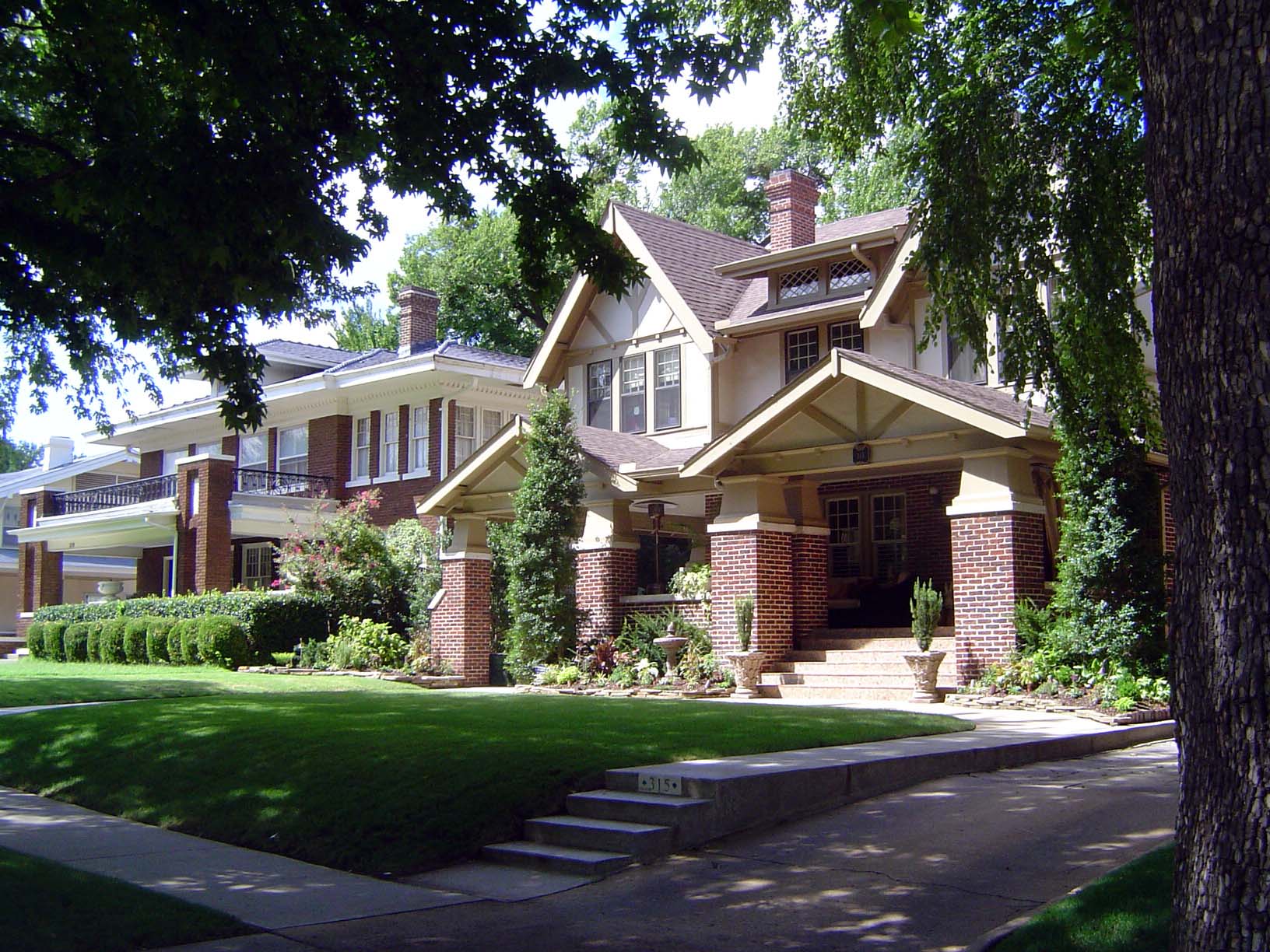
Some became substantial private homes, like this group, centered on a house built in 1924 at 1217 NW 19th.
These houses are across the street from the south side of the college grounds. The house on the left, built in 1910 at 1316 NW 17th, was sold most recently for $44,000 in 1999. The building on the right, in apartments, sold in 1996 for a mere $13,000.
Something entirely different: the unusual and steel-framed Opal Staley house, built in 1940 at 1301 NW 20th.
Time to retreat from the area of Epworth College and go back to the area where Classen really cleaned up. See that pie-slice block? It's accommodating the streetcar track coming north on Shartel and curving into 18th.
Same place, here looking east on 18th Street, where the track curved south to Shartel. This is an area generally of big single-family homes, big because the streetcars provided fine access to downtown. At this corner, however, where the streetcars presumably stopped in the triangle, two three-story apartment buildings were built in 1915 at 732 W. 18th and 1814 N. Shartel. You see them straight ahead here.
The name Shartel, by the way, recalls Classen's partner in the streetcar business, John Shartel. He had grown up on a Kansas homestead and become a lawyer working for a predecessor to the Rock Island railroad. He joined Classen in 1902, and a year later they were running electrified cars. The tracks reached Belle Isle in 1910, but the system kept growing with interurban trains that reached west to El Reno in 1911, south to Norman in 1913, and north to Guthrie in 1916. By 1924, Classen and Shartel ran 65 miles of city and 80 miles of interurban track.
Proximity to the streetcar was a plus in the days before cars. Here, from 1914, is the house at 804 Shartel.
Here, from 1910, is the house at 801 NW 17th. It last sold in 1994 for $110,000.
Here's 801 NW 16th, built in 1907 and in the same family since at least 1976. All three of these houses were within a minute's walk of the tracks.
Remember the odd triangles of the Marquette Addition? Here they are again, in the northwest quarter of the southeast quarter of the map. In the upper left is Harndale. It was the blank area on the last map we saw of the area, but now you can see that it straddles Classen Boulevard with a distinctive, dumbbell-shaped park. Do you think it's in good shape today, or wrecked?
Here's the park today: very well-kept.
And here is a house midway between Harndale and Classen's Highland Park Addition: it's 700 NW 16th, in the West Highland Park Addition. You can see how Classen was filling in the gap between mansions to the east and streetcar tracks to the west. This house, by the way, has 4,700 square feet. It was built in 1909 and sold in 1982, '87, '89, '94, '96, and 2005—that last time for $625,000.
Another house in the gap: 600 NW 15th, built in 1907 and in the same family since at least 1978.
Dr. J.C. Nichols, a major name in later decades, got involved with land just east of Classen's Highland Parked Addition. This was Winan's Highland Terrace, named for the homesteader. Notice the park at the northeast corner of the tract? We'll come back to it.
For the moment, here are some early Nichols' houses along the 300 block of NW 19th. We're going to look around for a minute.
Across the street. The house on the left sold in 2005 for $395,000.
A few houses down. Do you see what these buildings—all built by Nichols just before 1920—have in common? Answer: they have nearly identical floor plans, despite different facades. This was one way Nichols got efficiencies of scale. He had his own building crews, too.
And here's Winan's Park.
The interesting thing about it is that it forms a barrier between nice homes to the west and an industrial neighborhood to the east. That's where the Santa Fe railroad ran, after all, and it formed a wall separating affluence from relative poverty.
Remember this, where the Plaza Courts were built at the very southeast corner? Maybe it can set us off on a sequence of pictures showing other things happening in midtown.
For example: here's the old building of Tom Braniff's Mid-Continent Life Insurance Company. It was built in 1926 at the southeast corner of the Harndale Addition. When Mid-Continent failed, the building was sold in 2000 to American Fidelity, which sold it in 2001 to the Oklahoma Heritage Association. Plans are to remodel the building into the Edward Gaylord and Boone Pickens Oklahoma Heritage Center. It's the usual story: they came up with the $3 million to buy the place, and so they get their name on it.
Midtown also became an attractive site for apartment buildings and hotels, especially along its main streets. Here's one of the earliest: the Marion Flats, built at the corner of 10th and Broadway in 1907. Long derelict, it's being renovated by Banta.
Another apartment building: the Aberdeen, at 125 NW 15th, just a block east of Heritage Hills mansions.
A third: the 1920 Wesley Village, now going into lofts. Ssh! Advertising genius at work.
Closed while waiting for an investor: the 1928 Sieber Hotel at 1311 N. Hudson.
The Palo Duro Apartments, built in 1929 at 409 NW 11th, were last sold for $79,000 in 1997.
Amazing, how the right font can make such a difference.
The earliest of them all? Maybe. In 1901, this was the Haddon Hall Family Hotel, at 215 West 10th. In 2006, it was part of a 50-parcel-plus package that went for $5.2 million. More midtown makeover. A historic note: the most famous writer to grow up in Oklahoma City was surely Ralph Ellison. Almost all the buildings associated with his childhood have been demolished, but here's an exception: his mother worked here as a chambermaid after her husband died in 1916. That was the year, by the way, when the city passed a law—quickly struck down as unconstitutional—making it illegal for anyone to move into a block that was three-quarters or more occupied by people of another race.
And here's maybe the only other building linked to Ellison. It's the old Greenlease-Moore Cadillac agency on Broadway. Opened in 1920, it was designed by Solomon Layton, the city's most prominent architect. Lawrence Jackson, in *Ralph Ellison: Emergence of Genius *(2002), tells the following grim story (pp. 79-80): "Near the beginning of the summer, he [Ellison in 1931] ran into a classmate who told him about a job on Broadway, if he could hustle over there. By the time Ralph made it up to Greenlease-Moore Used Cars on 1016 Broadway, between Ninth and Tenth, he was sweating freely. The white lot manager invited him to sit down on a crate and rest, while the sun hovered overhead, pushing the mercury past 100 degrees. Thankful for the rest, Ralph responded freely to questions about his family. The friendly interview continued until he felt sure that the salesman was about to make a job offer. Seconds later, he felt a strong surge of electricity in his tail. He shot upward, electric current spurring him off the crate, and landed in the dust, the laughter of the salesman ringing in his ears. Holding himself as he walked away, Ralph realized that the entire interview had been a set-up."
In the next group of pictures we'll look at what little else is left of Ellison's childhood neighborhood, but since we're on Broadway and in the middle of the remarkable lineup there of car dealerships from the 1920s, we'll look around. Here's the view south on Broadway.
The oldest agency was Buick, which occupied this site from 1911 to 1926. It adjoins the Oklahoman's office.
Across the street, at 601 N. Broadway: this was the McDaniel agency from 1920 to 1922 but the Broadway Service Station from then through the 1940s. Now lofts.
The Carhart agency sold cars here into the 1920s, but the building became a C.R. Anthony store in 1948. By the '80s, Anthony, headquartered in Oklahoma City, had 300 stores. In 1997, the chain became part of Stage, a Houston-based retailer.
On the left was a Packard and Stutz dealer in 1920; in the middle was Norris Olds in 1917 but a Chevy dealership in the 1940s; on the right, McClelland-Gentry sold Hudsons in the 1930s.
In 1920 this was Shelburne Dodge, Hupmobile, and REO; later, it was used by a tire dealer.
In 1926 Buick opened this building, which was not only a dealership but an assembly plant. The Banta sign, mid-height, indicates another renovation.
Across the street from it, here's Chieftain Motors, a Pontiac dealership from 1927.
The Magnolia Petroleum Building of 1919. A gas station operated in the alcove until 1960. Despite the impressive lineup of car dealers on Broadway, it's doubtful that anyone here in the 1920s realized how profoundly cars would change Oklahoma City in the following decades.