The east side of Oklahoma City—that would be the side east of the Santa Fe tracks—is comprised of five neighborhoods. First, to the north, there's the capitol; second, to its southeast, there's the University of Oklahoma Health Sciences Center, a complex of hospitals and research organizations; third, there's a well-to-do residential district between the two. Fourth, farther south, there's an industrial and warehouse district converted in recent decades to an entertainment district, and fifth, there's the city's large Black neighborhood, which over the years has moved north and eastward. That Black neighborhood has discouraged east side investment for decades, and though the entertainment district is now on its feet, the island between the capitol and medical center is just that—an island of comparative prosperity in a sea of more modest and often deteriorated houses. In addition, the hand of urban renewal has been exceptionally heavy south of the Health Sciences Center and has decimated whole (mostly Black) neighborhoods that are only now, slowly, slowly, returning to life.
You can see the Santa Fe track running down the section line between Sections 33 and 34. You can also see the Missouri Kansas and Texas Railroad (the Katy) coming in at 2 o'clock, while the Rock Island is closer to 3. The Rock Island track, which hugs the south slope of a hill in Section 34, separates the old industrial neighborhood to its south from residential neighborhoods to the north. The state capitol, not yet built, would be built in the middle of Section 27, on land donated by two landowners, Harn and Culbertson. They'd be compensated by development on surrounding land they retained.
Here's the southwest quarter of Section 34, where the Rock Island yard cuts across the so-called Military Addition. That name is no mystery: this quarter-section was home to four companies of U.S. infantry troops, plus some cavalry, all literally sidetracked here on April 21, 1889, the day before the land run. By 1894, the troops were gone, and the land had been turned over to the city, surveyed, and sold.
At the bottom of the Military Additioni plat, there's a school block. This became the Frederick Douglass School, Blacks only, and boasted many fine teachers and students, including Ralph Ellison. The kids made their way to the school from the black neighborhood north of the Rock Island tracks. Parents worried, because California Street was an undisguised red-light district.
The Rock Island railroad is gone, and its Oklahoma City freight yard is mostly a parking lot. The freight station survives, sort of: it's becoming a local police station.
Some old factory buildings survive, too, including the Oklahoma Furniture Manufacturing Company, which was built in 1904. The green awnings should raise an eyebrow. What's happening?
Adding to the puzzle, here's the Wells Fargo warehouse, which was built in 1906 directly across from the now-demolished Katy depot. Wells Fargo was here until 1917, when its Overland Express business folded. The building was then used by American Railway Express until 1954. More recently, the building was a general store run for nostalgic shoppers by descendants of Daniel Boone himself. They folded, apparently for lack of parking. That explains the "for lease" sign. Still, the building sold to out-of-state investors in 2006 for what seems the very substantial price of $1.15 million. They must have thought it had promise.
The MKT depot, demolished in 1959.
Looking northwesterly past another old warehouse to the Oklahoma First tower. The sidewalk and paving are surprisingly good, which should suggest what's going on.
Quick detour for a nice detail.
New brick pavers.
Aha! Now you get it. Restoration in pastels spells festive retail. Call it Bricktown, one of the city's most successful urban renewal undertakings. Credit goes to Neal Horton, who began buying buildings here in the 1970s.
The building in the distance, built in 1910 for the Oklahoma Furniture Manufacturing Company, opened in 1988 as a Spaghetti Factory: it was the first Bricktown business to open, but it only used the ground floor: the 216 windows upstairs were bricked up. [The Spaghetti Factory closed in 2016 during that company's travails, and the building itself came within a whisker of being declared legally abandoned; its owner, long disguised, turned out to be Vereit, a real estate investment trust in no hurry to sell the property or do anything with it. That's what happens when nationwide you own over 4,000 properties worth over $15 billion. What's one more?]
[Late in 2017, two local investors (Sam Coury and Danny Wright) bought the building for $3.8 million and set out to convert it to something. Maybe a hotel, maybe apartments, maybe condos. Retail on the ground floor. Time would tell.]
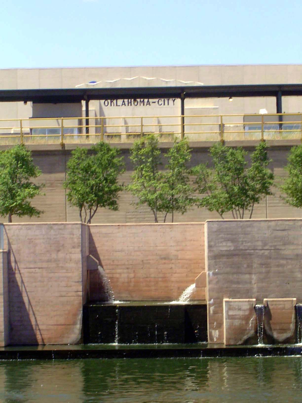
And what is festive retail without water? So an ornamental canal was created in 1999, entirely new and conceived solely as an amenity to attract visitors. Some 10 million came in 2005, drawn by a Bass Pro Shop, a multiplex theater, and 41 (count 'em) restaurants and clubs. The electrical-supply store advertised on the left still exists but not at this location.
Neal Horton didn't see any of it: he had died in 1993 at age 55.
(The authority on Bricktown is Steve Lackmeyer, who's written the book on the subject and who also is the real-estate reporter for The Oklahoman.)
Here's the start of the canal, with the Convention Center in the background, behind the Amtrak (old timers will call it the Santa Fe) depot.
A closer view, with a handsome old sign on the railroad passenger platform.
Room to grow, too.
Coming soon: condos on the site of the Katy depot.
The Bricktown ballpark opened in 1998.
So much for the south half of the Military Addition. It's time to head north. We'll look first at the Maywood Addition, shown here in the yellow of the northwest quarter.
Here's the original plat, dated 1892. The names of the developers, Stiles and Geary, survive in street names. The diagonal is named Harrison, for the sitting president. It may suggest pretensions, but they never came to pass.
We're looking southwesterly along Harrison toward downtown. Behind us is the circular Stiles Park, now reduced to a traffic circle on the approach to the medical center.
We've turned around 180 degrees and are looking at a geometric sculpture in the center of Stiles Park. The medical center covers many blocks to the northeast.
The blocks around the park had been intended as a prime residential neighborhood.
About the only thing left of those hopes is the former Maywood Presbyterian church, built in 1907 but abandoned for at least a decade before it was renovated as private, then state-government, offices.
We've moved just north and east of Maywood, to the original campus of the state medical school.
And here's the quarter-section to the immediate north of the last picture. Together these maps frame the island of mostly White homeowners on the eastside. They also introduce some of the first neighborhoods to abandon the grid layout.
The first building of the University of Oklahoma's medical school is now the College of Public Health and is nearly lost amid the 300 acres of the Health Sciences Center. Here, 12,500 people work in a string of buildings that were built between 1992 and 2005 at a cost of $375 million. That's not counting the nearby PHF Research Park, which collects biotech businesses.
The state capitol was built between 1914 and 1917 in the center of Section 27. The dome is a slightly lighter color than the building because, though always part of the plan, it was only added in 2001.
The north side of the capitol grounds are bisected by 23rd Street, here in the foreground, while the north-south Lincoln Boulevard separates into two strands and embraces the capitol on its east and west sides.
Here's the plat of one of the additions between the medical center and the capitol; it shows a broad boulevard.
Here it is on the ground. It's the second State Capitol Addition, of 1920, with the McMecham Parkway separating the two lanes of the street.
East Street curves uphill from the parkway toward the Lincoln Terrace Addition, laid out by John Culbertson, the developer who gave the land on which the capitol stands.
East Street duplexes and apartments, from the mid-1920s.
The local shopping center was built in 1928 by Doc Nichols, who by then was at work on another commercial development he called the Spanish Village—now the Paseo, which we'll see in the next group of pictures. According to the city directory of 1947, a Safeway operated right here, back in the days when supermarkets weren't so super.
The Lincoln Terrace Apartments, built in 1948.
The addition was surveyed by Warren Moore, who came to Oklahoma City as the engineer for Classen and Shartel's streetcar company but who on his own then surveyed a very high percentage of the city's new additions. He never, or rarely, laid out a grid.
Covenants and declarations. The prohibition against Black ownership or residence was standard for the time.
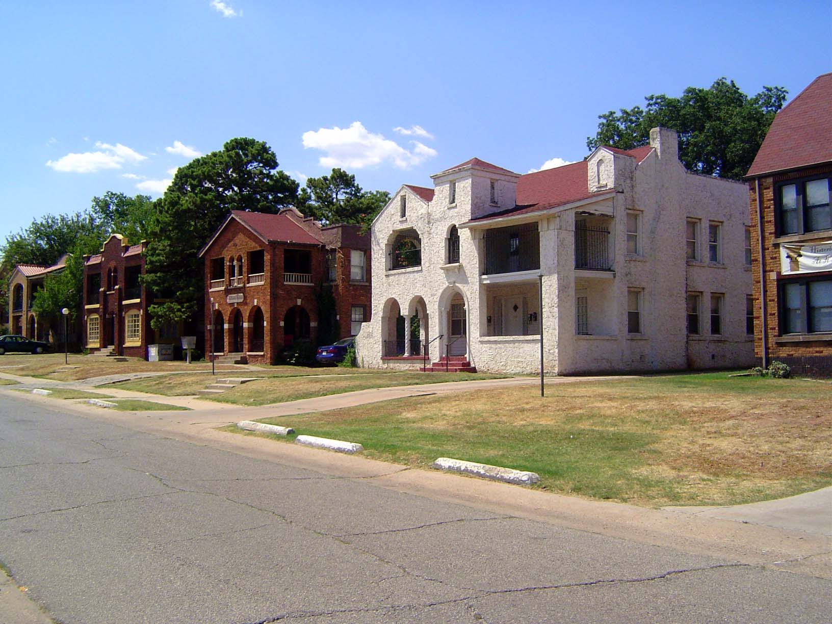
We'll look at a few houses in this addition. Here's something unusual. It's 800 NE 21st, built in 1928.
Another raking gable, also from 1928: 717 NE 20th.
A third house from 1928. At 600 NE 17th, it sold in 2003 for $375,000 and two years later for $470,000.
One of the handsomer Spanish-style homes in the city: the Leo Sanders home at 631 NE 17. Built in 1931, it sold in 1992 for $175,000 and in 2003 for $430,000.
We're leaving the island now and heading south. Here, at 13th and Walnut, are the Walcourt Apartments, built in 1927. On the National Register of Historic Places, the building was abandoned in 1992 and slowly fell apart until, in 2017, a local builder bought the place and set out to renovate it. There's a wood frame under the brick, but the builder, Brent Swift, claims that the building is still sound.
Now we're heading back south, toward the tracks. Here's 700 NE 4th, from 1930.
721 NE 3rd, built in 1910 and sold in 2001 by Power House Church.
A house—no apparent address—in the 300 block of NE 3rd.
Here's 711 2nd, built in 1910 and sold by the city to Harvesters Assembly in 2004.
Urban renewal—specifically the Harrison-Walnut Project—moved into this neighborhood and cleared hundreds of houses judged beyond repair. Many blocks remain empty, though the county records still show private owners for each lot.
First Street, with every house gone since the 1970s.
As if clearance wasn't enough, the city succeeded in getting Interstate 235 to come right through the old Black neighborhood, dividing it into two very poorly connected halves. Here, taken near the previous picture, is the freeway seen from 1st Street.
The view of the same corner—1st and Lindsay—from above.
We've come over to the west side of the freeway and are looking east along 1st street toward the interstate. Ralph Ellison was born in a rooming house that stood somewhere along this empty block. The route of the interstate was designated in 1976, and an oral history includes this masterpiece of understatement from the highway-planner responsible for the routing: "The residents of the minority neighborhoods south of 23rd Street expressed some concern over the project and we tried to answer all their concerns but, in hindsight, perhaps we didn't." Ya think?
Background: in 1961 the city's new Urban Renewal Authority hired the illustrious I.M. Pei. On the basis of his recommendations, the city in 1964 adopted a General Neighborhood Renewal Plan, at first covering 528 acres but expanded the next year to 1,350. The idea was to clear the city's core and create a new office district, a convention center, a cultural center, a retail center, and a major residential area. The plan was adopted in 1965 but divided into stages, the largest of which was the 1,258-acre Kennedy Project, on the east side. Here the city sought to demolish 3,996 homes. Federal money flowed between 1967 and 1973, then stopped when the job was half done.
Now you understand the desolation of the previous pictures. And now you also understand why the replacement homes in the Kennedy Project—in this case on Wisconsin Avenue—were all built in the early 1970s. They all run about 1,300 square feet and are presently worth about $50,000. The neighborhood is as Black as ever.
Another view.
Those homes are all along the cul-de-sacs shown here at the bottom of the map, in the Kennedy Addition.
Think there's a mainline supermarket on the east side? The city is trying to get one. Here, at 23rd and Eastern, is one of the two local supermarkets serving everything east of the Santa Fe tracks. It's the locally owned Hometown Market. The building was built in 1962.
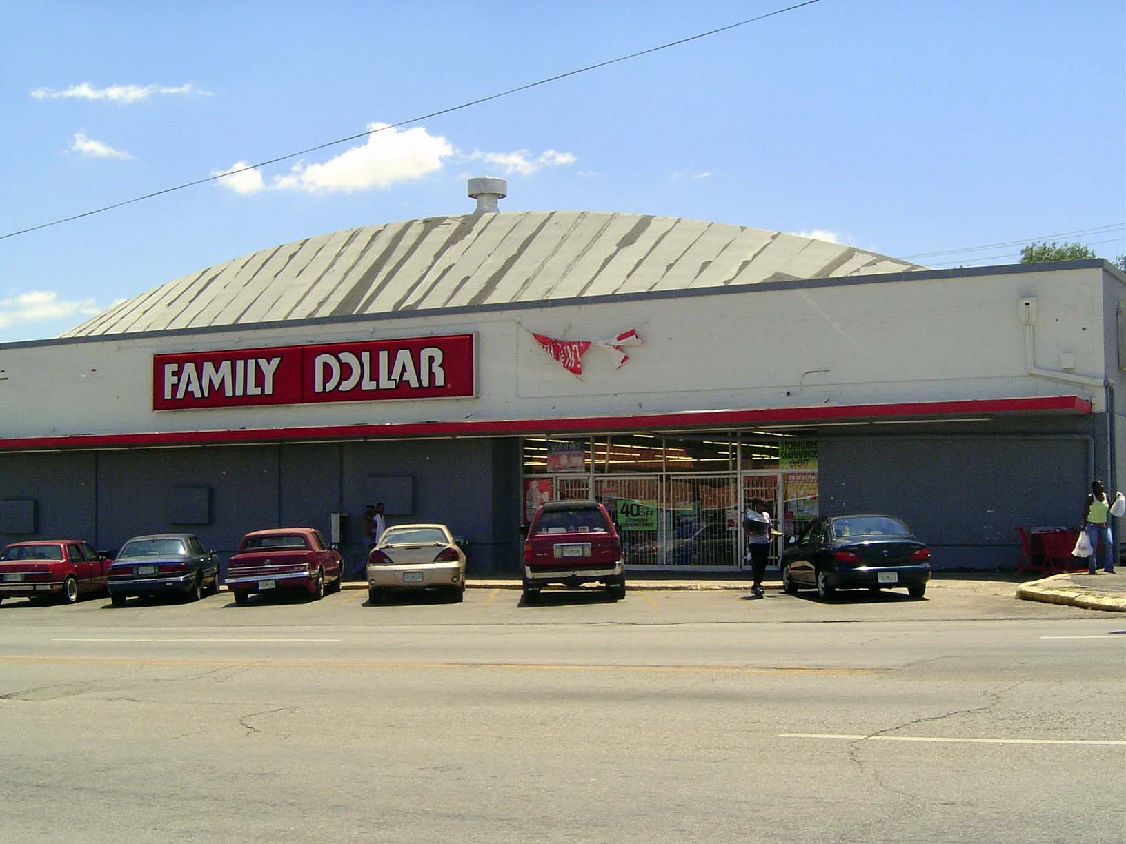
The competition is across the street: it's Family Dollar, in a building from 1950. Notice the accordion gate behind the plate glass.
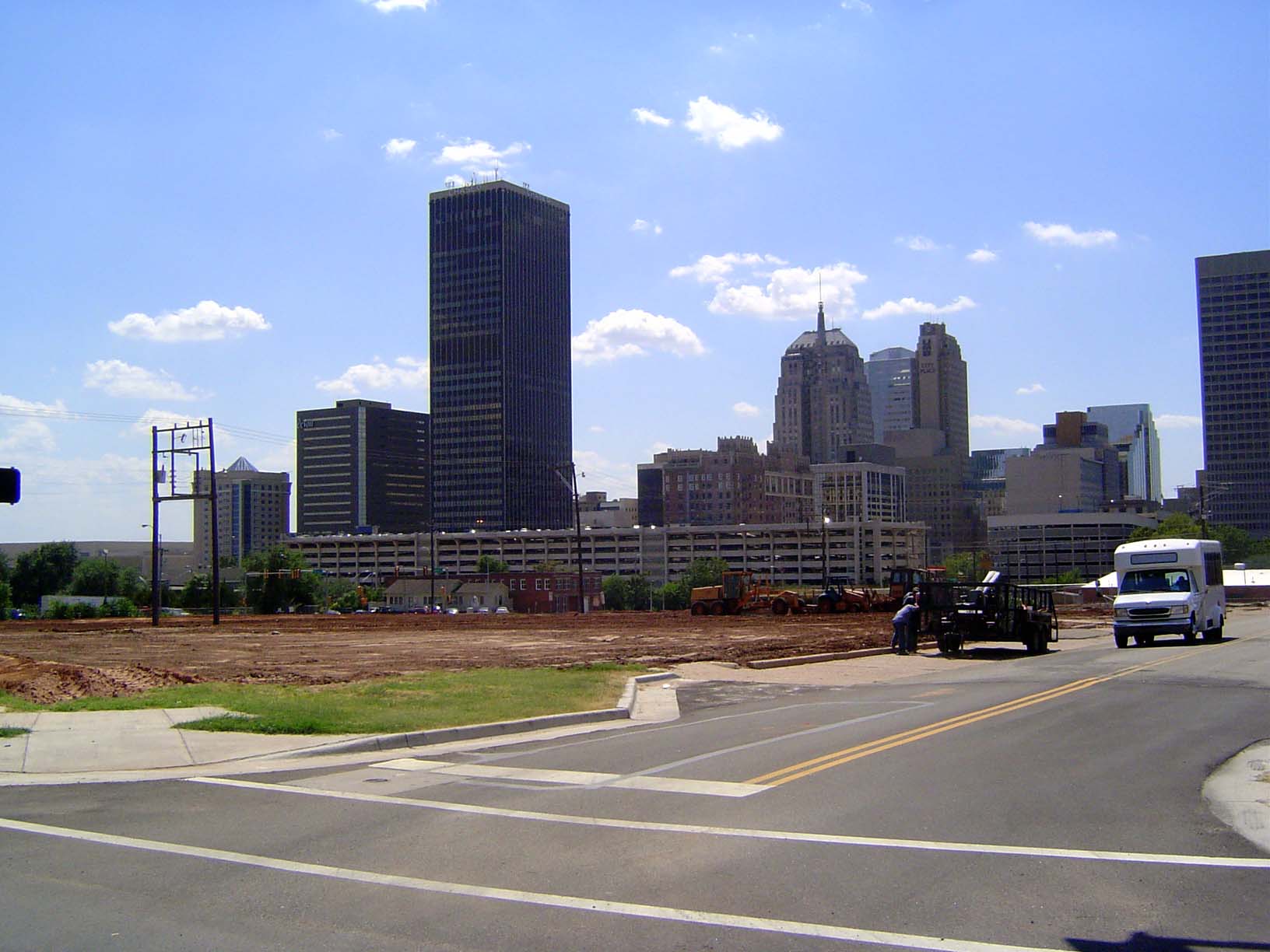
Looking east on 23rd St, with the capital dome in the distance. It's a long way from Heritage Hills, a mile and a half in the distance.
If you're looking for anything hinting at the prosperity that once existed in the old Black neighborhood, you'll wind up here, at 300 NE 3rd. It belonged to Sydney Lyons, who established the East India Toilet Goods Company. In his backyard he concocted cosmetics sold to Blacks around the country. Since 1983 the house has been on the National Register of Historic Places.
The most explicit reminder of the most famous author born in Oklahoma City.
Slowly, private investment is coming into this manmade desert. Here are the Deep Deuce Apartments, 294 apartments built in 2001 and sold for $15,000,000 by the Oklahoma City Urban Renewal Authority to Arbors of Bricktown, a partnership from Memphis, Tennessee. In 2006 the complex was for sale again, this time for $28 million. These two blocks were the heart of Deep Deuce, the cultural center of Oklahoma City's Black community from the 1920s through the '40s. The Aldrich Theater stood on the near side of the corner in this picture, while kitty-corner from it was the Musicians Exchange. One important leftover from that period is Calvary Baptist Church, still visible in the distance here.
Adjoining the apartments is the Deep Deuce Grill, at 307 NE 2nd. The building is from 1938 and was sold by the Renewal Authority to Second Street LLC in 2002.
An entirely new house, built in 2005 just south of the medical center: 614 NE 6th.
Slated for change? In 2003, investors bought this house, built in 1920 at 618 NE 6th, for $10,500.
Another survivor near the medical center: 615 NE 5th, built in 1920 and sold in 1998 for $10,000.
Here's a plan to bring brownstones to Maywood.
This site, once presumably houses, was used as a parking lot by Kerr-McGee after 1972. In 2006 the land was sold to the Triangle Development Company for $1.6 million. The developer's website (reinventokc.com) assures us that "the pinnacle of the elite urban lifestyle is found in The Brownstones at Maywood Park."
Another chunk of land going into condos; part of the western edge of the medical center is in the background.