Home UpOahu 1: A Perimeter Circuit
How long do reputations outlast reality? I'm not thinking about the Yankees or Harvard. The subject here is Hawaii. Through the course of the 20th century, clever marketing (think Matson Lines for starters) created an image of Hula girls and palms. People came. They really came when jet travel dropped the cost in time and money. It's enough to make you wonder how many other paradises will get Honolulued in the coming century.
We can mentally manhandle the quadrangular island into a clockface. Here we are 20 miles west of Waikiki and at an imaginary seven o'clock. This is Barber's Point Lighthouse, rebuilt in 1933 to replace a light built in 1888. No hair salon: just Captain Henry B. The coral shore isn't for barefooters, but the palms and sand seem attractive. A bit like paradise?
Oops! There are a million people on this island, and they want their electricity. This AES Hawaii Power Plant generates about a tenth of it. Who's AES? It's American Energy Services, a Virginia-based contractor selling power to Hawaiian Electric. Nobody knows when AES learned to speak Hawaiian.
No palms here. The plant burns about 660,000 tons of coal annually. Where from? West Virginia? Not a prayer. Try Indonesia.
Want to drive a car? Then don't say nasty things about Hawaii's oil refinery. With an itsy-bitsy output of 54,000 barrels per day, the refinery was a rounding error for Chevron, which sold it to Florida's Rock Rock Capital in 2016.
Barber Point has lots of other good stuff, including tour buses at the end of their line.
Schnitzer Steel Hawaii. What was the landscaper thinking?
Look: beach access! Hope springs eternal.
Ouch, ouch, ouch: you have no idea how sharp coral can be until you try walking on it.
Tricky even with shoes.
We've driven about ten miles up the coast, at a point we'll call 10 or 11 o'clock. We're in the Wai'anae District or, in Hawaiian, the Wai'anae moku. The beach is only marginally better here, though you can see fine sand in the distance. Perhaps the most striking thing is the vegetation struggling on the mountains.
The Wai'anae Range is the southern edge of the former Wai'anae volcano, created about four million years ago but mostly lost to the sea in a huge, prehistoric landslide. The southern rim of the cone survives here. Precipitation on this lee-slope, protected from the Northeast Trades, is low enough that you can just about film a Western. There's a guy with the rifle hiding up on one of the ledges. Stagecoach left.
Plenty of surf, but this isn't the place to try it.
Better. We've come around Ka'ena Point, the northwest corner of the island, to about 11 o'clock. That puts us on the North Shore, where a coastal terrace hugs the north face of the Wai'anae Range. The terrace makes a fine runway for Dillingham Field, which is mostly used by gliders and crazy people with parachutes.
Did your ears perk up at the name Dillingham? Old Benjamin in 1898 opened a railroad from here counterclockwise around the point and back to Honolulu, at about five o'clock. Purpose: mostly to serve the sugarcane plantations established here, but—frosting on the cake—to bring tourists to a hotel he built. It's long gone. So are the tracks. And the sugarcane. Benjamin, too. The beach is awfully nice though, and about as deserted as you're likely to find on the island. Of course, I bitterly regret having pointed this out. Don't you dare!
There's a calming reef out there.
Dillingham established a ranch here in 1897, and his son Walter (1875-1963) built the private Dillingham Lodge in 1917. At his death, his descendants sold the Dillingham Corporation, by then deep into Hawaiian real estate, to private investors for $347 million. The Ranch continues as an equestrian center: you can get married here or have a yoga retreat. No kidding.
Dillingham's railroad served the Wailua Sugar Mill, which was taken over in 1899 by Castle and Cooke. Cane mills generate lots of waste, usually used to power the mill itself, and the stacks tend to last longer than anything else. That's the story here.
Through mergers, Castle and Cooke became part of today's Dole Food, though in 1996 Dole spun Castle and Cooke off as a separate real-estate venture.
The mill closed that year, leaving behind crushing gears that Chaplin could have used, or good old Fritz Lang—who (editorial note) is looking more and more prescient.
Looks original but isn't: this soap factory does not appear on an aerial photo published in Joseph Kennedy's North Shore of O'ahu, 2011.
On the other hand, this does: it's the company town built for the sugar mill. It's still very much inhabited, partly it seems by descendants of the mill workers.
Like lots of postwar suburbs, the homes were all the same when new, but many have been modified over the years. Here's one unchanged.
Another. Lots of crawlspace.
Another.
Here's a renovated one.
Privacy.
We've come a few miles farther east along the north shore to Kaiaka Bay Beach Park. We're close to the site of Dillingham's old hotel, which closed in 1943, not a great year for tourists. The site of the old hotel is now Waialua Joe's Seafood Restaurant. That's still Ka'ena Point, the northwest corner of the island, in the distance.
Here's the hotel, as shown on p. 471 of Our Islands and Their People as Seen with Camera and Pencil, a massive and triumphalist account from 1899. Sad to say, the only comparable accommodation for visitors today is on the island's military bases.
Is the tape really necessary? Think someone's going to come skipping along?
Forget the sharks at Shark's Cove; the coral is brutal enough.
Still, tourists come, and they're always hungry. We're in Haleiwa.
You didn't believe me?
Tourist businesses.
But here's something with roots: a building put up in 1923 by one of the Japanese migrants who came to work on sugar. The building has changed tenants over the years; in 2016 it was Global Creations Interiors, but a few years earlier it was Haleiwa Eats, a Thai restaurant.
Contrary to rumor, McDonald's restaurants don't all look the same.
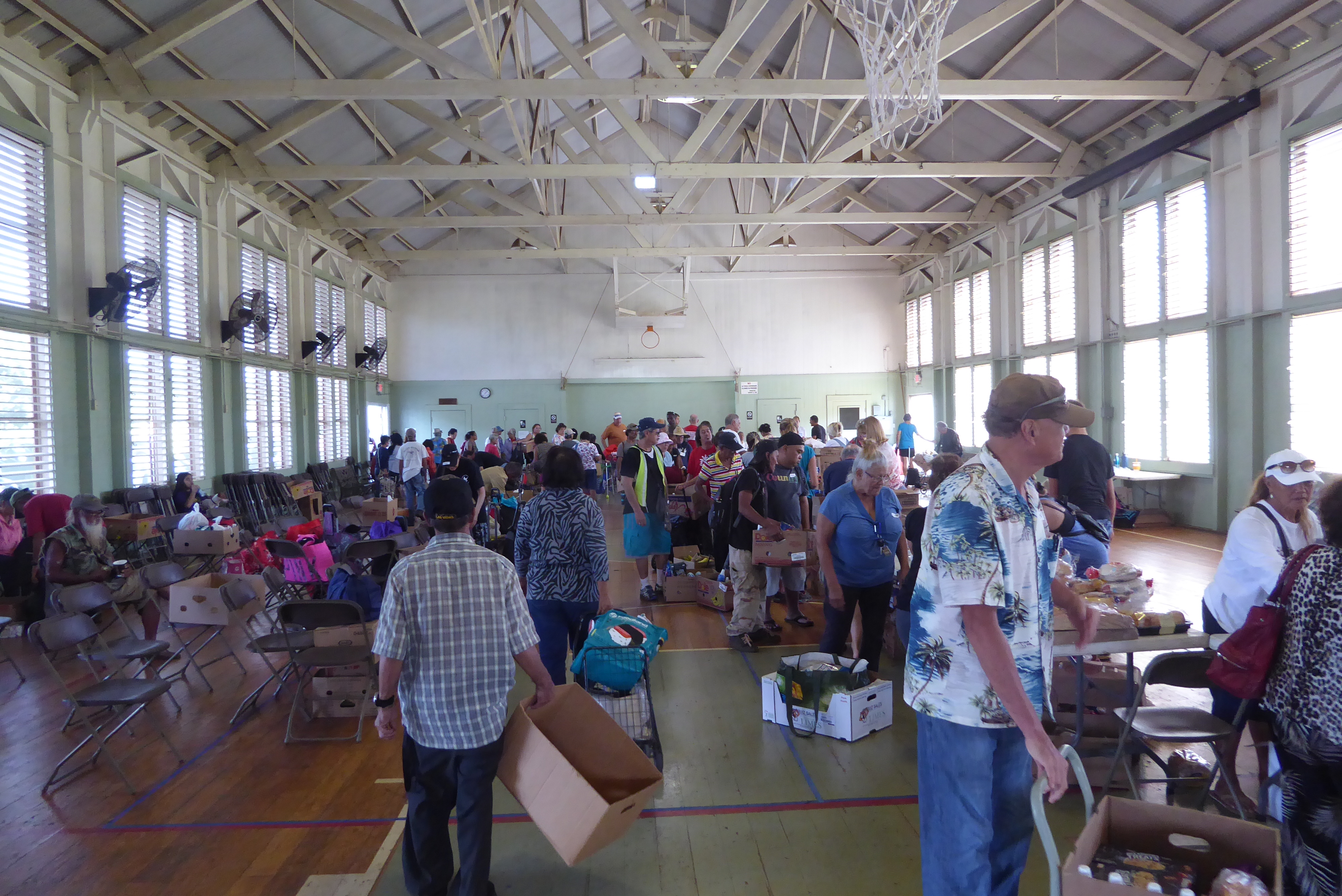
Here's the Waialua Community Association Building, erected as a basketball court. Now?
On this day it was the North Shore Food Bank.
But there you have it: Oahu as not quite paradise. And not a hulu dancer in sight.
The north shore faces the trade winds, which bring enough rain for trees to grow. This is the Ko'olau Range, 2.7 million years old and clawed by runoff.
The mountains form a huge barrier crossed by three highways including this one, the Pali or Windward Cliff Highway. The three roads all include tunnels.
View from the Pali Wayside, the only place where motorists crossing the range on any of the three roads can stop. (Who would have thought: no parking, or even stopping, in paradise.) The view includes the towns of Kaneohe on the left and Kailua on right. Median household income in the first is $73K and in the second, 66K. Nothing here for the Architectural Digest crowd.
Roadside monument.
The original highway is wiped out.
Another monument?
A view from the wayside and looking about 25 miles west along the north shore. That's a Marine Corps Base at the upper right; the turf in the foreground belongs to the Ko'olau Golf Club. The highway running at the base of the mountains is H3.
H3 continues through the notch and toward Kailua Bay.
We're down there near the beach but just a bit farther east in Waimanalo. Median income per household: $47,000. That path is worth its weight in gold.
It's one of many leading to the island's beaches, in this case Waimanalo Beach at the corner of Laumilo and Hihimanu. Astonishingly, the beach hasn't been privatized.
Free for anyone who happens by. In the distance is Manana or Rabbit Island, a tuff cone.
I smell barbecue.
We've come all the way to 1 o'clock, more or less the northeast corner of the island. The view is from Makapu'u Point Lookout over Makapu'u Beach.
Along the way we passed the Kahuku wind farm. Sherlock knows which way the wind here blows.
California-based Champlin Hawaii Holdings proposed a $90 million Na Pua Makani wind farm, but some locals at least had had enough. The island already has SunEdison's 30-megawatt Kahuku Wind farm and the 69-megawatt Kawailoa Wind farm. Back to coal!
We're down around 4 o'clock now and looking from Koko Head, a volcanic cone, over Hawaii Kai, created by Henry J. Kaiser by dredging and filling. Kaiser had already contributed mightily to mainland developments but moved to Hawaii in 1955 and couldn't keep his hands off the place. Among his other island ventures was Waikiki's Hawaiian Village Hotel, now the Waikiki Hilton. Don't worry, we'll get there.
Call it five o'clock. This is the Diamond Head coast, as rugged as can be but also, where built up, as pricey.
The Diamond Head Lighthouse, built originally in 1899 and replaced after 1916.
At last, we've arrived at the place most mainlanders associate with Hawaii: it's Waikiki, seen here from the decrepit War Memorial Natatorium. The dark patch on the right is an aquarium; in the middle of the image is the Waikiki pink lady, alias the Royal Hawaiian, now dwarfed by the massive Sheraton Waikiki. It's time to gird up and explore the city. First, we'll just take a quick look at the natatorium.
There's so much left over on the island from the Second World War that it comes as shock to learn that this is a monument to the First.
Behind the fence is a 40-by-100-meter salt-water pool. Swimmers in 1927, when the pool opened, included Johnny Weissmuller, Buster Crabbe, and Duke Kahanamoku. The pool closed in 1963 but was added to the National Register of Historic Places in 1980. If somebody thought this might lead to renovations, they were wrong.