Home UpRural California 4, The Central Pacific Railroad
The Central Pacific Railroad, opened in 1869 from Sacramento to Promontory, Utah, was the greatest American public works project of its time. Strictly, it wasn't a public work: it was a publicly subsidized one, executed by the group of four capitalists soon called the "Big Four." They were Charles Crocker, Mark Hopkins, Leland Stanford, and—the brains of the outfit—Collis Huntington. The railroad they built was soon overshadowed by the much longer Southern Pacific, which the Big Four also built and controlled; late in the 19th century they folded the CP into the SP, and the name CP slipped into history.
More recently, the SP has disappeared into the Union Pacific. Unlike the first merger, which was all in the family, this second one was a takeover by a rival, albeit a rival whose track from Promontory east to Council Bluffs, Iowa, had been the eastern half of the nation's first transcontinental railroad.
The UP's Overland Route across the Sierra Nevada is basically the one built by the CP, though the route has lost traffic as the UP directs more traffic to the less mountainous (or at least flatter) alternative developed by the Western Pacific.
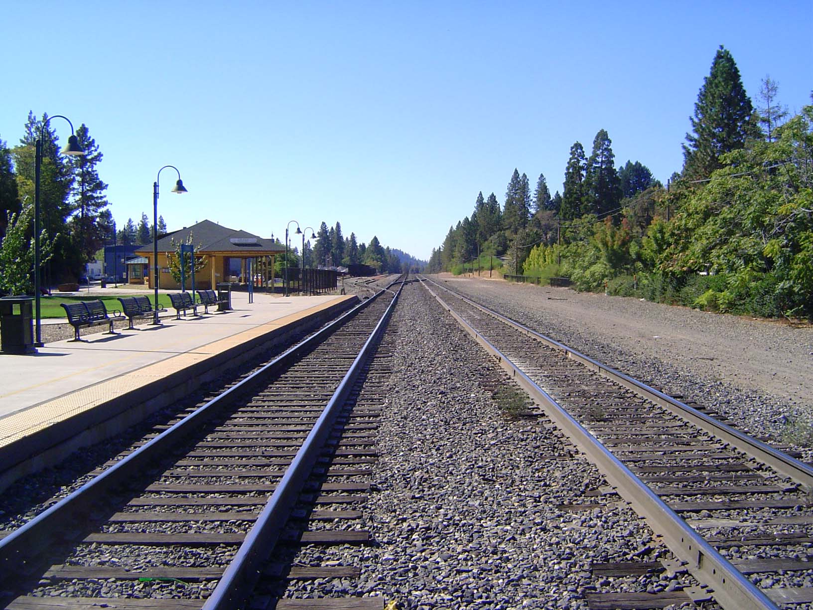
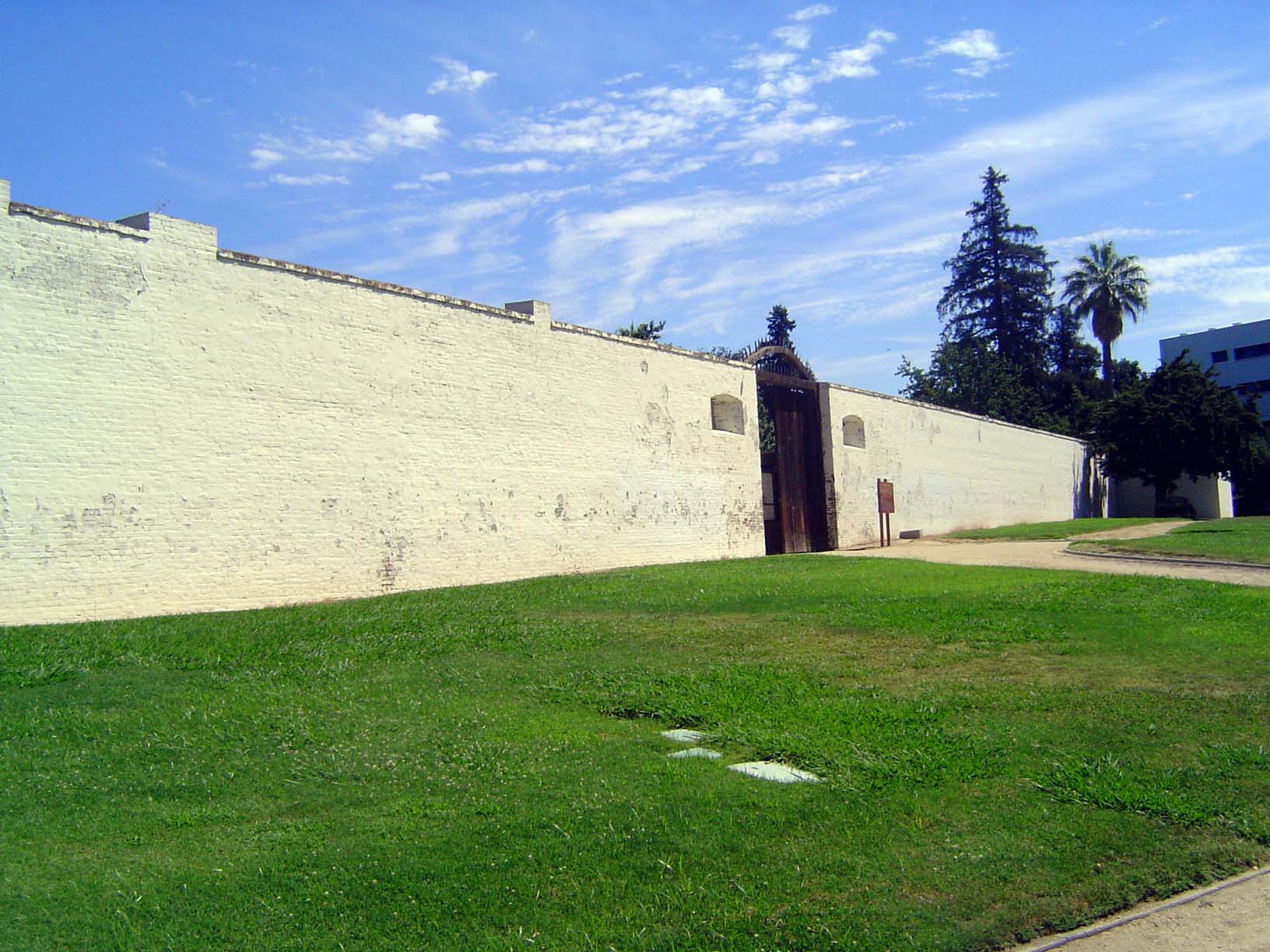
This folder samples the Central Paficic route to Truckee from here, Sacramento. We're looking at the wall of Sutter's Fort, center of Johann Sutter's New Helvetia. The fort had deteriorated badly by 1885, when restoration efforts began at the hands of the Native Sons of the Golden West. The wall was rebuilt by 1905.
Most of the fort's buildings were built against the outer wall, but this building—part of Sutter's personal quarters—projected toward the center.
Fireplace.
Kitchen.
Sutter's agrarian fortune would collapse with the Gold Rush, but there were newcomers to take his place. They included Huntington and Hopkins, who started out running a Sacramento hardware store. Forty years ago, the neighborhood was near collapse, but it's now been restored as part of an Old Sacramento State Historic Park. All along the line of the railroad across the Sierra, in fact, history has been discovered as a tourist-promotion strategy.
There is a vastly larger new Sacramento, of course, and it starts just beyond the elevated freeway.
A block from the hardware store, Sacramento also has the fine California State Railroad Museum, which includes a couple of engines from the pioneer period. This one is Central Pacific No. 1, built in Philadelphia in 1862, shipped around Cape Horn, and put in service while the railroad was still under construction. It remained in service until 1895. Named the Gov. Stanford, it was on display until 1963 at Stanford University.
The museum also has the only surviving SP cab-ahead engine. These immense engines, with a view far superior to that offered by the conventional rear-cab locomotive, were created so that engineers and firemen would no longer be nearly asphyxiated in the many mountain tunnels. The cab-ahead engine would have been difficult to arrange with a conventional coal-fired boiler, but the SP converted to oil just after 1900. The rest of the fleet—more than a hundred of these engines were built—was scrapped in the 1950s.
Although the SP kept the CP's locomotive shop at Sacramento, in 1908 it moved the freight yard 18 miles east to Roseville. The location is a few miles short of Rocklin, where the track hits granite, leaves the flat alluvium of the Sacramento Valley, and begins the long 7,000-foot climb to Donner Pass.
The Roseville yard—the U.P. now calls it the J.R. Davis Yard—is much too big to photograph from the ground. It covers about 700 acres spread over 6 track miles, and it contains a 55-track classification yard, along with 8-track receiving and departure yards. It's U.P.'s biggest freight yard on the West Coast, and it sorts ("blocks" in railroad lingo) 2,000 cars a day, so that when they arrive at smaller yards like Oakland or Fresno they don't have be sorted again for their final destinations. Notwithstanding a U.P investment of $140 million in the yard, the system was badly clogged when this picture was taken in October, 2005: the enlarged (not to say engorged) U.P. was no longer a smoothly functioning machine. Acute labor shortages, in particular, meant that whole trains were stuck on sidings.
Like Sacramento, Roseville is linking a downtown-rejuvenation project with history, not only with the historic U.S. 40 sign but with the street name Judah. Theodore Judah was the engineer—"crazy Judah," he was called—who surveyed the route that became the CP. He died of Yellow Fever in Panama just as the project was getting underway.
A few miles to the south, Folsom has jumped into history with both feet. Here, an old highway bridge, in service from 1893 to 1917, was refurbished and reopened to bicycle and pedestrian traffic in 2000. It crosses the American River downstream from Folsom Dam. The railroad will overlook the river farther east.
Speed and load warnings.
Sutter Street.
Sutter Street.
Sutter Street. Disneyland North?
Where the railroad hits granite at Rocklin, tunneling begins.
The date on this tunnel—the Clark Tunnel, through Boulder Ridge—indicates construction during the reign of E.H. Harriman, who briefly controlled the Southern Pacific as well as the Union Pacific and who invested huge sums in upgrading his properties, including double-tracking the Central Pacific. At many points, like this one, the second track diverges from the first in search of a better gradient.
These foothills, with a good climate and good access to rail transport, were soon planted to fruit trees.
Does the country look a little dry for fruit trees? Well, that's where irrigation ditches came in handy, like this one, which burbles over the top of the railroad tunnel a couple of pictures back; in fact, the tunnel's masonry entrance can be discerned just beyond the pole.
Towns sprouted, including Penryn, its name from Griffith Griffith, a Welsh miner who went into the granite-quarrying business. The town's Masonic Hall is shown here. Its date, of course, is less than a decade after the railroad's completion. The painted X on the pavement warns motorists of one of the CP tracks—the old one.
Penryn was also the site of a real-estate promoter's dream of attracting British colonists. As an amenity, Parker Whitney planted hundreds of palms: 869 survive and are the only living designated historic landmarks in California.
The foothill fruit was taken to track-side packing houses for shipment east in ice-cooled boxcars. These are the sheds in Newcastle, a few miles past Penryn. The fruit's gone, but the sheds have found a new use.
The mainline at Newcastle, with the old, now useless, siding that once served the packing sheds. The elevation here is about 1,000 feet. This was the end of the line in 1864, when the company was temporarily out of money.
We're at Auburn, 10 miles farther east and at an elevation of about 1,300 feet. This is Mother Lode country, and Auburn is the Placer County seat. The picture illustrates not only the former county courthouse, proud on its hill, but the ethnic diversity of California.
The town's banks have moved to newer commercial districts, and the old core has begun mining its own history.
One part of Auburn has been spared the rewrite.
An Auburn street stretches up to the old railway station. (If you're in the mood, why, you can buy some Thomas Kinkades at that shop on the right.)
The station.
But check this: we're looking at new rail. Look closely at the branding. See it? The rail was made in Japan. Sic volvere Parcas. There's only one track here, because the newer line is on the other side of town, along with the Amtrak station.
Another 10 miles uphill: Colfax, elevation 2,400 feet.
A new statue of Schuyler Colfax himself. Is he unfamiliar? He was the Speaker of the House of Representatives in 1865, when Lincoln asked him to go out to California and assure Western miners about their importance to the nation. Colfax spent two months travelling west by stagecoach. Arriving in Sacramento, he was taken by train to the end of the line, where a town was created and named for him. In later years, Colfax was Grant's vice-president. The best empirical evidence suggests that Colfax doesn't mind being nearly forgotten.
Here, too, in Colfax, the history bug is raging. Back in the 1960s, this strip was dead but not buried. It's alive again.
A couple of miles to the north, a 1924 concrete-arch bridge over the Bear River was, according to a plaque, "saved from the wrecker's ball in 1986." Restricted now to pedestrian use, the bridge is a good indicator of the local devotion to the past. The new and much higher bridge is partly visible at the right edge of the frame.
The railroad makes a big S-curve at Colfax, crosses Interstate 80, and heads to its first bit of scenery. The bridges are more of Harriman's work; they replaced the original timber trestle.
The scenic point is Cape Horn, where the railroad overlooks the American River Canyon. The cliff here is famous in railroad lore, because it was cut by Chinese laborers lowered in baskets from the cliff top. There's only one track here; the new one runs through a long tunnel through the ridge.
The same scene, showing Cape Horn in its setting. Who named it Cape Horn? Presumably someone who, in pre-railroad days, had come here on a long voyage around South America.
Dutch Flat, another 10 miles up the line. Founded in 1851, it had Placer County's largest voting population in 1860, which helps explain why Judah came here to begin building public interest in the transcontinental railroad.
There aren't many buildings left in Dutch Flat, but many of the survivors look set to last another couple of centuries.
The Dutch Flat Hotel, its ground floor built in 1851.
A few miles past Dutch Flat, the railroad hugs the north side of the American River Canyon, which here is about 2,000 feet deep.
Oops! A freight rolls through.
We're at Blue Canyon, elevation 4,700 feet. The old ice-cooled fruit cars used to be seriously dripping by the time they were dragged here by the cab-aheads. Here, instead, is Amtrak's California Zephyr. The name is mildly offensive to rail buffs: it properly belongs to the Western Pacific, which used to run streamlined trains of that name two canyons north, along the Feather River. The WP route, now also controlled by the U.P., has no passenger service, however, so the name has been transplanted here.
By Blue Canyon we've moved out of the flat-topped ridges of the mid-Sierra into more rugged, glaciated country. The winters, and the trucks running in winter on chains, are hard on the highway surface. The tracks are off to the right, but they're about to cross a divide, leave the American River basin, and continue east along the south side of the valley of the South Yuba River.
We're in the valley of the South (or South Fork) Yuba River and chasing the Zephyr.
Here's that same bridge, seen from its south side. The Interstate is now on the north side of the Yuba and at the toe of the rightly-named Red Mountain. Until the development of rotary snowplows about 1900, the trains here ran through 40 miles of wooden snow sheds, frequently set alight by stray locomotive sparks. To protect the sheds, the CP maintained a lookout in a cabin at the top of Red Mountain. Maybe they're rotted away now, but in the 1960s you could still see a huge accumulation of empty tin cans near the old lookout cabin.
The same bridge, one last time, with a view of the south wall of the Yuba's valley.
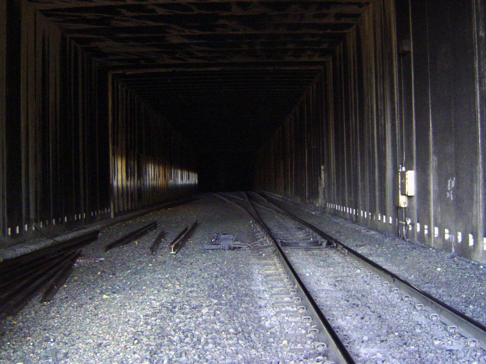
The wooden snowsheds were unceremoniously pulled down in the 1960s. The new sheds are of prefabricated concrete and are restricted to the occasional points where slides are most common. Yes, that's a bit of the Zephyr.
Bits of the old sheds are scattered about as a handy reminder that the sheds were not flimsy structures.
Shed frames were massive.
A close-up of the new sheds.
An interior.
And here's that same Zephyr, now running through Summit Valley.
The East Side, with Truckee beyond Donner Lake and with old U.S. 40 snaking down that way. The Interstate is routed north of here, while the railroad runs around the ridge on the right. The two tracks separate at the summit, with the old line running through a short tunnel and the newer one running through a 2-mile-long one, but they join again and wind down the hill seen here on the right. The tracks take advantage of side valleys—Lakeview Canyon and Coldstream Valley—and loop into them to ease the grade.
Truckee, elevation 5,800 feet, where the heavy construction ended and the railroad continued east through the modest Truckee River Canyon, past Reno, and out across Nevada.
Main Street early in the morning: Truckee, too, has discovered money in them thar tourists.
Bay Area East.
Safeway is a mile to the west, where modern services are clustered.
A B&B.
Old railway-worker housing.
Pre-gentrification.
The Star Hotel was built as his own house by George Shaffer, a pioneer lumberman who, before the railroad was open over Donner Pass, managed to skid a locomotive over the summit so work could continue farther east. Shaffer made the house a hotel in 1871, and it stayed open as such at least until 1986.
A couple of miles north of town, an innocent-looking meadow.
Alder Creek. Idyllic?
Depends who's looking. This is one of two camps of the Donner Party; it's much, much less visited than the one near Donner Lake. Twenty-five people were stranded here in the winter of 1846; 11 survived.
A few miles farther north, another broad valley, Kyburz Flat, significant because in pre-railroad days it was part of the stagecoach route over the Sierra via Henness Pass.
Ruins of More's Station on the route of the California Stage Company.