Home Up2. From Harare to Masvingo
For a podcast episode about these places, find The Places Where We Belong and listen to Chapter 2, Part 1.
We'll drive about 200 miles today, from Harare to Masvingo with a side trip at Chivhu to visit the church built by Arthur Cripps, a poet-missionary who spent his life in service.
Zimbabwe's a basket case, right? Well, there are basket cases and basket cases. If this is the way into (and out of) Harare on a weekday morning, it's safe to say that the economy has not completely collapsed.
This was early in 2018, with Robert Mugabe recently departed. From a repeat visitor's perspective, the most impressive thing, besides more traffic, was the complete absence of police checkpoints, alias bribe-uptake stations.
Maybe an hour down the road. If we were bus conductors on the express service we'd sing, "Chivhu, Masvingo, Beitbridge, Polokwane, Pretoria, Johannesburg, Harrismith, Pietermaritzburg, and Durban." That's a thousand miles.
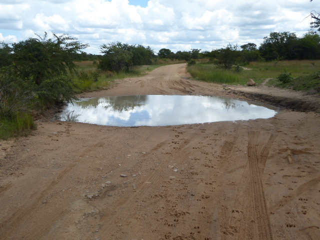
The road surface isn't as good as in South Africa, but it's not bad, and there's a lot to be said for roads where most of the time you can drift over the center line without incident. Too bad we're not 50 years earlier, when Rhodesia economized by building strip roads: two narrow strips of asphalt just right for automobiles. Oncoming vehicle? Bear to the side, so two of your wheels tires are on a track and two aren't.
A sign of poverty?
People buy firewood in posh American suburbs, but the wood there isn't hacked by axes, as it is here. Implication: the woodcutter can't afford a sharp saw, let alone a chainsaw.
Where's that rural economist when we need him? Here's the problem: who can pay $4 for 25 pounds of potatoes? Answer: not the people who live around here. The buyers are people rich enough to have cars.
Despite the good news of highways without traffic, the news in the countryside is bad, with cropland reverting to bush.
We won't see any tobacco, and there won't be much of anything else except relics of colonial infrastructure like this low-level pipe culvert bridge.
This, along with strip roads, is what once made driving in Africa fun. It's assumed that you're a big boy and don't need guard rails. Just don't try it at night after a good time at the pub.
Sissy stuff: this bridge is a Callender-Hamilton prefabricated truss. Its special appeal is that it requires no welding. The technology was patented in 1935 by the engineer who built Kurdistan's Hamilton Road, which runs east from Erbil to the Iranian border. This example is on the old road through Beatrice and is now bypassed by the highway.
Phone lines run along the road, too. Oops: ran.
We're 80 miles from Harare and in Enkeldoorn ("one thorn," referring to a now-vanished Vachellia robusta). The town is now called Chivhu ("anthill"), but the old name survives a bit.
The road is momentarily preempted by trays for oversized dumptrucks.
Yes, they have pilot cars.
Despite the name, this particular tray was made in Peoria, Illinois, probably came to Durban, and is working its way north. Destination? I'm guessing the coal fields around Tete, Mozambique. That's a 1,300-mile hike. Begs the question: why not offload at Maputo or Beira or Nacala?
Enough metaphysical speculation: here's Chivhu's pub, formerly the Enkeldoorn Hotel.
To get more floor space, the owner of this hardware store sacrificed the veranda.
The main commercial street runs perpendicular to the highway.
Poor but tidy.
Here's some recent investment: one of Zimbabwe's 40-odd SPAR supermarkets, run out of South Africa.
And here's a church from the days of Enkeldoorn. Guess the denomination: the facade on the right should tell you.
There you go: Dutch Reformed. The English version of the verse is "Let them make me a sanctuary, that I may dwell among them." Well, it didn't work out that way. The Afrikaners have all left town.
A High Aperture Anonymous Pillar box made by McDowall and Steven, London and Falkirk. It's said to be "anonymous" because there was never a royal insignia.
Detour: we're heading back north on Cripps Road, parallel to the highway and just east of town.
Dare we? This is a passenger car. Answer: yes, but stay to the right side and for heaven's sake don't slow down.
Here's what we want, one kilometer off to the left. Puddles from recent rain mean we mostly have to walk.
Whether it's a shrine is open to question. It's certainly the ruin of the church built by Arthur Shearly Cripps (1869-1952), an Oxford graduate and Anglican missionary who came to this place in 1902 and stayed with few interruptions until his death, by which time he was blind and dependent on the people he had spent his life serving.
Cripps made no attempt to build a Gothic or Romanesque church, as, for example, did Clement Scott, the equally untutored architect of the huge church in Blantyre, Malawi.
Without angles, the building instead echoes Great Zimbabwe, though in this case without shaping the stones or laying them in courses.
Altar.
Grave.
The original tombstone. Cripps has been the subject of at least three books: a sober biography (God's Irregular, by Douglas V. Steer, 1973), an imaginative reconstruction by a great-nephew (The Dust Diaries, by Owen Sheers, 2004), and an appraisal of Cripps's practical accomplishments helping the people around him (Maronda Mashanu, by Murray Steele, 2017).
We've continued south and arrived at the main corner in Masvingo, known as Fort Victoria (or colloquially as Victoria or Fort Vic) until 1982. The sign to the airport is misleading: flights to Harare and Bulawayo were listed in the May, 1999, issue of the Official Airline Guide but they were gone by 2001.
Beitbridge, across the Limpopo and 180 miles farther along the road we've been on, marks the South African border. The Great Zimbabwe University is a post-independence institution just outside of town.
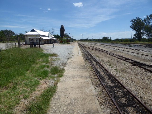
Fort Victoria got a railroad in 1915, but it was only a spur from Gwelo, which is on the mainline from Bulawayo to Harare. That isolation was pretty much curtains for the town's ambitions.
The station is substantial enough that you might think there were passenger trains, and it's true that The South and East African Year Book and Guide for 1929 says that "since the completion of the Railway to Victoria in 1915, this township and the ruins at Great Zimbabwe have been brought within easy reach of the traveller." By the 1950s, however, Rhodesian Railways instead ran buses to and from Fort Victoria. It apparently wasn't quite the end: you can find photos of the occasional passenger train here at least until the early 1960s.
See https://www.flickr.com/photos/windlass21/5711287794
No point in being patient today, unless you're willing to ride the very occasional freight.
At the edge of town, an impromptu market has sprung up along the track.
Mindful of the town's history, there's a German-built locomotive from the 1950s on the grounds of the grounds of the civic center.
Across the street, and at least into the 1950s, the bell in the city's watchtower was rung every night and morning—and had been since the town was established in 1891 as Southern Rhodesia's first town.
Government offices next door.
The departmental tenants have changed over the years.
A hotel on the main street sticks with the city's old name.
Across the street and down a block is the old Meikles department store, part of a Rhodesian chain. By 2018, the building on the left was still in business, barely, but the building on the right, a supermarket, was done.
Customary verandas survive; this bakery doesn't.
A once-stylish office building carries the name of a nearby reservoir built for sugarcane irrigation.
The city's streets are very, very wide. Here's the most important of them. Now it's the A4, but in colonial times it was Allan Wilson Street. The name may not ring bells for Americans, but Wilson led 1893's Shangani Patrol, which was wiped out in the First Matabele War and became a symbol of pioneer sacrifice. There's a very substantial Shangani Patrol memorial near the grave of Cecil Rhodes (see the Bulawayo folder).
A true boulevard, though with palms in need of dethatching.
Dethatching was taken too far in this case; the street is in an industrial neighborhood near the railroad station.
No median here, but still wide enough to more than meet the demands of traffic.
The town's one attempt at a highrise office building shares parking with a SPAR supermarket.
Things are generally pretty quiet.
Lots of colonial-era housing.
Some of it is well-hidden.
A late-colonial apartment block.
On the outskirts, there's new construction.
The civic center is still impressive as a sign of pride in the 1950s.
Several buildings are laid out as a group.
Posters in the civic center's theater.
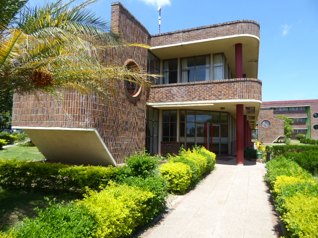
Masvingo Polytechnic is probably the most stylish building in town. The school celebrated its 25th commencement exercises in 2017 but was shut down the following year by students protesting the alleged misuse of Zimbabwe Manpower Development Funds (Zimdef) by the college administrators.
From another angle.
We're parked for gas; see the Great Zimbabwe mimicry?
Another example; the business is a mortuary. The real tower is a half-hour's drive away That's where we're headed.